Deadly tornado causes 'significant damage' in Arkansas
Central Arkansas suffered "significant damage" Friday, the state’s governor announced, after meteorologists said a tornado touched down in North Little Rock, pummeling buildings and leaving at least one person dead and two dozen injured.
Gov. Sarah Huckabee Sanders declared a state of emergency and activated the National Guard on Friday afternoon.
"Praying for all those who were and remain in the path of this storm," she said.
Huckabee Sanders said the town of Wynne, roughly 100 miles northeast of Little Rock, had also seen widespread damage.
The city's police chief, Richard Dennis, told NBC affiliate KAIT of Jonesboro, Ark., that the city of roughly 8,000 suffered "total destruction."
The twister that touched down in North Little Rock on Friday afternoon also damaged Jacksonville and Sherwood, meteorologist Travis Shelton said.
A spokeswoman for the emergency management agency in Pulaski County, which includes Little Rock, said one person had died from the severe weather. Additional details about the death were not immediately available.
Little Rock Mayor Frank Scott Jr. said 24 people had been hospitalized. Baptist Health Medical Center was treating 21 people at two facilities in the Little Rock area, a spokeswoman for the health system said. Five were in critical condition, she said.
The University of Arkansas for Medical Sciences Medical Center in Little Rock was operating at a mass casualty level and expecting at least 15 to 20 patients from the tornado, a spokesperson for the facility told the Associated Press.
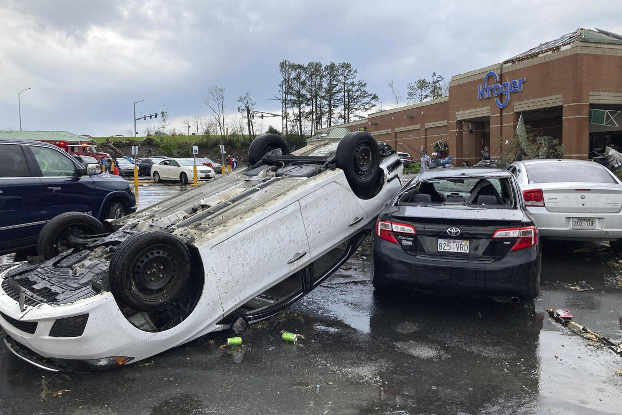
Images from Little Rock and the surrounding area showed battered vehicles, downed power lines, toppled trees and mangled homes. A photo broadcast by NBC affiliate KARK of Little Rock showed a Baskin Robbins that appeared to have its facade sheered off.
Kenneth Bruton was leaving a grocery store when he got in his pickup, looked back and saw the tornado coming over a hill.
“I got out of my truck and started running for shelter,” Bruton told KARK. The force of the wind knocked him down on his face, he said, but he was able to make it into a salon.
“And as I got in, huddled up against the cement barrier, every single glass window blew out, and people were blown back,” Bruton said. “And I held on. And it must have been a minute just huddled. I thought I was a goner for sure.”
The Arkansas State Emergency Operations Center issued a full activation in response to the severe weather Friday afternoon, according to a statement.
Almost 70,000 utility customers are without power in the state as of 6 p.m. E.T., according to poweroutage.us.
Tornado watches covered a swath from eastern Texas, into Arkansas and Kentucky and Tennessee, and north to eastern Iowa and southern Wisconsin at around 7:30 p.m. ET, according to the National Weather Service.
The agency warned that many tornadoes can be expected as well as “widespread hail up to apple size” and wind gusts up to 70 mph.
Kentucky Gov. Andy Beshear declared a state of emergency on Friday afternoon ahead of the severe weather expected in the western part of the state.
He noted that the western part of the state under threat is the same area devastated by tornadoes in December 2021.
“If you are in Western Kentucky, you need to be in a safe shelter by 5 p.m. Central Time,” Beshear said in a statement. “This is the worst forecast I’ve seen as Governor.”
In Tennessee, Tipton County and other areas were under a “tornado emergency" Friday evening. The weather service issued an urgent plea to the city of Covington to take shelter immediately.
Tipton County Sheriff Shannon Beasley said in a Facebook post there was damage to multiple homes and other structures, and he urged residents to stay out of the area.
Tornado warnings were issued in Iowa on Friday, and there were reports of tornadoes on the ground.
Video shared by NBC affiliate KWWL of Waterloo, Iowa, showed damage to buildings in Coralville, a city of around 22,000 adjacent to Iowa City.
Severe thunderstorms are also likely with flash flooding possible from the Midwest to the Lower Mississippi Valley on Friday, according to the National Weather Service.
Storms will move at speeds topping 55 mph and will go late into the night, making for very dangerous conditions, according to the National Weather Service.
Intense rainfall rates of up to 3 to 5 inches could bring flash floods to some areas. The areas with the greatest risk for flooding through Friday night are across the Ohio, Tennessee, and Lower Mississippi valleys.
This major storm system is set to spread weather hazards across the central and eastern U.S. over the next few days.
The severe weather comes a week after tornadoes hit Mississippi and Alabama, killing 26 people and causing widespread damage.
