'Parade of systems': Tallahassee forecast to see increasingly strong storms over coming days
A “conveyor belt” of storm systems, each more powerful than the last, is forecast to threaten the Tallahassee area over the next week, bringing the risk of flooding, tornadoes and hail.
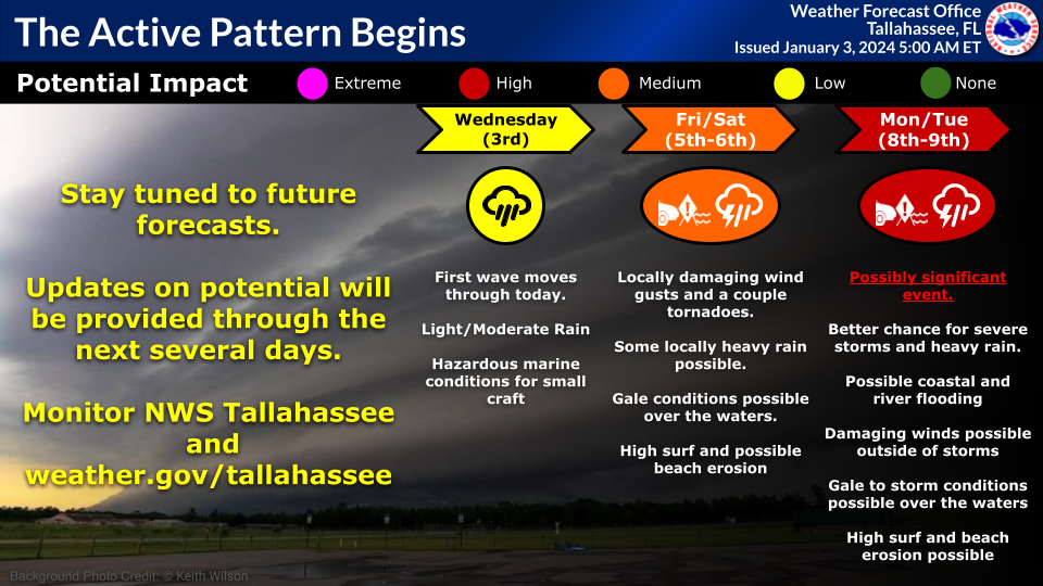
The back-to-back storms are expected to begin Wednesday afternoon as the weakest of the system brings light rain to the area. Forecasters say that is mere prelude to a stronger system arriving Friday night or Saturday and another more “dynamic” round of possibly severe storms Monday night into Tuesday.
"We're getting into a pretty active weather pattern to start the new year," said Israel Gonzalez, meteorologist for the National Weather Service in Tallahassee. "We're calling it like a parade of systems that are going to be coming every two to three days or so. And each one between now and next week is expected to be stronger than the previous one."
Gonzalez said computer models show an “unusual amount of agreement” in the potential potency of the third system, which could become a “significant event.”
“It looks like pretty much everything would be on the table with this system — all modes of severe weather possible,” he said. “Damaging winds, tornadoes, even hail. We could also be dealing with potential coastal flooding ... (and) dangerous marine conditions for sure.”
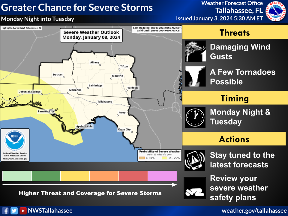
The Storm Prediction Center took the unusual step of calling for a 15-plus percent chance of severe weather for parts of North Florida next week in its six-day outlook. That corresponds to a slight risk (Level 2 of 5), though the Weather Service said that could be upgraded.
“When we see model guidance and signals this far out in that much agreement, that lends confidence into the event unfolding the way that it’s advertised,” he said.
The worst of the weather is currently forecast for an area just west of Tallahassee, though that could change, too, Gonzalez said.
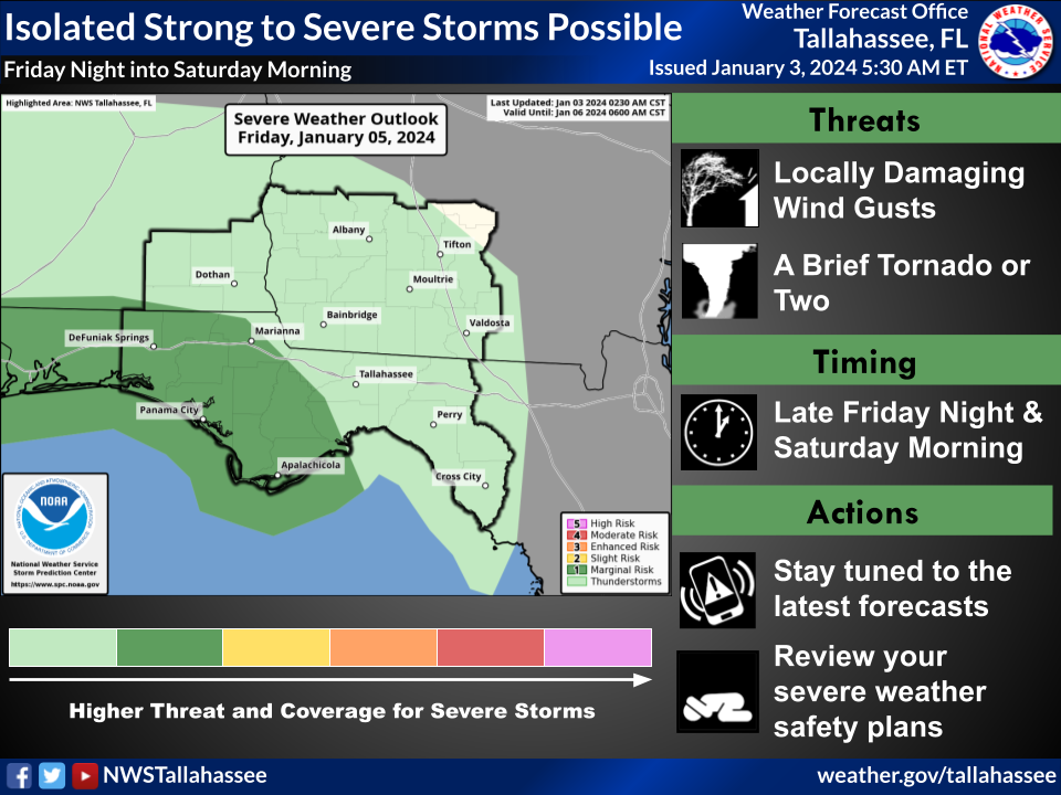
Isolated severe storms are possible Friday night and Saturday, mainly along the coast, with damaging wind gusts and a couple of tornadoes possible. The SPC assigned a marginal (Level 1 of 5) risk of severe weather for the western Big Bend, including Franklin and part of Wakulla counties. Beaches could see life-threatening high surf, with gales possible over the Gulf.
The Weather Service is calling for 1-3 inches of rain Friday and Saturday and 2-4 inches Monday and Tuesday, with periods of clearing and sun in between storms. Highs Friday through Tuesday will range from the low to upper 60s, with lows in the 40s and 50s.
The succession of storms is the product of El Niño, a natural weather pattern marked by warming surface temperatures in parts of the tropical Pacific Ocean. Gonzalez said that’s led to a stronger and more active subtropical jet stream. El Niño's intensity peaks during the winter.
“We are dealing with a moderate to strong El Niño so far this winter,” Gonzalez said. “So that’s providing a channel if you will — a steady conveyor belt — of all these systems that are coming in from the North Pacific ... and then the subtropical jet stream is just carrying them along the Gulf Coast, one after another.”
Cold night shelter opens
With overnight temperatures dipping into the 30s, Tallahassee's cold night shelter will open Wednesday and Thursday nights at the Kearney Center, 2650 Municipal Way. Intake is scheduled for 4-9 p.m.; transportation will be provided by StarMetro. For more information, call or text the street outreach coordinator at 850-759-1895 or email outreach@bigbendcoc.org. The shelter is provided through a partnership between local government, the Kearney Center and other agencies and nonprofits.
Contact Jeff Burlew at jburlew@tallahassee.com or 850-5999-2180.
This article originally appeared on Tallahassee Democrat: Tallahassee forecast to see 'conveyor belt' of storms, severe weather
