Oregon ice storm updates: News from Eugene, Springfield, Lane County, surrounding region
A relentless winter storm strengthened its icy grip on Eugene and the rest of Lane County this weekend, plunging the region into a deep freeze. Unusually low temperatures, combined with heavy snow and freezing rain, have transformed the area into an ice-covered landscape, prompting local governments to declare an emergency and state officials to warn residents to stay at home.
Icy roadways were left almost impassable, utilities warned of potential electrical outages, and public safety personnel were busy trying to keep up with emergency calls.
With the situation not expected to improve much on Sunday, Lane County and much of the rest of the Willamette Valley were expected to see more of the same. Here are the latest updates from Eugene and the surrounding region:
Another round of freezing rain forecast for Tuesday in Salem, Eugene, possibly Portland
As cities in the Willamette Valley attempt to dig themselves out from last Saturday’s mix of snow and ice amid frigid temperatures, more ice is on the way, officials said.
Another round of freezing rain could complicate travel and cause power outages from Salem to Eugene, and possibly in Portland as well, a winter storm watch said.
A total of 0.2 to 0.3 inches of ice is forecast for Tuesday in the central and southern Willamette Valley. The ice is expected begin in the morning and last into the evening.
It’s less than Saturday’s ice totals that reached a half-inch in some places, but enough to have widespread impact.
“We’ll definitely have some possibility of power outages, tree damage and slippery roads,” said Jacob Hall with the National Weather Service in Portland. “The good news is that we’re not forecasting strong winds.”
A winter storm watch from NWS indicated that the freezing rain could have a concentrated impact on the evening commute.
What about Portland?
While Salem to Eugene is forecast for freezing rain, what falls in Portland is a little less clear. Hall said it was likely to be a mix of snow and freezing rain.
In the Cascade Foothills, most of the precipitation will fall as freezing rain as well, with snow levels likely reaching around 2,000 feet, Hall said.
What about the foothills?
In the higher elevations of the Coast Range and Cascades, snow and ice is forecast. A winter weather watch says up to an inch of snow and 0.3 of an inch of freezing rain will be possible.
When will the freeze break?
The system of freezing air is finally expected to exit by late Tuesday night and into Wednesday. High temperatures return to the upper 40s or low 50s, and with rain forecast, it should melt much of the snow and ice fairly quickly.
Snow in the mountains?
Above about 2,000 to 2,500 feet, around 4 to 8 inches of snow is possible in the Coast Range and Cascades. That should turn to a mix of rain and snow by Wednesday and for the rest of the week.
Egan warming centers to open, requesting donations
The Egan Warming Centers will be open tonight and tomorrow night and they will remain open until 11 a.m. tomorrow morning instead of the usual 8 a.m. All sites are accessible to people with disabilities and to pets.
Egan Warming Center locations are:
Springfield Memorial Building
765 A St, Springfield
Doors open at 6:30 p.m.
Transportation Hub at First Christian Church
1166 Oak Street, Eugene
Shuttles will run from 6 p.m. to midnight
Trinity United Methodist Church
440 Maxwell Road, Eugene
Doors open at 6:30 p.m.
South Hills at the Episcopal Church of the Resurrection
3925 Hilyard St, Eugene
Doors open at 6:30 p.m.
Wheeler Pavilion at Lane Events Center
796 W 13th Ave, Eugene
Doors open at 10 p.m., a late opening
The Egan program is also seeking donations of gloves and blankets. It is looking for about 200 blankets and as many gloves as people can donate. People willing to travel are asked to bring donations to 888 Garfield Street in Eugene. People who don't want to travel but still want to help can send monetary donations to Egan's website: https://www.svdp.us/get-involved/give-back-donate-funds/
Power Outages and Hazards
Among the outages reported as of Sunday were:
8,022 Pacific Power customers are without power in Oregon as of 5:45 p.m., this includes 4,168 customers in Cottage Grove, 1,570 customers in Goshen, and additional outages
on Hungry Hill Roadnear Creswell and in Coburg. The utility projected most customers in the Cottage Grove area will get back power by Tuesday evening but some may have to wait until Wednesday evening. And most in the Junction City area will get back power by Monday evening but may have to wait until Tuesday evening.5,333 Eugene Water and Electric Board customers are without power as of 6:19 p.m. The largest outages are in near Cal Young Middle School, James Madison Middle School and east of Springfield. The utility said it is working to restore power but that customers should "prepare for multiple days without power."
Approximately 6,000 Springfield Utility Board customers are without power as of noon, mostly in east and southeast Springfield. SUB said crews are active but customers should be prepared to be without power for "several days."
The Emerald People's Utility District said it is working to restore power but there was "extensive damage" and that for many customers it will take "several days."
5,962 Lane Electric customers are without power as of 6:17 p.m. Lane Electric told customers to plan for potential outages until Friday because of damage to powerlines.
479 Blachly-Lane Electric customers are without power as of 6:24 p.m. The utility said it has begun repairing the Walton substation and that customers should prepare to "remain without power prepare to be out at least another night and potentially for multiple days."
8,779 Central Lincoln People's Utility District customers are without power as of 6:24 p.m., of customers with known locations, eight are in Lane County. The utility said it is working to restore power.
Closures and delays in Eugene, Springfield, Lane County
The severe weather has prompted closures and delays across Lane County, affecting various services and facilities:
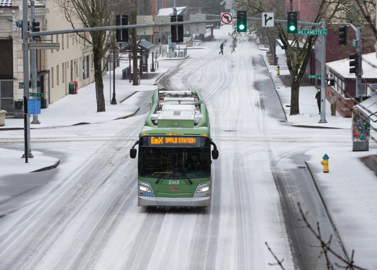
Lane Transit District: Bus services are suspended until further notice.
Lane Community College: Closed until further notice. The men's and women's basketball games against Chemeketa Community College have been postponed.
City of Eugene Parks: Immediate closure, caution advised near trees.
Eugene Airport: Numerous flight cancellations and delays.
University of Oregon Campus: Closing at 8 p.m. Saturday, reopening at 10 a.m. Monday. The Women's Basketball game will be played but will be closed to the public.
Willamalane Parks: Closed until further notice.
PeaceHealth: All specialty clinics, walk-in clinics, and urgent care will be closed tomorrow. Most elective surgeries will be rescheduled. Other hospital operations will continue.
Cascade Health: closed today and tomorrow except for the Pete Moore Hospice House.
Willamette Family: RideSource and Willamette Family drives are suspended until further notice. Other programs operating.
Willamette Valley Cancer Institute and Research Ctr.: Closed Monday.
Slocum Orthopedics: Closed today and tomorrow.
MLK Jr. Marches: Both the Martin Luther King Jr. Day march planned in Eugene and the one planned in Springfield are canceled.
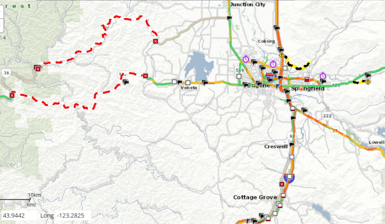
Road Closures
Deerhorn Road: Closed west of Booth Kelly Road due to falling trees and downed power lines.
McKenzie View Drive: Closed due to falling trees.
OR-126: Closed from Poodle Creek Road, Cheshire to Indian Creek Road, Swisshome due to hazardous trees or vegetation.
OR-36: Closed from Poodle Creek Road, Cheshire to Indian Creek Road, Swisshome due to hazardous trees or vegetation.
OR-99: Closed from E Saginaw Road to Lynx Hollow Road due to hazardous trees or vegetation.
Marcola Road: closed from Bowman Road to County Line Road due to fallen trees.
Territorial Highway: closed at milepost 42 due to fallen trees.
While not closed, state officials have warned of multiple crashes due to icy conditions on I-5 from miles 167-172 (Cottage Grove area)
What to do if your home or car is damaged due to the storm
The Oregon Division of Financial Regulation recommends calling your insurance company or agent before filing a claim if your home or car is damaged in the winter storm
Ask about your policy coverage, exclusions and deductibles to determine whether the benefits of filing a claim for the damage outweigh the costs to see if the amount of your damage could be less than or close to your deductible.
If you have insurance questions or concerns, contact the division's consumer advocates at 888-877-4894 or email dfr.insurancehelp@dcbs.oregon.gov
Oregon Health Authority warns of cold weather health risks
The Oregon Health Authority provided the following tips to avoid carbon monoxide poisoning, hyperthermia and frostbite.
Hypothermia and frostbite can settle in more quickly than usual when there is a windchill factor.
For carbon monoxide prevention:
Never use a gas stove or oven to heat the home.
Only use outdoor heaters, camp stoves, cooktops, grills, generators and similar items outdoors.
Generators should be used at least 25 feet away from your home.
Heat your home safely when utilizing space heaters, ensure the cord is not damaged and plug them directly into an outlet.
Keep anything that can burn at least three feet away from all heat sources including fireplaces, wood stoves, radiators, portable heaters and candles.
Oregon's Emergency Coordination Center activated
The Oregon Department of Emergency Management activated the State Emergency Coordination Center for state agencies and nonprofit partners to share life safety resources, including activating 211 to support warming shelters in several counties.
"If you or someone you know needs a place to stay warm, call 211 or visit 211info.org to find open warming centers in your area; 211 also offer and coordinate transport services to and from warming centers," the agency said.
Emergency Management encouraged people to stay home, stay informed, have an emergency plan and stock an emergency kit.
Oregonians can sign up for local emergency alerts at oralert.gov If you have moved, you should update your information.
The agency said a basic emergency supply kit in case the power goes out includes the following items:
Enough water for one gallon per person per day for several days, for drinking and sanitation.
Several days’ supply of non-perishable, easy-to-eat food such as peanut butter, protein and granola bars, jerky, nuts, fruit, pretzels, crackers, beans and rice.
A manual can opener.
A battery-powered or hand crank radio or a weather radio.
A flashlight with extra batteries.
A first-aid kit.
Sleeping bags or warm blankets.
NW Natural asks customers to conserve gas
NW Natural on Saturday evening asked customers to conserve gas during the storm "by lowering thermostats as much as you can comfortably and safely manage," minimizing hot water usage and turning off non-essential appliances, to help prevent strain on utility systems.
"We are seeing increased usage by utility customers across our region due to frigid temperatures, which are expected to continue into next week," NW Natural said in the notice to customers.
Modest efforts to conserve gas "can make a big impact in helping the entire energy system navigate this extreme weather event,” said Kim Rush, NW Natural's chief operations officer.
Rush said the company's gas system is operating safely at full capacity and field teams ready to respond to customer needs.
Weather system settles in over Oregon
The National Weather Service reports that a weather system has stalled over Oregon, intensifying the expected impact on the Willamette Valley and the surrounding mountains. The problems seemed to expand what original forecasts had suggested, with snow and ice spanning from Newport to Sweet Home, reaching down to Eugene and north to Tillamook.
Meteorologist Tom Schuldt warned Saturday of prolonged freezing rain and sleet through the weekend, urging residents to stay off the roads due to dangerous conditions. The storm's slower track means more precipitation, amplifying its impact on travel and everyday life.
Eugene weather warnings and forecast
The NWS placed Eugene under an Ice Storm Warning over the weekend, with freezing rain anticipated to cause significant and potentially damaging ice accumulation. Freezing rain was forecasted to fall throughout the night, although the temperature was expected to rise slightly on Sunday, to a high of 35 degrees.
Heading into Monday, Martin Luther King Jr. Day, temperatures are expected to remain cold, reaching a high of 35 degrees with mostly cloudy skies.
Eugene declares an emergency
The City of Eugene has declared an ice and snow emergency, implementing a parking ban on snow emergency routes. Residents are urged to remove vehicles immediately. City crews are also addressing tree hazards, and residents can report tree-related dangers by calling 541-682-4800.
As Eugene battles this winter onslaught, staying informed, following safety precautions, and cooperating with emergency measures are paramount. The community's resilience will be tested, but together, Eugene will weather the storm. Stay safe and heed official advisories.
What is freezing rain?
Freezing rain is a meteorological phenomenon that occurs when raindrops fall from the atmosphere in liquid form but freeze upon contact with surfaces that are at or below freezing temperatures. This results in a layer of ice forming on various objects, including roads, trees, power lines, and other structures. Here's a detailed description of freezing rain:
Formation Process:
Freezing rain begins as precipitation in the form of liquid water droplets high in the atmosphere.
As these droplets descend, they pass through a layer of sub-freezing air near the surface.
Upon contact with surfaces such as the ground, vegetation, or other structures, the liquid droplets freeze, forming a thin layer of ice.
Conditions Required:
The presence of a warm air mass aloft: Freezing rain typically occurs when a layer of warmer air exists above the freezing layer at the surface.
Shallow layer of freezing air near the ground: A layer of sub-freezing temperatures near the surface is essential for the raindrops to freeze upon contact.
Impact on Surfaces:
Roads and Sidewalks: Freezing rain can create hazardous conditions on roads and sidewalks, turning them into icy surfaces. This poses a significant risk for transportation as vehicles and pedestrians may slip or slide.
Trees and Power Lines: The weight of the accumulating ice on trees and power lines can lead to structural damage. Branches may break off, and power lines may sag or even snap under the added load.
Travel Disruptions:
Freezing rain is known for causing disruptions in transportation, leading to dangerous road conditions. Ice accumulation on roads reduces traction and increases the likelihood of accidents.
Air travel can also be affected as ice accumulation on aircraft surfaces poses safety concerns.
Power Outages:
The accumulation of ice on power lines and electrical infrastructure can lead to power outages. The added weight can cause lines to sag or break, disrupting the flow of electricity.
Duration and Intensity:
Freezing rain events can vary in duration and intensity. Some events may result in only a thin glaze of ice, while others can lead to more substantial ice accumulation, causing widespread damage.
8 things to do in a winter storm while driving
Driving through extreme weather is especially ill-advised and can, of course, be treacherous. According to the U.S. Department of Transportation Federal Highway Administration, there are an average of more than 1.25 million weather-related crashes on U.S. roads each year. But while it's best to avoid driving in bad weather, snowy and unpredictable conditions can catch out even the most cautious drivers. Therefore, it pays to be prepared. And these handy tips can help you stay safe if you get stuck on the road in your vehicle when extreme weather strikes.
First, it's important that you try to keep your car's gas tank as close to full as possible. Storms can arrive or worsen quickly, and running out of gas can put you in danger.
If you're stopped or stuck, try to make sure your car is somewhere safe and visible. It's important in case you need to be rescued. Also, stay in your car.
Be prepared by keeping snacks and water in your vehicle. When you're stuck, it might be for hours.
If you're stopped for a long period of time, try to run your engine for only about 10 minutes every hour. Sitting in an idling car wastes fuel and could expose you and your passengers to harmful fumes, according to the Environmental Defense Fund.
Another thing to keep on hand in your car is a portable battery to charge phones and other devices.
When your car is running, it's a good time to open a window for ventilation.
If temperatures get really low, try to bundle up with all the clothes and jackets you have on hand.
If you are stopped in heavy snow, make sure the area around your tailpipe is clear to avoid poisonous carbon monoxide exhaust fumes backing up into the vehicle.
Preparation, they say, is the key to success. But in bad weather, it may also be the key to survival.
More problems, solved
Winter: How to defrost windshields
Winter: What to do during a power outage
Pet safety: How to keep pets safe during winter
Gardening: How to prep your garden for winter
Hidden dangers of ice
Although it might not seem like a big deal, slipping on ice can result in serious injuries. You could try a few techniques to make your way over slick sidewalks by doing your best penguin impression.
To prevent falls on slick ice:
◾ Wear slip-resistant footwear.
◾ Take short, shuffling steps – similar to a penguin's walk – to maintain your balance.
◾ Keep your arms at your sides.
◾ Maintain the center of gravity over your leg that is in front.
This article originally appeared on Register-Guard: Updates: Eugene ice storm prompts closures, crashes, state of emergency
