Ophelia to drench the mid-Atlantic, Northeast through early week


As AccuWeather expert meteorologists accurately predicted, Ophelia made landfall just before dawn on Saturday morning near Emerald Isle, North Carolina. Ophelia's shield of rain and wind continues to extend primarily to the north of its center of circulation, drenching parts of the Northeast to start the week.
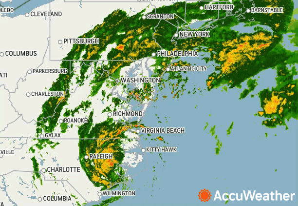
Radar snapshots of Ophelia on Saturday helped to illustrate the storm's far-reaching effects across the eastern United States. Although the center of circulation was located over eastern North Carolina during the morning, rain and gusty winds had already extended into places like Nantucket, Massachusetts, and wet weather continued to expand northward from there.
 |
A look at Tropical Storm Ophelia on radar after landfall Saturday morning. |
Through Monday, Ophelia will slow track back offshore off the mid-Atlantic states, prolonging the duration of wet weather and gusty winds. Although Ophelia will continue to lose wind intensity through early week, gusty winds and drenching rain can continue to impact many communities near the coast from the mid-Atlantic into southern New England.
 |
Many river, creek and bay waters have already experienced rises into moderate and major flood stage from Ophelia during Saturday and Sunday morning's high tide cycle. However, due to the slow-forward movement of the storm, conditions and water levels will need to be monitored with each upcoming high tide cycle through early this week.
 |
Despite astronomical tides being at a relative minimum, the tidewater regions of North Carolina, Virginia, Delaware and Maryland have dealt with water levels well above typical high tides. In some cases, water rises over 3 feet above normal high tide levels were observed, which inundated low-lying sections of coastal communities across the region.
The effects will continue to be felt farther north, as powerful surf will batter the coastlines and intercoastal waters of New Jersey and even Long Island. These hazards will extend into this week up and down the coast as Ophelia continues to churn up the water.
A cold and steady rain dampened weekend plans across a wide swath of the mid-Atlantic and Northeast and there is still more to come for some into early this week. With Ophelia continuing to track slowly near the coast, many of the same communities that have already seen the rain will continue to do so through Monday.
 |
Rainfall totals of an inch or more of rain has been observed from coastal South Carolina to coastal Massachusetts from Ophelia. Effects have not been felt just along the coast, as an inch or more of rain has extended well inland into the central Appalachians.
A swath of 2-4 inches will focus a little closer to the coast, but the area under this risk still encompasses many major metropolitan areas along the Interstate 95 corridor. Washington DC, Baltimore, Philadelphia, New York City and even up into southern New England can experience rainfall amounts that can lead to flooding on roadways, swell creeks and rivers beyond their banks, causing headaches at many major airport hubs.
The core of the heaviest rainfall totals from Ophelia occured in areas close to the center of the storms' path, with rain totaling 4-8 inches with an AccuWeather Local StormMax™ of 12 inches from the low-lying tidewater regions of North Carolina, Virginia, Delaware, Maryland and up into southern New Jersey.
Despite Ophelia moving inland and beginning to lose wind intensity, strong gusty winds capable of producing localized power outages and downed trees are still possible in some Northeastern coastal areas through Monday. Upon landfall early Saturday morning, Ophelia produced a 73-mph wind gust at Cape Lookout, North Carolina, and had knocked out power to more than 80,000 customers.
 |
Factoring in the drenching rain that has and will continue to fall, wind gusts in the 40- to 60-mph range can uproot trees easily with the ground already saturated. In many cases, downed trees or tree limbs can be one of the most common causes of power outages as they frequently land on power lines.
Ophelia will continue to lose wind intensity through early this week, but that does not mean the impacts from the storm will quickly diminish. A steady, soaking rain can continue through the day on Monday across the mid-Atlantic and portions of the Northeast. Ophelia is expected to further lose wind and rain intensity into the day on Monday, but a damp, dreary and cold start to the week can still be expected in places like New York City.
Direct impacts in the form of rain and wind should come to an end by the end of the day on Monday across the Northeast and mid-Atlantic states. Following the storm, there will be cleanup efforts ongoing across some of the hardest-hit areas in the days and perhaps weeks to follow.
 |
Conditions should dry out by Tuesday and Wednesday of the upcoming week in the hardest-hit communities along the Atlantic coast and adjacent tidewaters. Mother Nature may not cooperate completely, however, as a gusty northeast wind will linger and lead to continued rough surf and high water issues at times of high tide through much of this week. In addition to that, temperatures will likely fall below the historical average in many places with a cool wind blowing off the Atlantic.
 |
Want next-level safety, ad-free? Unlock advanced, hyperlocal severe weather alerts when you subscribe to Premium+ on the AccuWeather app. AccuWeather Alerts™ are prompted by our expert meteorologists who monitor and analyze dangerous weather risks 24/7 to keep you and your family safer.
