Oak Fire update: New infrared images show where Yosemite-area wildfire burns hottest
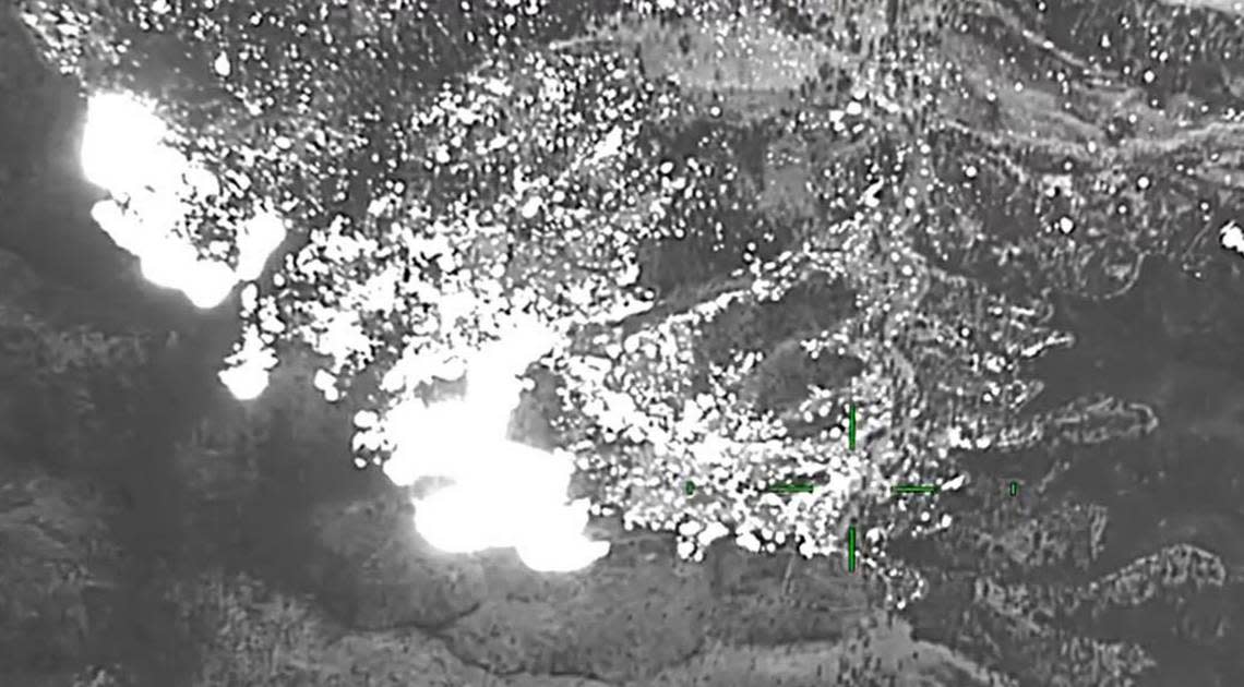
New infrared video taken by aircraft flying over the Oak Fire near Mariposa on Monday afternoon shows significant hot spots where the wildfire is burning with the most ferocity.
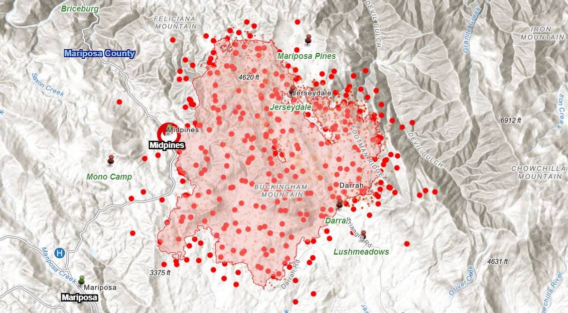
A reconnaissance flight by the state Office of Emergency Services for its Fire Integrated Real-time Intelligence System, or FIRIS, shortly after 12:30 p.m. indicates significant heat activity at the northern and northeastern edges of the fire’s perimeter.
In a trio of videos posted to Twitter, a FIRIS pilot reported that the fire is now mapped at more than 17,000 acres, a slight increase from Monday morning’s estimate of 16,791 acres.
In one area, video shows the Oak Fire burning its way down a slope east into Devil’s Gulch, east of Jerseydale. Another video shows white-hot areas at the northern edge of the fire, where air drops of water and fire-retardant chemicals from helicopters and airplanes are being used to help check the fire’s spread.
OES Intel 12, July 25th on the #OakFire, MMU. Fire is mapped at 17,038 acres at 12:37 hours. Video #1 pic.twitter.com/zNCXBiHV9A
— FIRIS (@FIRIS) July 25, 2022
The videos underscore what firefighters have said about the speed at which the Oak Fire has grown since it started Friday. By Saturday morning, it had blistered more than 6,500 acres, quickly becoming the largest wildfire so far this year in California.
The fire has continued to expand, reaching more than 17,000 acres by early Monday afternoon. That makes it three times the size of the next largest fire, a May incident in Riverside County. “The fire fight continues in hot, dry conditions and steep, rugged terrain,” Cal Fire reported Monday.
Justin McComb, Cal Fire team 5 operations section chief, said the blaze “quickly outflanked” firefighters on the first day, saying they were unable to attack it with the resources on hand. “In my career I haven’t seen fire behavior like that,” McComb said.
McComb said on Sunday firefighters did have some success getting a line around the southern edge of the fire, using “dozers, everything we could” to stop the wildfire from spreading south. “That was a win for me,” he said.
Mike van Loben Sels, chief of Cal Fire’s Madera-Mariposa-Merced unit, said Sunday that the growth of the fire was “pretty amazing,” particularly given how quickly resources were sent there, and “how quickly the state supported the incident with all the aircraft across the board, from the very large air tankers that you guys see out there to the helicopters. We really threw everything at this thing from the beginning.”
Less intense fire behavior overnight Sunday allowed crews to start securing containment lines around part of the perimeter. By Monday, Cal Fire estimated containment of at 10%, but reported that full containment might not be achieved until July 30.
With afternoon high temperatures in the high 80s to low 90s, and breezes blowing at 13 to 15 mph, “we still have ripe conditions for the fire to take off and create more havoc,” Joe Amador, a fire information officer on the Oak Fire, told The Fresno Bee on Monday afternoon.
Nighttime conditions have also been dry, with low humidity creating a situation in which the fire continues to burn. Amador said fire crews might see relief overnight Monday as some monsoon moisture moves in, helping to increase the humidity and slowing the fire’s nighttime activity.
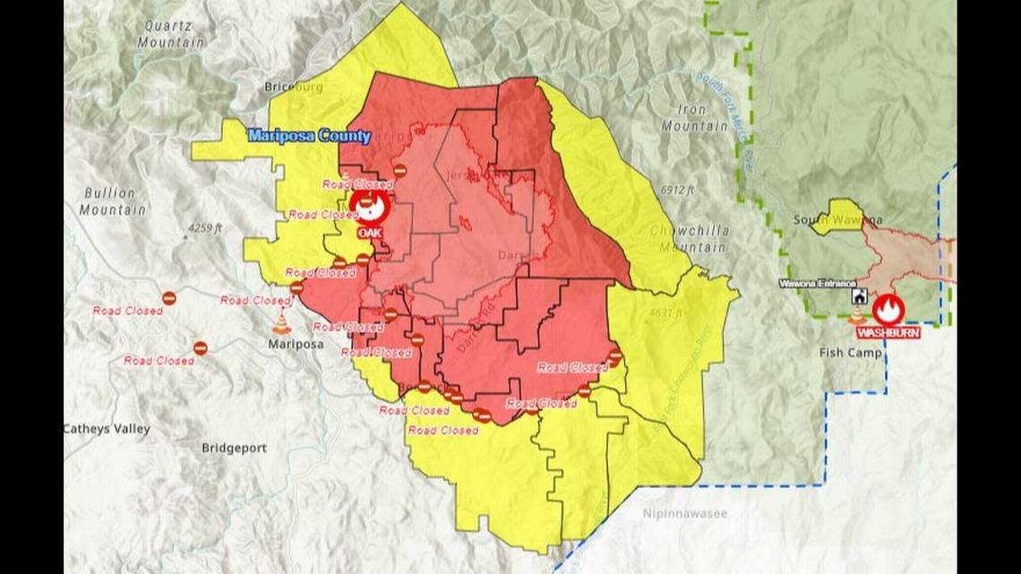
The Oak Fire quickly eclipsed the Washburn Fire, which is still burning about 10 miles to the east in Yosemite National Park and the adjacent Sierra National Forest. The Washburn Fire, which was ignited July 7 in Yosemite National Park’s Mariposa Grove, is at 4,875 acres and is about 87% contained, according to the National Interagency Fire Center and the National Park Service.
Another wildfire in the mountain area, the Agua Fire just west of Mariposa, began July 18 and is 100% contained by firefighters, Cal Fire reported.
Damage, resources
Seven homes have been destroyed by the Oak Fire, Cal Fire reported on Monday. That’s a revision downward from 10 structures, after damage assessment crews were able to do a more thorough survey of some of the burned areas.
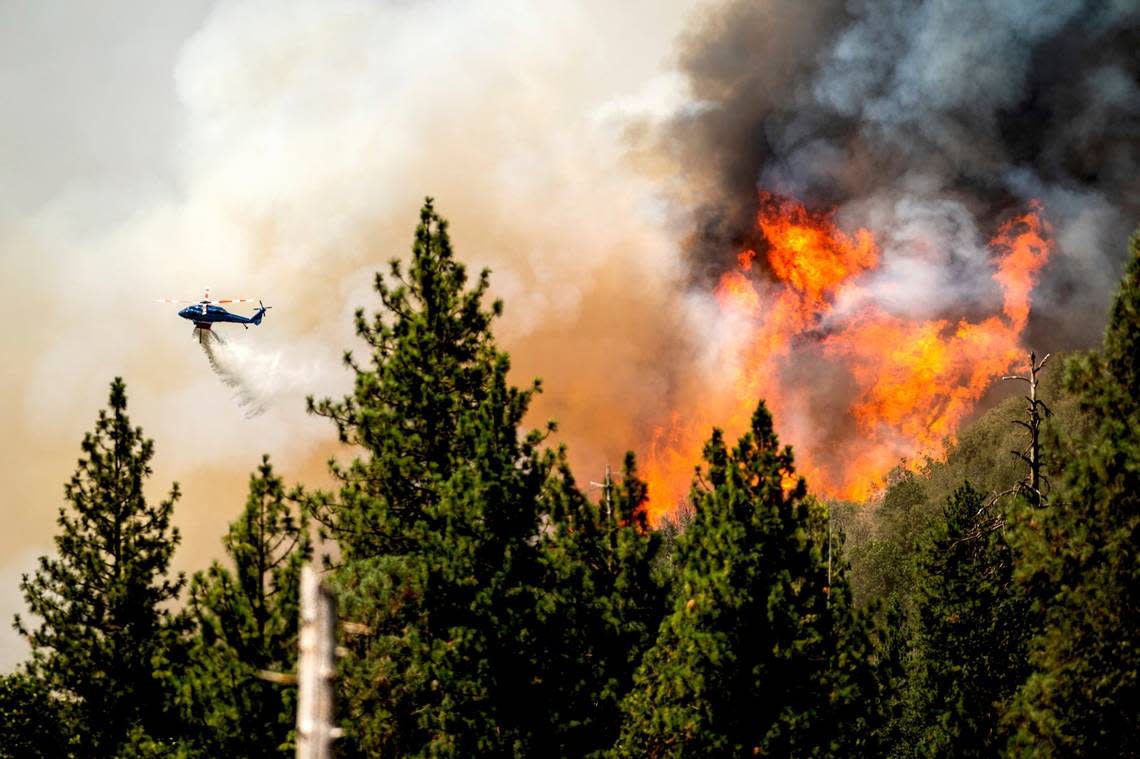
More than 2,500 firefighters are assigned to the fire, and resources include 17 helicopters, 281 fire engines, 66 bulldozers, 46 water tender trucks and hand crews on the ground working to carve containment lines around the blaze. Air tanker planes have also been called in to drop fire-retardant chemicals ahead of the flre lines to keep the flames from spreading.
Amador said no injuries have been reported among either firefighters or residents.
Swaths of mountain territory on all sides of the fire remain under mandatory evacuation orders, and evacuation warnings extend even further – as far north as Briceburg, east to Chowchilla Mountain, west toward Bullion Mountain and south to the Madera County line.
OES Intel 12, July 25th with video # 2 of the #OakFire, MMU. Fire mapped at 17,038 acres at 12:40. pic.twitter.com/nx1FxkIbbu
— FIRIS (@FIRIS) July 25, 2022
OES Intel 12, July 25th with video # 3 of the #OakFire, MMU. Fire is mapped at 17,038 acres. pic.twitter.com/XAS4kwclnV
— FIRIS (@FIRIS) July 25, 2022