Northeast's hottest weather of summer may come in early September

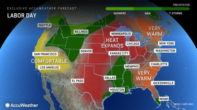
As cool weather fans rejoiced with their flannel shirts and pumpkin spice lattes leading up to Labor Day weekend, the atmosphere is cooking up some late-summer heat for the first full week of September, and some locations could soon rival their highest temperatures of the year, AccuWeather meteorologists say.
Thanks to a push of Canadian air, temperatures trended several to 10 degrees Fahrenheit below the historical average in much of the Northeast during the latter part of the week. Temperatures dipped into the upper 30s in the Adirondack Mountains of northern New York state and into the 40s to lower 50s over the rest of the northern and central Appalachians during the overnight hours.
Following daytime temperatures that will trend several degrees higher than prior days on Saturday afternoon, long sleeves and a jacket may continue to come in handy Saturday evening as temperatures drop.
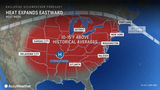
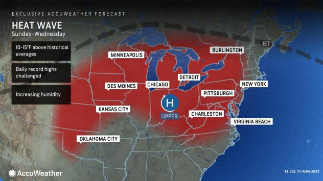
People enjoying the cool end to the week will soon be disappointed. Despite Sept. 1 marking the start of meteorological fall, it may be a little too early to put away the shorts and close up the pool for the season. Heat that began to build over the Plains at late week will expand eastward into the first week of September.
 |
In the Northeast, temperatures will trend upward substantially and energy demands will surge, according to AccuWeather Senior Meteorologist Dave Dombek.
"Late-summer warmth with highs in the 80s will transition to highs in the 90s in many areas," Dombek said, adding, "It is possible that New York City and other locations that have not yet had a heat wave, finally check that off the list next week."
In much of the Northeast, a heat wave is defined as three days in a row with high temperatures of 90 or greater.
 |
In New York's Central Park, where official highs for Manhattan are maintained, the temperature will flirt with the 90-degree mark from Monday to Wednesday. Central Park did not hit 90 at all in August. The last time the temperature in Central Park failed to reach 90 degrees in August was in 1986.
The most recent time temperatures reached 90 in the Big Apple was on July 27 and 28 with highs of 92. Another two-day stint of 90-degree temperatures occurred on July 5 and 6. The historical average high for New York City in early September is near the 80-degree mark.
It is possible that some locations match or top their highest temperatures of the summer during the early to middle part of next week. In New York City, that mark is 93 set on July 5.
Similar to New York City, the Pittsburgh metro area has not had an official heat wave yet this year. The highest temperature in August was 89 in the Steel City. Temperatures have only reached or exceeded 90 on two occasions this summer, once on June 3 and again on July 28. Temperatures will peak within a couple of degrees of 90 in Pittsburgh each afternoon from Sunday through Wednesday.
 |
Meanwhile, high temperatures of 90 degrees in Washington, D.C., and Baltimore are typically more common than in Pittsburgh or New York City during the summertime. Both locations have strung a number of 90-degree days together on multiple occasions. Both cities have seen temperatures max out at 97 degrees this summer.
The upcoming heat wave will push temperatures well into the 90s from Sunday to Tuesday and perhaps Wednesday of next week from Washington, D.C., to Philadelphia. Temperatures could flirt with the 100-degree mark in Washington, D.C., and Baltimore on a couple of those days, which would be season highs. The last time Washington, D.C. (Reagan National Airport) hit 100 in September was in 1980. Washington Dulles Airport has never hit 100 this month.
The season-high mark of 95 in Philadelphia could be matched or surpassed as well.
Farther to the northeast, cool air will hold on much longer in New England into next week. However, there is the chance that a spike of heat might occur where temperatures may surge well into the 80s to the low 90s during the early to middle part of next week. That could be dependent on the strength and track of Idalia, which will meander over the western Atlantic through much of next week.
Should Idalia strengthen and inch closer to eastern New England, it could help create a period of hotter air in New England next week. For now, AccuWeather meteorologists are projecting that temperatures will trend upward into the 80s early next week in Boston, before tailing off mid- to late week. It is from the early to the middle part of next week, when temperatures may surge higher.
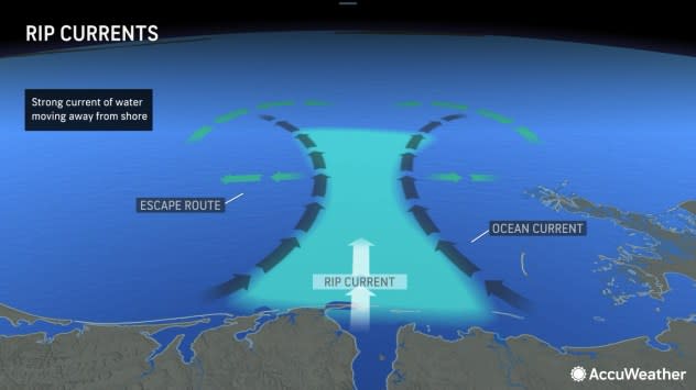
People heading to the beaches this weekend and those who have extended time off next week should be wary of the risk of frequent and strong rip currents.
Stiff winds created by the flow of air around high pressure and Idalia will produce large swells over the Atlantic into next week. As these swells migrate toward the coast, they tend to generate occasionally big waves and potentially increase the number of rip currents.
Experts urge swimmers, when possible, to only venture into the surf where lifeguards are on duty and/or to swim with groups of people and never swim when hazardous conditions have been posted on the beach.
 |
For hot weather fans, 2023 has brought "a bummer of a summer," AccuWeather Chief On-Air Meteorologist Bernie Rayno said.
Rayno was referring to the waves of cool air, episodes of smoke from Canadian wildfires and sieges of wet weather and flooding.
June was the coolest month overall with temperatures of 2-3 degrees below the historical average in much of the region. Frequent intrusions of cool air from Canada played a role, as did smoke, which helped to dim and block the sun's intensity while creating poor to dangerous air quality.
 |
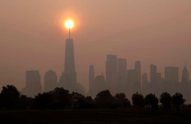
Smoke shrouds the skyline of lower Manhattan and One World Trade Center as the sun rises in New York City on June 30, 2023, as seen from Jersey City, New Jersey. (Photo by Gary Hershorn/Getty Images) |
However, for the summer season as a whole, temperatures in many areas during the three-month period from June 1 to Aug. 31, cumulative temperatures are finishing within 1 degree of the historical average and rainfall has ended up near the historical average.
A notable exception is in New England where summer rainfall was nearly two times that of the historical average, thanks in large part to excessive rain in July.
Want next-level safety, ad-free? Unlock advanced, hyperlocal severe weather alerts when you subscribe to Premium+ on the AccuWeather app. AccuWeather Alerts™ are prompted by our expert meteorologists who monitor and analyze dangerous weather risks 24/7 to keep you and your family safer.
