Spring 2024 weather forecast: NOAA says parts of all 50 states will be warm
A warm, damp spring is on tap for much of the U.S., federal forecasters predicted Thursday.
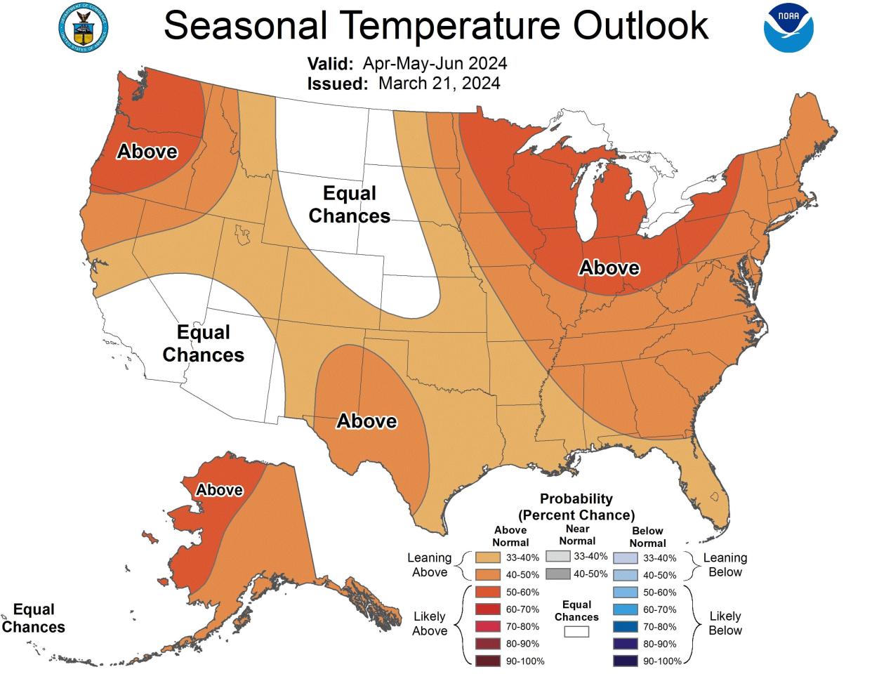
The warmth is expected to be widespread, with portions of all 50 states predicted to see above-average temperatures throughout the months of April, May and June. This will continue a pattern that included the record-warmest winter in U.S. weather history.
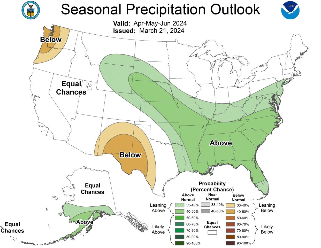
Rainfall should be above-average in the Southeast, which is also the region where flooding is most likely, the national spring forecast from NOAA's Climate Prediction Center said.
As for one of springtime's more notorious weather hazards – tornadoes – the forecast does not include where severe thunderstorms are most likely to strike over the next three months.
Where is a warm spring most likely?
While the warmth is expected from coast-to-coast this spring, the greatest chances for above-average temperatures are in the Great Lakes region, the Pacific Northwest and northwest Alaska, forecasters said.
The warmth also extends to Hawaii, where above-normal temperatures are forecast this spring for Kauai, Oahu and Maui, the Climate Prediction Center said.
No areas of below-normal temperatures are forecast for spring 2024.
Where will it be rainy this spring?
Precipitation should be above-average in portions of the central Plains, the southeastern U.S. and in southern Alaska. However, parts of the Pacific Northwest and Southwest are most likely to see precipitation below the seasonal average, NOAA said.
More: La Niña is coming: It could worsen hurricane season and affect US weather, forecasters say
Spring flood risk
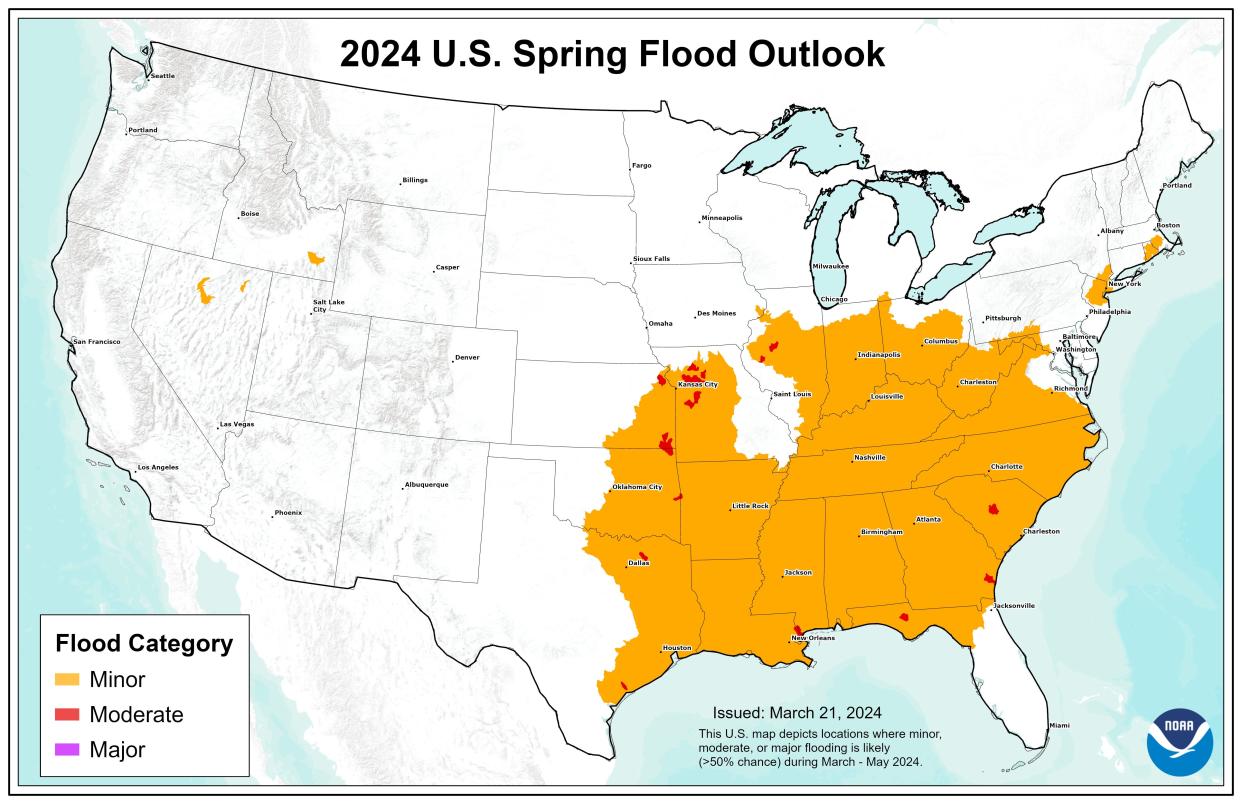
Federal forecasters said the overall threat of significant flooding this spring is low because of above-normal temperatures and historically-low snowpack.
“This is the first spring outlook since 2021 with no population expected to be impacted by major flooding," said Ed Clark, the director of NOAA’s National Water Center.
While no areas are expected to endure major or record flooding, the entire southeastern quadrant of the country could see minor flooding this spring, according to the flood outlook map from NOAA.
What about drought?
Drought conditions are likely to continue improving in the southeastern U.S.; however, the drought is likely to persist or even expand in portions of the Rocky Mountains and the Great Plains, NOAA said. As of Thursday's U.S. Drought Monitor, drought encompassed some 21% of the nation, and only 0.14% was in the worst level of drought.
Clark did express concern about the water levels along the Mississippi River, which was an issue last year: “Of growing concern will be the potentially low flows on the Mississippi River this summer into fall due to well-below snowpack and precipitation in most of the northern Plains and Midwest. This could have potential impacts on those navigation and commercial interests that depend on water from the Mississippi River.”
El Niño still a factor
Experts say the El Niño climate pattern is expected to continue impacting weather in the U.S. into the spring. This means ongoing warmth across much of the nation and wetter-than-average conditions across the southern tier.
“Our scientists at the Climate Prediction Center observed one of the strongest El Niño events on record during the winter of 2023-2024,” said Jon Gottschalck, a forecaster from NOAA’s Climate Prediction Center. “But a quick transition to La Niña — the cool phase of ENSO — is possible as early as the first part of summer.”
La Niña tends to boost the number of hurricanes that form in the Atlantic Ocean, forecasters warn. Atlantic hurricane season begins on June 1.
This article originally appeared on USA TODAY: Spring 2024 weather forecast: Where NOAA says it will be warm, rainy
