Spotty storms, dramatic cooldown to follow late-week surge of warmth in Northeast


Temperatures are set to spike late this week in the Northeast ahead of a wave of cool air that will arrive from an unusual direction. But while there are likely to be some thunderstorms during the temperature transition, they may do little to reverse the building dryness and drought in much of the region, AccuWeather meteorologists say.
A large buckle in the jet stream has been responsible for bringing cooler-than-historical average temperatures in the southeastern United States and warmer-than-average temperatures in much of southeastern Canada in recent days. The warmth in Canada will push southward and intensify over the Northeast into Friday.
A pattern more typical of the middle of summer - minus the high humidity - will set up across the Northeast by the end of the week with many interior locations approaching the 90-degree mark, AccuWeather Senior Meteorologist Brett Anderson said.
 |
Intense June sunshine will be able to squeeze every degree out of the atmosphere, and it won't have competition from high humidity levels or wet soil.
"Many areas in this region have been abnormally dry during May, which has depleted the moisture in the top layers of the soil," Anderson explained. "With little moisture in the ground, the sun's energy can go more directly to heating the air instead of evaporating water, which leads to higher temperatures."
Temperatures are forecast to spike across the northern tier of the Northeast prior to the mid-Atlantic region.
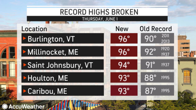
Burlington, Vermont, located on the shores of Lake Champlain, will rival record highs again on Friday. This comes one day after the city shattered the daily record of 90 - last reached in 2013 - with a high of 96. This was the earliest on record with a temperatures of 96 degrees in Burlington, surpassing to record of June 7, 2021. Temperatures also reached the 90s in northern Maine and part of northern New York on Thursday.
 |
The core of the heat will build farther to the south into Friday over much of the balance of New England and the mid-Atlantic states.
Highs will be within a few degrees of 90 in metro areas such as New York City, Philadelphia, Pittsburgh and Washington, D.C. Near-90-degree heat will be no stranger to the suburbs and rural areas in the mid-Atlantic and central Appalachians as well to end this week.
Most records at these locations are in the mid- to upper 90s and will remain intact late this week. However, the intense June sun and light winds in this setup will push AccuWeather RealFeel Sun® temperatures to the mid- to upper 90s in the urban areas during the afternoon hours.
Hot weather fans may want to soak up the heat into Friday as the surge of warmth will not continue into the weekend.
"A cold front is expected to charge southwestward through New England and into the Middle Atlantic region later Friday and into Saturday," Anderson said.
 |
When a push of cool air comes in from the northeast rather than the northwest, it is called a backdoor front. In the wake of the backdoor front, high temperatures in the 80s to near 90 will be swapped with highs in the 70s and even the 60s in some locations.
"As the front moves westward through the Boston area Friday night, temperatures may drop as much as 15 degrees in a few hours," Anderson said. "As the winds shift into the northeast, much cooler air will sweep in from the Atlantic," Anderson said.
Afternoon temperatures from New York to Baltimore on Saturday will likely be anywhere from 10-20 degrees lower than what they will be on Friday.
 |
A stiff, cool breeze will be present at most beaches in the region this weekend.
Although rain is needed, the downpours produced by the backdoor front may be sparse and brief.
Some areas may totally avoid rain altogether despite the front. However, a few locations may pick up a quick 0.10 to 0.30 of an inch if they endure the bulk of a heavy shower or thunderstorm.
"A few of the thunderstorms may produce locally strong wind gusts that can kick up dust and pollen," Anderson said.
 |
The storms will affect parts of New England and eastern upstate New York during Friday afternoon and night as the front advances from northeast to southwest.
"The front will reach eastern Pennsylvania and New Jersey on Saturday and spotty, gusty thunderstorms may refire just west of the leading edge of the cool air during the afternoon in central Pennsylvania, Delaware, Maryland, northern Virginia and western New York," Anderson said.
People spending time outdoors this weekend in these areas should be prepared for rapidly changing weather conditions from storms that move in from a different direction than usual.
A few locations may get enough rain to allow lawns to green up briefly.
While a southward dip in the jet stream could generate spotty afternoon showers into next week in the Northeast, the weather in many areas may remain bone dry.
This time of the year, especially when the air is dry, intense sunshine can draw 0.25 to 0.33 of an inch of water from the ground over the course of a day. A few missed rain opportunities can cause the situation to escalate and result in a flash drought.
Short-term dryness and moderate drought will cause lawns to go dormant, just as in the winter months.
 |
"Lawns are starting to show their thirst for water with some browning, which is more typical of late July and August," Anderson said.
Rain is essential this time of the year to allow planted crops to grow and lawn care industries and their dependent workers to generate income. Home gardeners may want to water their lawns or plants during the evening when evaporation rates are low and moisture has a chance to soak into the soil.
"May 2023 ended up being the driest on record for much of the Susquehanna Valley, including Harrisburg and Williamsport, Pennsylvania," AccuWeather Senior On-Air Meteorologist Justin Povick said. Typically 3.75 to 4 inches of rain falls in the region during May.
Only 0.20 of an inch of rain fell at Harrisburg, which shattered the old monthly record of 0.29 of an inch from 1902, Povick noted. That low rainfall amount could also allow May 2023 to go into the record books as one of the five driest months of all time in Pennsylvania's capital city.
"Meanwhile, 0.44 of an inch of rain has fallen at Williamsport in May. The city broke its record for the all-time driest May, which was set in 1964 with 0.80 of an inch," Povick said.
The Wilkes-Barre/Scranton area finished the month with its third-driest May on record as only 0.91 of an inch of rain fell. The driest May on record in the region was in 1959, when 0.77 of an inch was measured.
 |
This week's United States Drought Monitor report indicated a rapidly-growing area of abnormally dry to moderate drought conditions in the Northeast and especially in parts of the mid-Atlantic and much of the central Appalachians. The top 6-8 inches of soil has gotten extremely dry. In wooded areas where a great deal of dead leaves and pine needles remain, the risk of brush fires has increased substantially.
"Small streams in the region are also showing signs of the persistent dry weather pattern with water levels dropping off quickly and more typical of mid- to late summer," AccuWeather Meteorologist Brandon Buckingham said.
AccuWeather's long-range team of meteorologists expects some rain to return to the region toward the middle and latter part of June.
Want next-level safety, ad-free? Unlock advanced, hyperlocal severe weather alerts when you subscribe to Premium+ on the AccuWeather app. AccuWeather Alerts™ are prompted by our expert meteorologists who monitor and analyze dangerous weather risks 24/7 to keep you and your family safer.
