No rest for storm-weary residents of the central US into Memorial Day weekend


Daily episodes of severe weather and flooding downpours will rock the middle of the nation through Memorial Day weekend, AccuWeather meteorologists warn. Many communities that have been bombarded by a violent severe weather season this spring will again be at risk heading into the first unofficial weekend of summer.
"A broad zone of the Central states will face at least some severe weather through the end of the week and into the weekend, allowing for no rest for storm-fatigued residents," AccuWeather Meteorologist Alyssa Glenny said.
With days of severe weather still on the docket, AccuWeather experts encourage those living in or traveling through the areas at risk for dangerous thunderstorms to heed all warnings issued for their location. Some of the severe weather may extend to areas that have largely been spared so far this spring, such as the Northeast's Interstate 95 corridor.
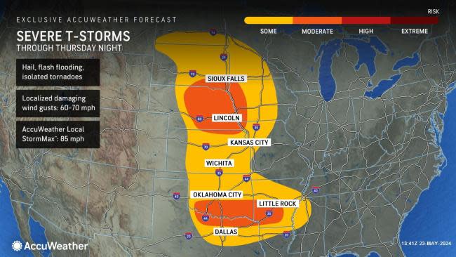
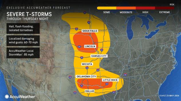
The zone from northern Texas through southern Oklahoma and Arkansas will continue to be the hotbed of thunderstorm development in the short term. AccuWeather meteorologists have put a "moderate risk" of damaging thunderstorms in much of this area for a second period from Thursday to Thursday night.
Destructive hailstones, flooding downpours, damaging wind gusts and isolated tornadoes are most likely in this corridor, but these hazards can occur throughout the zones highlighted by AccuWeather meteorologists.
 |
Air travel could temporarily come to a halt into and out of Dallas until the stormy weather has safely passed.
GET THE FREE ACCUWEATHER APP
•Have the app? Unlock AccuWeather Alerts™ with Premium+
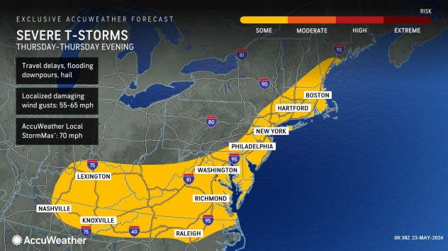
A second zone where severe thunderstorms are anticipated on Thursday and Thursday night will extend along the heavily populated Interstate 95 corridor from Boston through New York City, Philadelphia, Washington, D.C., and on into the Raleigh, North Carolina, metro area, Sosnowski said.
 |
"While widespread severe weather is not anticipated in this zone, any thunderstorm that erupts will have the potential to bring damaging wind gusts, hail and flash urban flooding. As the storms approach the major airports during the afternoon, ground stops are possible. Airline delays will mount and may linger into the evening, with the most likely time for schedule disruptions from noon to 7 p.m.," Sosnowski explained.
A broad area of drenching, gusty storms is likely at the end of the week as millions of Americans hit the road for Memorial Day weekend.
The metro areas of Dallas, Nashville, Cincinnati and Chicago are among the cities where motorists should anticipate heavy enough downpours from Friday to Friday night that can reduce visibility, create ponding and slow travel.
 |
A greater concentration of severe thunderstorms will occur in and surrounding Chicago in northern Illinois, northwestern Indiana, southwestern Michigan and southeastern Wisconsin.
Some secondary roads may become blocked by downed trees or power lines as a result of gusty winds in thunderstorms.
The rounds of thunderstorms, regardless of severity, impacting some of the same areas repeatedly will elevate the risk of dangerous flash flooding.
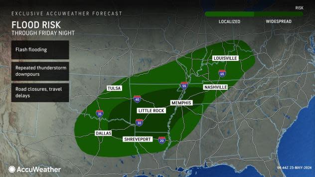
"Through Friday night, a corridor from the Arklatex to the Mississippi, Tennessee and Ohio valleys will experience heavy rain, which can total more than 6 inches in some areas," Glenny said.
 |
The excessive rain, falling over ground that is already saturated in some cases, can result in rapidly rising small streams that can lead to road closures and flooded parks, backyards and basements.
AccuWeather meteorologists encourage those in the central United States with outdoor plans over the extended holiday weekend to remain wary of lingering lightning dangers, severe weather hazards and rounds of heavy rainfall as storm after storm sweeps over the Rockies and onto the High Plains.
 |
In rinse-and-repeat fashion, the area from Dallas to Little Rock will again be in the crosshairs of potentially damaging thunderstorms late Saturday into Saturday night. The area where numerous severe thunderstorms are likely will extend from northeastern Texas to much of central and eastern Oklahoma.
There is the potential for a large complex of thunderstorms to develop on Saturday evening. If so, that system and more regional severe weather may push eastward across Arkansas and southern and central Missouri late Saturday night.
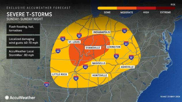
By Sunday, severe thunderstorms in parts of the area from Arkansas and Missouri eastward to southern West Virginia, the Virginia Panhandle and western North Carolina. If the large complex of thunderstorms forms from Saturday evening, it may continue to roll eastward with a concentrated zone of severe weather into the mid-Mississippi and lower Ohio valleys.
 |
"Flash flooding, frequent lightning strikes and wind gusts strong enough to knock down trees will be the main threats to travelers and those spending time outdoors from the mid-Mississippi Valley to the southern Appalachians on Sunday," Sosnowski said.
On Memorial Day, the severe weather risk will return to part of the I-95 corridor from South Carolina to southern New England.
 |
Holiday parades, ceremonies and cookouts could be at risk on Monday.
Want next-level safety, ad-free? Unlock advanced, hyperlocal severe weather alerts when you subscribe to Premium+ on the AccuWeather app. AccuWeather Alerts™ are prompted by our expert meteorologists who monitor and analyze dangerous weather risks 24/7 to keep you and your family safer.
