Massive winter storm moves in as South prepares for heat wave
A massive winter storm is on its way to wreak havoc on a large swath of the country while the South prepares for a record February heat wave.
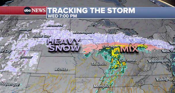
Blizzard warnings are in effect for Montana, Wyoming, Colorado, the Dakotas and Minnesota. Up to 2 feet of snow is possible in the upper Midwest, from South Dakota to Minnesota to Green Bay, Wisconsin.
MORE: 7 things to know before driving in the snow
A winter storm warning was issued in Minneapolis, where the city is bracing for a potentially historic snowstorm. Minneapolis is forecast to get up to 2 feet of snow, which could be a top-five storm for the city.
As forecasts predict up to 20 inches of snow, I’ve directed state agencies, including @MnDPS_MSP, @MnDOT, and @MNNationalGuard, to take steps to prepare.
We're working to ensure we’re ready – and Minnesotans have a part to play, too. Plan ahead, drive safe, and limit travel.
— Governor Tim Walz (@GovTimWalz) February 21, 2023
Public Works is working to prepare for another significant, slow-moving, multi-day snowstorm.
We encourage everyone to start planning ahead and alter plans where possible. We also encourage residents to proactively move vehicles off the street and off-street if available. https://t.co/MHsz7UAA8W
— City of Minneapolis (@CityMinneapolis) February 21, 2023
That map says IMPOSSIBLE TRAVEL and includes parts of I-94 through the twin cities. Gusts to 50 mph on top of all that snow… bulk of it is Wednesday night through Thursday. @SamWnek@Wx_Maxpic.twitter.com/qdDU6j3f6C
— Ginger Zee (@Ginger_Zee) February 21, 2023
A winter storm warning is also in effect for Salt Lake City, where 20 inches of snow is possible Tuesday and Wednesday.
By Wednesday morning, snow will be falling across the central Rockies, including Salt Lake City and Denver.
In the Ohio Valley, a wintry mix could cause an icy commute on Wednesday.
MORE: Will the Texas power grid survive the next deep freeze?
Meanwhile, severe thunderstorms with heavy rain and damaging winds are forecast from Oklahoma City to St. Louis on Wednesday.
By Wednesday night, the heavy snow and blizzard conditions will continue from the Rockies to Minneapolis to Michigan.
A blast of snow and wintry mill also move into the Northeast Wednesday evening, striking New York, Pennsylvania, New Jersey and southern New England.
Late Wednesday night through Thursday morning will be the worst of the snowstorm for Minneapolis.
Here's a look at road conditions in far western Minnesota just before noon today. Snow will continue to spread eastward through this evening. You can monitor road conditions from @MnDOT at https://t.co/1fatflqrOT and @WisDOTnorthwest at https://t.co/9YIfBQ2X9l#mnwx#wiwxpic.twitter.com/EPtm6dnztI
— NWS Twin Cities (@NWSTwinCities) February 21, 2023
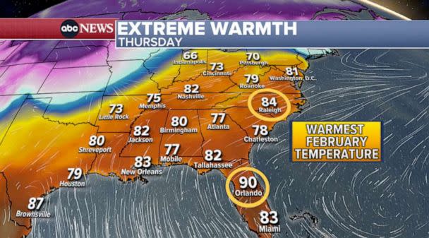
Meanwhile, a record February heat wave is expected from Florida to Washington, D.C.
In New Orleans, this will be one of the warmest Mardi Gras in recorded history. The temperature on Tuesday is forecast to reach 79 degrees. The warmest Mardi Gras ever clocked in at 83.

On Thursday, temperatures are forecast to jump to 83 degrees in New Orleans, 82 in Nashville and 84 in Raleigh, North Carolina.
D.C. could reach 81 degrees on Thursday. That’s only happened three times in the winter in recorded history.
In Orlando, it could reach a sweltering 90 degrees on Thursday, which would be the city’s all-time warmest February temperature.
Massive winter storm moves in as South prepares for heat wave originally appeared on abcnews.go.com
