Beaufort County under gale, hazardous weather advisories as winter storm pummels US
As blizzard conditions, whipping winds and record-breaking low temperatures threaten the majority of the United States, Beaufort County won’t be spared in what meteorologists are calling a “once in a generation” winter storm.
Moving east across the nation, the storm — dubbed Winter Storm Elliot — has already pushed temperatures to frigid levels in the West and blanketed the Northern Plains in snow. It was set to hit the Midwest on Thursday in the form of high winds and heavy snow, upending holiday travel plans. It’ll grip the South on Friday, plummeting the temperature to below-freezing.
Many parts of the country will experience a “bomb cyclone,” or rapidly intensifying storm.
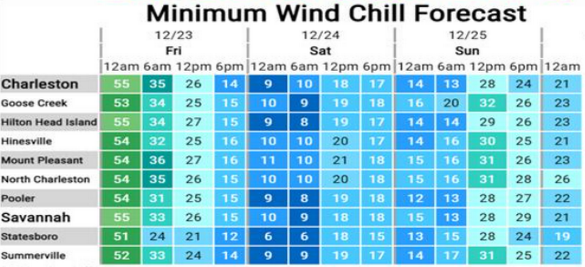
While the Lowcountry won’t see snow or have to deal with negative-degree temperatures, wind chill readings of zero to 10 degrees are possible Friday night into Saturday morning, according the National Weather Service’s hazardous weather outlook. The region’s waters are also under gale watch through Friday evening, meaning west winds could gust up to 35-40 knots with seas building up to 4-8 feet.
Over 100 million people, or about a third of the nation’s population, are under winter and wind chill alerts, according the National Weather Service. For the central U.S., this marks the coldest Christmas in decades, CNN reported.
Those traveling for the holidays have already felt the ripple effect of the winter storm. About 1,700 flights were canceled Thursday, according to Flightaware, a flight tracking website. On Thursday morning, one departing flight, headed for Chicago out of the Savannah/Hilton Head International Airport, was canceled.
But on Friday evening, when a bone-chilling 21 degrees will set in and multiple feet of snow will have piled across the U.S., holiday travel to and from the area may get even more complicated.
Cold temperatures and wind chill will continue Saturday night into Sunday morning, the NWS Charleston office noted. Saturday will see a high of 34, with Christmas Eve temperatures dropping down to 22 degrees. And on Christmas Day, the temperature will rise slightly to 39. On Monday, the high will climb to 45.
With below-freezing temperatures and the potential for strong wind gusts, people staying in Beaufort County for the Christmas weekend need to prepare.
Shelters to open
At the top of the safety and preparation list before the bitter-cold sets in, two shelters — one in Bluffton and the other in Beaufort — will open to community members who need a warm place to stay.
The Sea Island Presbyterian Church in Beaufort will open its doors Friday through Sunday, starting each evening at 5:30 p.m. until 8:30 a.m. The church is located at 81 Lady’s Island Drive.
Dinner, showers and a free breakfast will be provided, according to the church’s Facebook page. Weapons, alcohol, smoking and pets are not allowed. However, service animals can be brought in.
The Bluffton Martin Luther King (MLK) Observance Committee will open the Rotary Club at 77 Shults Road to the public seeking warmth from Friday beginning at 5 p.m. through 9 a.m. The committee plans to evaluate need with the possibility of keeping the shelter open until Monday morning.
Cots, blankets, sleeping bags, coffee, hot cocoa and meals will be provided, the MLK Committee’s Facebook page noted. It’s still in need of bottled water and snacks, and donations may be delivered to the Rotary Club at 3 p.m. Friday.
“The folks who most need this support may not have access to social media and will be relying on word of mouth to learn about these critical and time-sensitive resources,” said Fred Leyda, director of the Beaufort County Human Services Department. “Cold temperatures can be life-threatening for folks without shelter or heat.”
Care for pipes
Extreme cold has the potential to cause pipes to bursts with little warning, the National Weather Service said. The Beaufort-Jasper Water and Sewer Authority said “property owners are responsible for maintenance of water service lines from the meter to the home, as well as any in-home pipes.”
Frozen water lines typically happen in places such as crawl spaces or along the outside walls where uncovered plumbing is more vulnerable to freezing weather.
If a pipe breaks and a customer cannot isolate the leaks during repairs, the authority said it can turn off water at the meter, but charges will apply. However, BJWSA cannot make repairs beyond the meter box. Once the leak is fixed, call 843-987-9200 to report the leak and ask about a potential billing adjustment.
To avoid frozen pipes, the authority suggests the following:
Leave a pencil-thin stream of water flowing from the faucet.
Disconnect and drain outdoor hoses.
For under-the-sink pipes, leave the cabinet door open. Insulate pipes/faucets in unheated areas.
Other preparations
▪ The NWS Charleston office urges people to bundle up with layers if you have to go outside, check on elderly family or neighbors who need extra blankets, help winterizing their homes or a warm place to stay.
▪ Don’t forget that cats and dogs need to be brought inside, especially at night when the temperature drops below freezing.
▪ Make sure to check the anti-freeze in your car.
▪ As below-freezing temps grip the county, plants will need to be covered to keep them warm at night or they can be brought inside. Citrus plants are particularly affected by cold weather.
