Hurricane Lee rapidly intensified from Cat 2 to Cat 5. What the forecast shows
Hurricane Lee rapidly intensified from a Category 2 storm into a Category 5 storm on Thursday over the open Atlantic, then back down to a Category 4 Friday morning — but it could get even stronger over the next few days.
“Additional strengthening is forecast today,” the National Hurricane Center said in an advisory Friday morning. “Fluctuations in intensity are likely over the next few days, but Lee is expected to remain a major hurricane through early next week.”
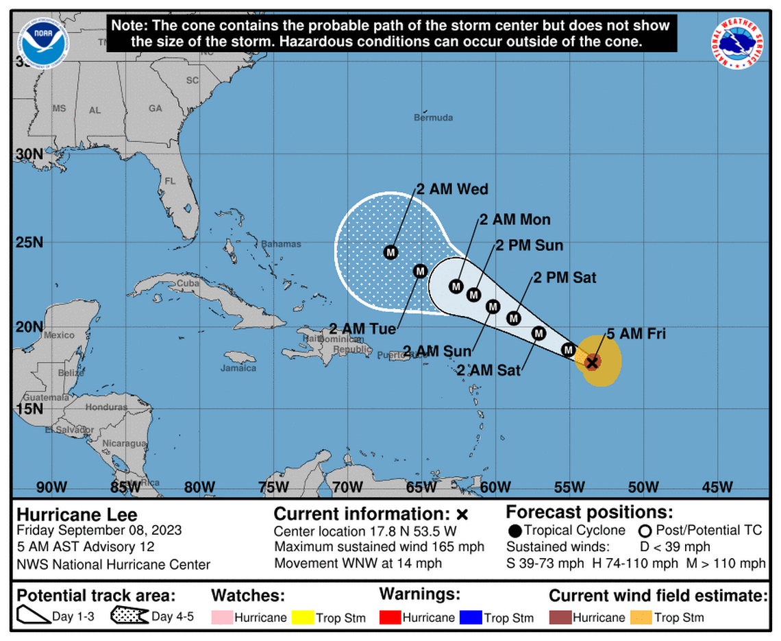
The latest forecast takes the eye of the already formidable storm west across the Atlantic over the weekend and early next week but keeps it well north of the Caribbean islands. The National Hurricane Center only forecasts a storm’s track out five days, when Lee is expected to be hundreds of miles north of Puerto Rico.
But long-range forecast models continue to predict that Lee will take a northern turn as it approaches the East Coast of the U.S., keeping it well away from landfall or any direct impacts. Any Lee-related impacts, including rough surf, wouldn’t be felt until late next week.
READ MORE: What happens when hurricanes rapidly intensify and how is that affecting Lee?
Megan Borowski, senior meteorologist for the Florida Public Radio Emergency Network, said a turn is more likely to happen than not, but Floridians and anyone who lives along the coast should keep watching the storm just in case.
“It’s still got a long way to go over open waters and things can change,” she said.
Hurricane Lee forecast
Hurricane Lee was strengthening at “an exceptional rate.” It jumped from 105 mph maximum sustained winds Thursday morning to 165 mph sustained winds by Friday morning, officially meeting the definition of rapid intensification. Early Friday, the hurricane center had big swing projections for how strong Lee could get — potentially up to 180 mph sustained winds.
But by the 11 a.m. update, the hurricane center had backed off those predictions and moved Lee down to a Category 4.
Lee could descend from that peak over the next five days as it moves west across the Atlantic, although the latest forecast continues to call for Lee to remain at least a major Category 4 hurricane the entire time.
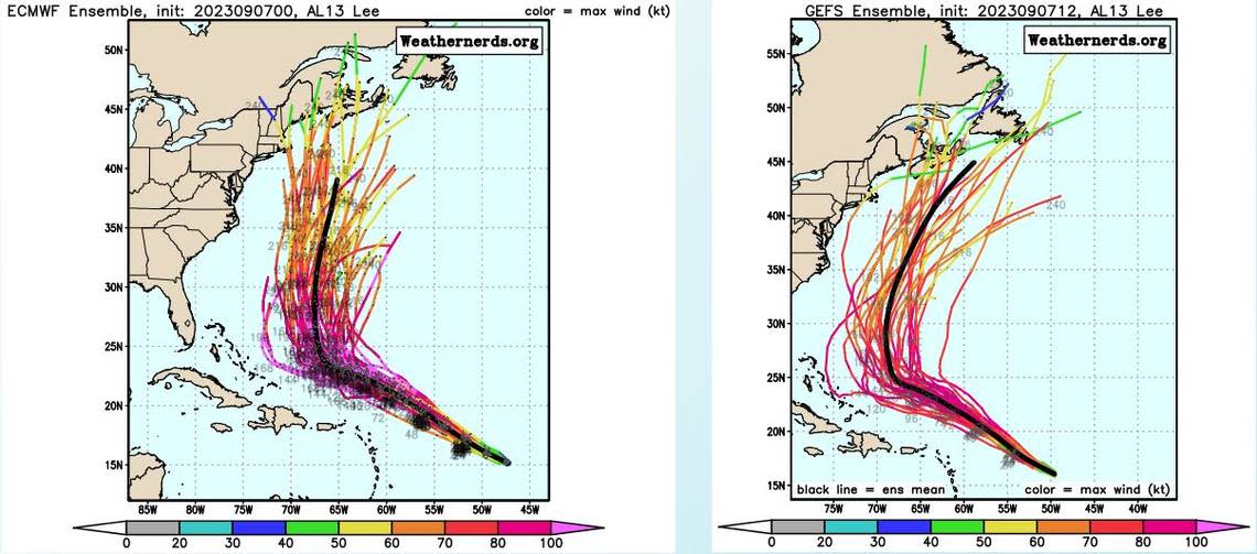
Forecasters said they’re confident in the forecast track for the next five days, which keeps Lee well away from the northern Caribbean islands. After that, when longer range and less certain models suggest Lee could turn north, the hurricane center said the future isn’t set in stone.
“There is uncertainty in any northward turn of Lee beginning early next week, but it is too soon to speculate about specific potential impacts a week or more out,” they wrote Thursday evening.
As of Friday morning, long-range models have been very consistent with predicting a northern turn for the storm, although they differ slightly in the timing. Most suggest that Lee could begin its turn in the middle of next week, with some calling for Tuesday and others shortly thereafter.
Hurricane conditions
Even from hundreds of miles away, Lee still could bring dangerous conditions to the East Coast in the form of rough surf and dangerous riptides.
In Puerto Rico, which could see an inch or two of rain from Lee’s outermost bands, officials warned residents to watch out for rough seas over the weekend and next week as Lee passes hundreds of miles to the north.
“Sea conditions will deteriorate rapidly between Saturday and Sunday, and they will continue to be dangerous during the rest of next week,” said Ernesto Morales, warning coordination meteorologist at the National Weather Service in San Juan. “At sea, especially in the north and east areas, we will see waves between 10 and 15 feet, so we don’t want anyone going to the beach.”
Hurricane Lee advisory
As of the 11 a.m. Friday update, Lee was about 565 miles east of the northern Leeward Islands, with maximum sustained winds at 155 mph. It was headed west-northwest at 13 mph and its hurricane-force winds extended 35 miles out from the center. Its tropical storm force winds extended up to 140 miles from the center.
Miami Herald staff writer Omar Rodríguez Ortiz contributed to this report.
