60% of California in ‘extreme’ drought or worse to start July, federal monitor says
The first nine months of the 2022 water year are now in the books, and California remains mired in extreme drought conditions.
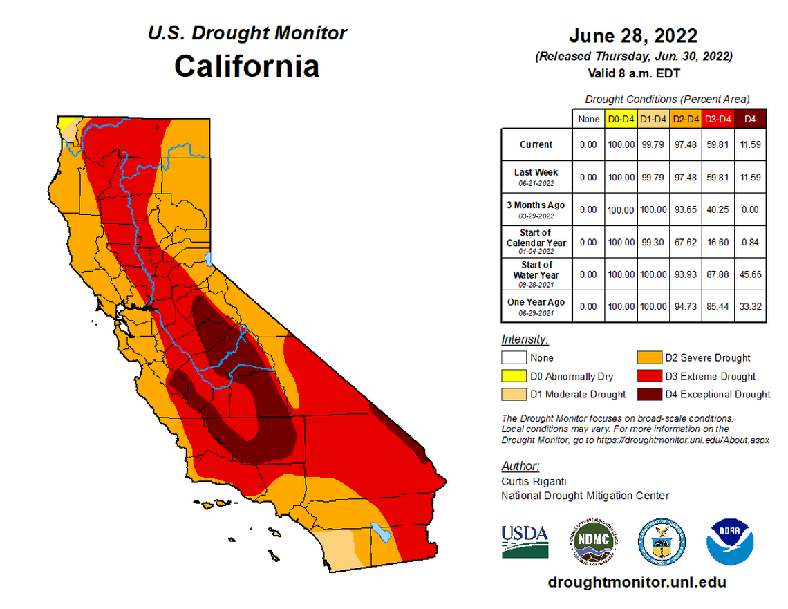
More than 97% of the state’s land area is in at least “severe” drought status, 60% in at least “extreme” drought and the driest 12% in “exceptional” drought, according to a weekly update Thursday from the U.S. Drought Monitor.
Extreme drought encompasses the entire Central Valley, with exceptional drought covering wide swaths of the San Joaquin Valley, according to the federal monitor.
While the latest numbers are slightly better than at the outset of this water year, which started Oct. 1, there had been early optimism that record-setting weather late last calendar year would help avert a third straight year of drought.
A series of October storms including a monstrous “bomb cyclone” system brought the rainiest day ever recorded in Sacramento, and winter storms led the central Sierra Nevada range to smash an all-time record for December snowfall.
More than six months later, those storms have continued to buoy California’s precipitation totals for the current water year deceptively close to average. Abysmal rain and snow totals from January through March, combined with late-spring and early-summer spurts of extreme heat, have evaporated much of the drought relief from last fall and winter.
Sacramento, for instance, stood at 83% of average rainfall for this water year as of the end of June, according to figures updated Thursday by the National Weather Service. Of the 16.4 inches that have fallen this water year, just 2 inches have come since Jan. 1.
Snowpack melted to zero in the southern Sierra by May 24 and in the central Sierra by June 3, according to the California Department of Water Resources. The historic average snow-water equivalent for each of those dates in their respective regions is close to 10 inches.
Only two of the state’s 17 major reservoirs were at or above their historical average levels for the end of June, while eight others – including California’s largest, Shasta Lake – were below 60% of average.
Taking a look at current interior Northern California reservoir storage, Shasta Lake water storage is at 39% of capacity. Oroville is at 49% of capacity, Bullards Bar 88%, Folsom 84%, New Melones 33% and Don Pedro is at 65% of capacity. #CAwx #CAWater pic.twitter.com/6opYwEEKAM
— NWS Sacramento (@NWSSacramento) June 29, 2022
Wildfire weather takes hold
A few strong storms in April and May helped the snowpack hang on while also keeping fire fuels from drying out as early as anticipated, delaying the start of California’s wildfire season by a few weeks.
But fire season is now in full swing, in both Northern and Southern California.
The Rices Fire burning this week in Nevada County injured at least seven firefighters and prompted evacuation orders before crews curbed forward progress at just over 900 acres.
Water cutbacks, orders as drought continues
Gov. Gavin Newsom in late May called for local agencies to voluntarily conserve water usage, but has stopped short of ordering mandatory cutbacks for urban water districts.
The State Water Resources Control Board ordered the city of San Francisco as well as irrigation districts in the San Joaquin Valley to stop pulling water from the Tuolumne River in early June.
The state made the same order for the Tuolumne last year due to drought, but not until August.
