National Weather Service issues Coastal Bend Flash Flood Watch as heavy rain nears region
Note: This story was updated at 11:04 p.m. on Jan. 23.
The National Weather Service issued a Flash Flood Watch for the Coastal Bend and said to expect the possibility of heavy rain and thunderstorms popping up overnight in Corpus Christi and throughout the region.
An updated NWS forecast downgraded slightly the potential impact of the coming storms to the Corpus Christi area, dropping rain chances from 90% to 80%.
Shortly after 8:30 p.m. in an updated report forecasters called for showers "and possibly a thunderstorm, mainly before 4 a.m., then a chance of showers and thunderstorms after 4 a.m. Some of the storms could produce heavy rain."
New rainfall amounts between three quarters and one inch may greet the region by sunrise, when storms are expected to continue with heavy rain possible until at least 10 a.m., then picking up again later through Wednesday night
Look for patchy fog starting tonight and continuing tomorrow morning in the region.
“Showers and thunderstorms will increase in coverage later this evening through Wednesday morning as near record moisture interacts with mid-level disturbances,” the Weather Service said in its flood watch statement. “Latest model guidance highlights the potential for training of showers and storms over the Coastal Plains where soil moisture is already saturated (over 50%). Creeks and streams are already rising from upstream and will be more reactive to additional rainfall."
NWS radar at 11 p.m. showed heavy storms rolling through the San Antonio area and some precipitation moving in the area of Alice.
Rain is moving in overnight
Things were forecast to ramp up in the overnight hours "with showers and thunderstorms before 4 a.m.,” the new forecast stated.
The NWS said some of those storms could produce heavy rain where they occur and there may be patchy fog after 9 p.m. as the mercury drops to around 65 with an east southeast wind dropping to 6 to 9 mph.
Showers and thunderstorms "are likely, mainly before 11 a.m.," the updated forecast stated. "Some of the storms could produce heavy rain. Patchy fog before 4 p.m., then patchy fog after 5 p.m. Otherwise, cloudy, with a high near 74."
The updated forecast rated the chance of precipitation at 60% Wednesday. "New rainfall amounts between a tenth and quarter of an inch, except higher amounts possible in thunderstorms." There’s a 60% chance of rain bringing “between a tenth and quarter of an inch, except higher amounts possible in thunderstorms,” NWS said in its forecast.
More storms Wednesday night
Look for a 40% chance of showers and thunderstorms Wednesday night with patchy fog before 1 a.m., then mostly cloudy with a low around 57 degrees and a north wind around 8 to 10 mph.
On Thursday, the NWS says cloudy skies should become mostly sunny with a high near 72 and a north wind reaching 7 to 9 mph.
This forecast was issued at 8:35 p.m. Tuesday with data from a station 2 Miles NW of Corpus Christi International Airport.
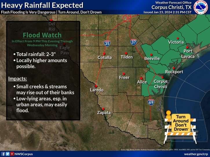
Flash Flood Watch
The NWS Flash Flood Watch Starts at 9 p.m. and expires Wednesday morning. It covers Aransas Islands, Bee, Calhoun Islands, Coastal Aransas, Coastal Calhoun, Coastal Kleberg, Coastal Nueces, Coastal Refugio, Coastal San Patricio, Goliad, Inland Calhoun, Inland Kleberg, Inland Nueces, Inland Refugio, Inland San Patricio, Kleberg Islands, Nueces Islands and Victoria.
“Excessive runoff may result in flooding of rivers, creeks, streams, and other low-lying and flood-prone locations,” the warning states. “Creeks and streams may rise out of their banks. Flooding may occur in poor drainage and urban areas.”
Go to https://forecast.weather.gov/MapClick.php?lon=-97.52287379420221&lat=27.797932191333885 for NWS updates as the situation develops.
This article originally appeared on Corpus Christi Caller Times: NWS issues Coastal Bend Flash Flood Watch as heavy rain nears region
