National Weather Service confirms 6 tornadoes touched down during severe storms in Ky.
The National Weather Service has confirmed that six tornadoes touched down in Kentucky during Thursday’s powerful thunderstorms.
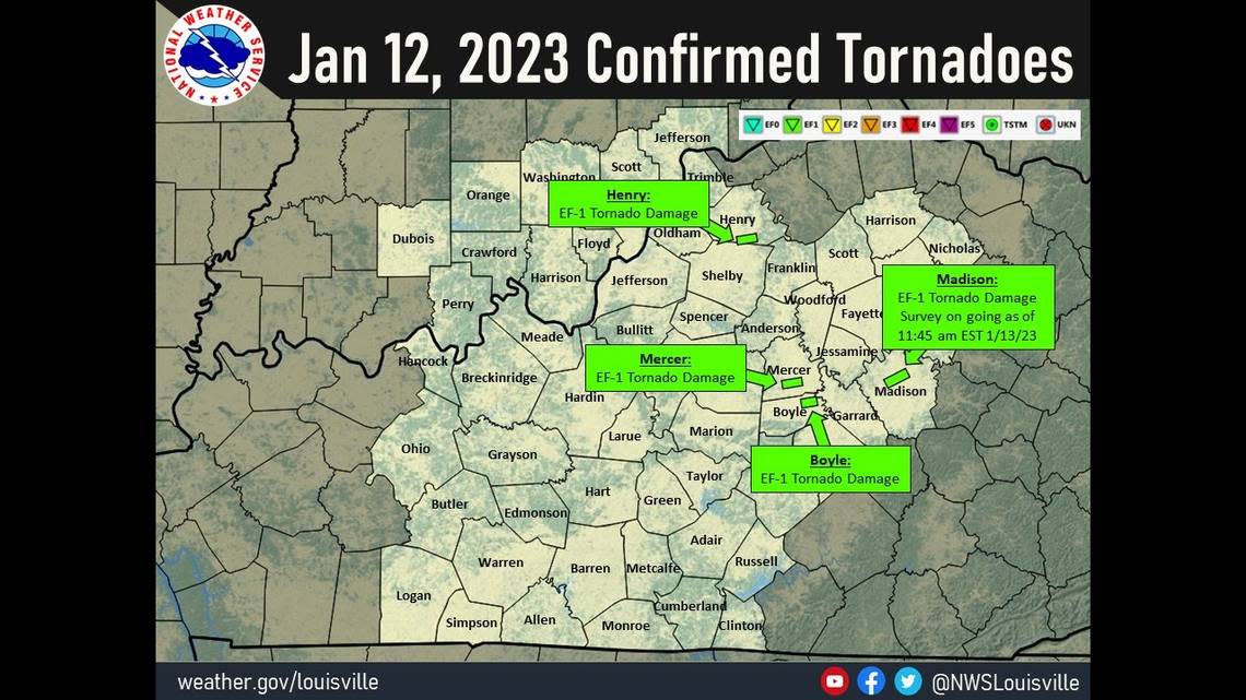
The tornadoes were in Ballard, Boyle, Grant, Henry, Madison and Mercer counties, according to the NWS. The tornadoes had peak wind speeds between 85 and 110 miles per hour, although damage assessment in Madison County was ongoing Friday so wind speed reports were preliminary. The tornado in Henry County had the highest wind speeds at 110 miles per hour.
Some of the tornadoes did cause significant damage to nearby structures. Heather Long, a Mercer County resident on Cornishville Road whose house suffered damage in the tornado, said she was at work when the storm swept through and returned home to see the damage Thursday morning.
“My neighbor actually called me and wanted to make sure that we weren’t home because she was concerned because we also have two small children,” she said.
She returned home around 9:20 a.m. to find “pretty extensive” damage, she said.
“We’ve completely lost everything inside our garage,” she said. “We’re going to have to replace siding, we’re going to have to replace our roof, so it’s done quite a bit of damage.”
Long said it was “devastating to see,” but she was thankful no one was home at the time and said the community had already been very helpful.
Ballard County tornado was first to hit Kentucky
The first tornado that touched down was in Ballard County at approximately 2:03 a.m., according to the NWS. The tornado started in northern Ballard County and ended southwest Massac County in Illinois, traveling 6.7 miles.
The NWS said the tornado was an EF-1 on the Enhanced Fujita Scale and had a max width of 200 yards.
The NWS conducted a damage survey which revealed a tornado path across northern Ballard County, KY to southwest Massac County, IL. The EF-1 tornado occurred around 2:03 AM Thursday and tracked 6.7 miles, with a max width of 200 yards. Roofing and siding damaged on a few homes. pic.twitter.com/Q3Oi2mQKz7
— NWS Paducah, KY (@NWSPaducah) January 13, 2023
Henry County tornado destroys barns
The second tornado that hit Kentucky was in Henry County, according to the NWS. It touched down at 8:47 a.m. and traveled approximately 1.27 miles in two minutes.
The NWS said the tornado, an EF-1, first touched down on a farm about a mile west of Pleasureville along Hillspring Road. The structural integrity of the barn was compromised and a nearby shed was completely removed from its foundation and destroyed.
The tornado continued east across Hillspring Road to another farm where a barn was completely destroyed. Debris from the barn was thrown 100 yards away to the east, according to the NWS.
The tornado continued east another mile into the town of Pleasureville along Williams Street and Main Street, according to the NWS. Surveyors believe the tornado likely dissipated just to the east of homes damaged along Main Street in Pleasureville.
The tornado reached peak wind speeds of 110 miles per hour and had a max width of 100 yards, according to the NWS.
Mercer County tornado lifted before it reached a school
The EF-1 tornado in Mercer County touched down at approximately 9 a.m. and traveled roughly 2.25 miles in two minutes, according to the NWS.
The tornado first touched down on a farm on the south side of Cornishville Road. The NWS said it picked up intensity in the 1900 block of Cornishville Road, causing significant roof and gutter damage to two homes.
the NWS said the tornado became more intermittent as it went towards east/northeast Mercer County. Two bleachers were flipped at Kenneth D. King Middle School near the tennis courts but the tornado lifted before hitting the school.

The tornado had estimated max wind speeds of 100 miles per hour and a max width of 75 yards, according to the NWS.
The Mercer Area Family Education and Wellness building also suffered damage to its roof but none of the staff and children present when the storm hit were injured. Debrah Pierce, the CEO and office manager at Mercer Area Family Education and Wellness said they hid in a safe place, used sleeping mats to cover their heads and played games to keep the children calm.
“They were sequestered in a safe place and we had just gone over all of our emergency drills on Monday before this occurred Thursday,” Pierce said. “We were prepared.”
Live updates: 6 tornadoes reported in Kentucky. Light snow follows severe storms
Boyle County tornado uprooted trees
The EF-1 tornado that hit Boyle County touched down at approximately 9:10 a.m., according to the NWS. It stayed on the ground for roughly one minute and covered less than a mile.
The tornado first touched down near the intersection of Tibbs Lane and Waterworks Road, according to the NWS. A garage suffered significant damage and several trees were topped, snapped and uprooted.
A house on Waterworks Road experienced significant tree damage, including an enormous crater created by the uprooting of two large trees, the NWS said. The owners of the house reported 15 seconds of deafening noise, with pine cones hitting their house from multiple directions.
The tornado lifted up at Dix River, according to the NWS.
The tornado had estimated max wind speeds of 95 miles per hour and a max width of 125 yards, according to the NWS.
Grant County tornado had lowest wind speeds
The EF-0 tornado that hit Grant County touched down at approximately 9:23 a.m., according to the NWS. It was on the ground for roughly one minute and traveled less than a half-mile.
Surveyors believe the tornado first touched down at a residence along Arlington Court, where part of the roof was removed. The NWS said the tornado then moved east/northeast across Arnie Risen Boulevard, where a tree was downed and a street sign was bent to the ground.
The tornado eventually uplifted after hitting a steel warehouse building just east of U.S. Route 25, according to the NWS. A large steel cross beam was bent from the apparent roof uplift. It’s believed the tornado was at its strongest when it hit the warehouse, reaching wind speeds of 85 miles per hour, the NWS said.
The tornado had an estimated max width of 50 yards, according to the NWS.
An EF0 tornado has been confirmed today near Williamstown, KY. More information can be found here: https://t.co/XAOBnFzXXC
— NWS Wilmington OH (@NWSILN) January 13, 2023
Officials still assessing damage from Madison Co. tornado
Damage assessment was still going on in Madison County as of 11:45 a.m., but initial assessments determined that an EF-1 tornado hit the area. Damage consistent with 100 mile per hour winds was found in northeast Richmond.
1215pm EST update - another day of storm surveys this time in Madison Co. KY - preliminary data has EF-1 damage est. 100 mph winds has been found NE of Richmond, KY. Survey is on going and will have more updates through the afternoon. #KYwx https://t.co/D190uiV4wf pic.twitter.com/jXkePmcqLl
— NWS Louisville (@NWSLouisville) January 13, 2023
