Mega temperature rebound in store for the eastern half of the US


A noteworthy warmup is underway for more than 150 million people in the southern and eastern United States, and it will last through the weekend, AccuWeather meteorologists say. The warmup follows the coldest air and the first snowflakes and snowfall for some since this past spring and late winter.
Outdoor plans, such as football games in addition to travel, should go on without any major hitches from Mother Nature in most areas this weekend.
 |
Many people will be able to shed long sleeves and winter coats for light jackets and sunglasses. Some may even feel just fine during the midday and afternoon hours with shorts and short sleeves.
From the pit of the chill on Wednesday and Thursday morning to the peak of the afternoon warmth this weekend, temperatures will rebound 25-50 degrees Fahrenheit in many locations.
For example, temperatures in Atlanta bottomed out at 34 on Wednesday morning but will recover to the mid-70s by Sunday afternoon, which is about 7 degrees above the historical average.
 |
An even more significant rebound is in store for cities such as Nashville and Houston, after lows in the upper 20s and mid-30s on Thursday morning, respectively.
Highs in Nashville are projected to be in the mid-70s on Sunday and the upper 70s on Monday, when it could challenge the record for the date of 79 set in 1915. In Houston, afternoon temperatures will surge into the low 80s on Sunday and the mid-80s by Tuesday and Wednesday. By early next week at both locations, the positive temperature turnaround will be close to 50 degrees.
 |
Farther to the northeast, in New York City, following a cold start at 35 F on Thursday morning, highs both days of the weekend will be in the low 60s, making for a 25-30 degree temperature rise. There's even an excellent chance that New York City will snap its streak of rainy weekends, currently at eight. Conditions will be "nearly ideal" for the New York City marathon on Sunday, according to AccuWeather forecasters.
Temperatures in Philadelphia and Washington, D.C, bottomed out with lows of 34 on Thursday morning, and both locations will experience a rebound with highs well into the 60s on Sunday and Monday. By then a rebound of 30-35 degrees will have occurred. Temperatures will warm even further on Tuesday, with both locations making a run at the 70 degree mark.
 |
However, in the zone from the Upper Midwest to upstate New York and central and northern New England, the temperature turnaround will be much less dramatic.
Following a low in the upper 20s on Wednesday morning, temperatures in Chicago rebounded on Thursday to an afternoon high in the upper 50s. Friday saw similar temperatures, and, as clouds and spotty rain drift through the region on Saturday and Sunday, little upward progress in temperature is likely with highs ranging from the mid-50s to near 60.
 |
Farther to the northwest, along Interstate 94, Minneapolis will experience highs ranging from the upper 40s to the mid-50s through the weekend.
And 1,100 miles farther to the east, Boston, will experience a similar plateau of the warmup due to cloudy intervals with highs in the mid-50s to near 60 through Sunday.
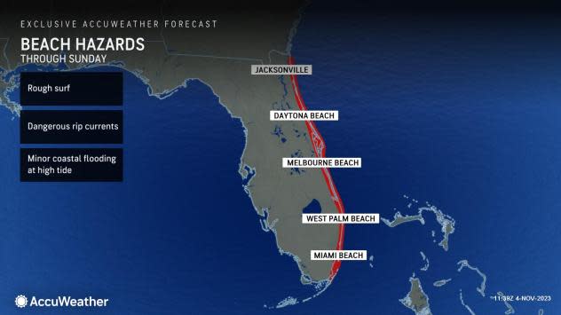
One area where daytime temperatures will remain fairly steady will be across the Florida Peninsula.
 |
A stiff north-to-northeasterly breeze will funnel moist air in from the Atlantic, which will promote clouds and periodic showers. Most of the showers will be along the east coast of the state into Saturday night with some improvement possible on Sunday. The same conditions will create rough surf and strong rip currents for swimmers. High temperatures in Melbourne, Florida, each day through Tuesday will be within a couple of degrees of 80.
While many may welcome the warmer and dry conditions, drought is becoming more of a problem in the Southeast as moisture-laden storms continue to avoid the area. In many locations from Tennessee to Alabama, Georgia, the Carolinas and Virginia, drought conditions have worsened over the past couple of weeks and have remained at extreme to exceptional levels in much of Louisiana and Mississippi.
 |
As the autumn progresses and more leaves come down on dormant brush, the fresh, dry fuel is highly susceptible to catching fire. There have been active wildfires in recent weeks in the South that have not only made the air smoky but combined with fog in some locations. Deadly pile-up crashes occurred when morning fog combined with wildfire smoke in southern Louisiana to create dangerous travel conditions on Monday, Oct. 23.
Forecasters urge extreme caution when using outdoor power equipment, grills and open flames, avoiding parking over high brush as the hot exhaust system can ignite a fire, and never tossing burning cigarettes on the ground.
Later next week, a more progressive and typical pattern for November will set up across the northern half of the nation. Fast-moving storms and fronts will only allow moderate warmups and cooldowns. Warm and mainly dry conditions will likely hold on across the South with potentially worsening drought conditions from the Mississippi Delta to the Southeast states.
While a small short-term boost in water levels will occur over the lower half of the Mississippi River into next week, water levels are likely to decline once again toward mid-November with the potential for more record low water levels to follow this winter.
 |
Low water levels on the Mississippi River have greatly restricted barge traffic on the waterway, which is an economical way to transport commodities, driving up transportation costs.
Want next-level safety, ad-free? Unlock advanced, hyperlocal severe weather alerts when you subscribe to Premium+ on the AccuWeather app. AccuWeather Alerts™ are prompted by our expert meteorologists who monitor and analyze dangerous weather risks 24/7 to keep you and your family safer.
