Live updates: Texas crews responding to at least 10 active wildfires Thursday
Texas firefighters continue containment efforts on at least 10 active wildfires on Thursday morning, the largest being the Chalk Mountain Fire in Somervell County covering over 6,500 acres.
On Wednesday, the Texas A&M Forest Service responded to 10 new wildfires that burned 408 acres. Firefighters also continued suppression efforts on several carryover wildfires, according to the Forest Service.
Temperatures approaching record or near-record highs of 110 degrees, combined with a relative humidity near 20% and 10-mph winds gusting to 20 mph, rebuffed efforts to contain the fires’ spread amid drought conditions, the Forest Service said.
Increasing clouds on Thursday are expected to keep temperatures several degrees lower than on previous days, the National Weather Service reported. Scattered showers and storms are possible north of I-20, not near some wildfires like the Chalk Mountain Fire close to Glen Rose.
No injuries have been reported in the fires, but over two dozen homes and other structures have been destroyed.
Chalk Mountain Fire
The Chalk Mountain Fire was estimated to be 6,339 acres with 10% containment as of Thursday morning.
Texas A&M Forest Service started its response to the Chalk Mountain Fire, 4.6 miles outside of Glen Rose in Somervell County, on Monday when the fire was burning about a thousand acres. That number almost tripled overnight from Monday to Tuesday.
The Chalk Mountain Fire burned almost 10 square miles of mostly short grass, brush and juniper as of midday Wednesday, the Texas A&M Forest Service reported. Sixteen homes were destroyed and five others were damaged, said spokeswoman Alexandra Schwier.
Officials said there was no threat to the nearby Comanche Peak Nuclear Power Plant.
Dinosaur Valley State Park closed Tuesday due to the nearby wildfire.
Embers from burning tree crowns were flying up to 200 yards, officials said.
Nearby Hood County said it would announce any evacuation orders over its emergency notification system and send sheriff’s deputies door-to-door. Those outside the evacuation area will receive a secondary notification through the same system and will also be notified on the county’s Facebook page.
A flight restriction has been placed over the area of the fire to protect firefighters engaged in aerial efforts to fight the fire as well as those on the ground.
The Somervell County Expo Center is open and available for residents affected by the fire with food and sleeping arrangements, according to the Texas A&M Forest Service. FM 205 from CR 1008 to FM 51 is closed due to fire activity in the area.
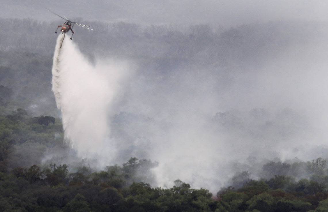
Ninety firefighters worked around the clock Wednesday focusing on protecting structures and digging a containment line around the fire’s northeastern leading edge. Airdrops of fire retardant began Wednesday morning with a special DC-10 called a very large air tanker and two MD-80s called large air tankers dropping 60,000 gallons of retardant near that leading edge by midafternoon, Schwier said.
Palo Pinto County fire
The Palo Pinto County fire, also known as 1148 Fire, was 500 acres with 45% containment as of Thursday morning.
Wednesday night crews found a lot of heat next to containment lines, the Forest Service reported. Firefighters continued to make progress Thursday.
Crews initially responded to the Palo Pinto County fire Monday afternoon, which set several homes ablaze and covered an estimated 500 acres. The forest service said the wildfire, called the 1148 Fire because it was burning near FM 1148, was 15% contained as of Wednesday.
— Tyler George (@TyGe86) July 18, 2022
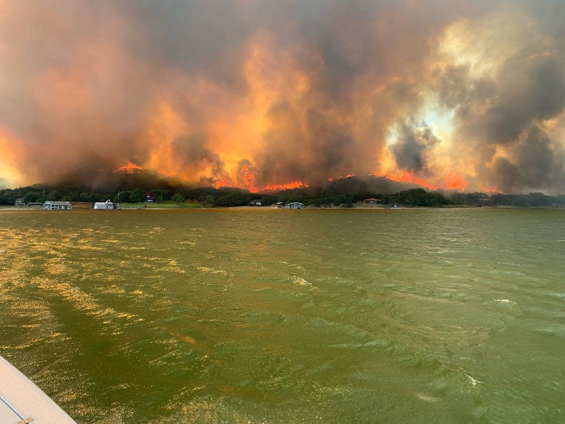
The Palo Pinto County fire impacted Possum Kingdom Lake, about 80 miles west of Fort Worth, prompting evacuations and burning homes on the lake shore.
Authorities said five homes and five other structures were destroyed.
Sandlin Hill Fire
Texas A&M Forest Service reported the Sandlin Fire in Parker County, west of Fort Worth, was 172 acres and 95% contained Thursday afternoon.
Firefighters responded to the Parker County wildfire on Wednesday. Officials said dozers built a containment line around the entirety of the fire and it was patrolled and monitored overnight.
Hood County fire
The River Bottom 2 Fire in Hood County started Wednesday and was at 150 acres and 40% contained as of Thursday morning.
King Creek Fire
On Thursday, the Texas A&M Forest Service reported the King Creek Fire in Kaufman County, east of Dallas, was 458 acres with 100% containment.
The King Creek Fire was initially 100 acres and 50% contained when crews responded to the fire on Sunday afternoon.
East County Fire
Texas A&M Forest Service responded to a wildfire in Kaufman County, east of Dallas, on Tuesday afternoon.
By Wednesday evening, the East County Fire remained an estimated 500 acres and was 60% contained. A fireline was completed near the east side of the fire and dozers were lined to the west side of the fire. Engine crews patrolled and checked for hot spots.
As of Thursday, the East County Fire was 403 acres and 100% contained. Officials said all state resources were released and fire management was transitioned back to the local unit
Stanifer Branch Fire
The Texas A&M Forest Service announced Thursday morning that the Stanifer Branch Fire in Bosque County, about 80 miles south of Fort Worth, was 160 acres and 100% contained.
Bosque County and surrounding areas were placed in a red flag warning for extreme fire danger Tuesday and Wednesday, according to the Bosque County Office of Emergency Management.
Another fire in Bosque County, the Hard Castle Fire, started on July 6 and was contained 10 days later, Texas A&M Forest Service reported.
West Bend Fire
Forest Service crews responded to a wildfire in Wichita County on Tuesday afternoon which was initially estimated to be 400 acres with no containment.
By the evening, the West Bend Fire was estimated to be 3,500 acres with 15% containment. The fire was resistant to control at times as dozers worked to construct containment lines, according to the Forest Service.
As of Thursday morning, the West Bend Fire was 6,522 acres with 98% containment.
State response
On Tuesday, Gov. Greg Abbott directed the Texas Division of Emergency Management to coordinate a statewide response to active wildfires in collaboration with the Texas A&M Forest Service.
“The State of Texas remains steadfast in our ongoing coordinated response to help Texans and communities affected by or at risk of wildfires,” Abbott said. “As we continue to deploy all available resources in response to widespread fire and drought conditions, Texans are encouraged to remain vigilant and weather-aware to protect themselves and their loved ones from dangerous wildfires.”
On July 16, Abbott issued a renewed wildfire disaster declaration which allowed the use of all state government and political subdivision resources necessary to cope with the disaster.
Texas Game Wardens assisted in evacuations alongside first responders during the wildfires in Palo Pinto County. The Texas Game Wardens are part of the Law Enforcement Division of the Texas Parks and Wildlife Department.
The Associated Press contributed to this report.
Current North Texas Wildfires
This map shows wildfires that have been updated within the past 7 days from the Integrated Reporting of Wildland-Fire Information (IRWIN) and the National Interagency Fire Center (NIFC). The larger the circle, the larger the wildfire by acres. Data is from the US Department of the Interior, Office of Wildland Fire, IRWIN, NIFC, NASA, NOAA and ESRI.
