Live updates: ‘Historical’ windstorm blows in. At least 4 deaths; power outages climb.
Editor’s note, March 4: This story is no longer being updated. Visit kentucky.com to find the latest news about this storm.
Gov. Andy Beshear issued a state of emergency ahead of severe weather expected to impact much of Kentucky Friday.
“Today is going to be a dangerous weather day,” Beshear said during a news conference Friday morning. “There is a certainty of severe storms and significant wind gusts, with possibilities of both flooding and tornadoes.”
As a result, the governor said he was calling up the state’s National Guard forces and assembling more than 400 responders should they need to be mobilized.
“They have been advised that we may well need them … They will be ready,” Beshear said.
Kentucky’s Emergency Operations Center has also been placed on higher alert and is now at level 2, an upgrade from Friday morning, Beshear said. That move “should show the seriousness of what we expect,” he added. Non-essential government staff were being sent home early Friday, Beshear said.
This story will be updated throughout the day as new information is available.
Wind advisory issued through 1 a.m.
9:35 p.m. The National Weather Service has canceled the high wind warning that was in effect until 10 p.m. for much of Central Kentucky. It has instead issued a wind advisory through 1 a.m.
The weather service said to expect westward winds of 20 to 30 mph with gusts of 40 to 50 mph.
Blue Grass Airport closed after roof damaged
9:30 p.m. Blue Grass Airport is closing for the evening after sustaining roof damage.
Community Relations Manager Lauren White said incoming flights were rerouted beginning at about 5:30 p.m. because of high winds, and soon after, power went out at the TSA checkpoint. Later, she said, high winds damaged the roof at Concourse A and on the rental car garage.
More than 530,000 without power
9 p.m. More than 530,000 Kentuckians were without power as of just before 9 p.m. KU and LG&E reported more than 219,000 customers without power, including more than 46,000 in Fayette County. Blue Grass Energy had more than 30,000 customers without electricity.
Fayette coroner identifies woman who died during storm
8:30 p.m. The Fayette County coroner has identified a person who died Friday evening as Erica Nichole Yeary, 41, who was pronounced dead in the 1000 block of The Lane at 6:37 p.m. as a result of blunt force trauma injuries to the head.
Earlier, Lexington police Lt. Paul Boyles said a man had gotten out of his vehicle to clear a branch in the road when a tree fell on him and his vehicle on The Lane. A woman inside the vehicle also was seriously injured. He said two people had life-threatening injuries, and one was transported to a hospital.
Three other deaths in storm, Beshear says
8 p.m. Gov. Andy Beshear tweeted that there have been 3 deaths as the storms swept across the state. He said there had been one death each in Simpson, Edmonson and Logan Counties.
“Kentucky, please add one more family to your prayers tonight,” Beshear tweeted. “We just learned of our third weather related death, this loss coming out of Logan County. Let’s continue to be there for one another as we mourn these losses.”
The man who died in Simpson County was hit by a carport picked up by high winds, according to the Simpson County Sheriff’s Office. The sheriff’s office said they responded to 1035 Pilot Knob Rd. at about 1 p.m. and found David Ramsey outside and unresponsive. Attempts to resuscitate him were not successful, and Ramsey was pronounced dead by the Simpson County coroner’s office.
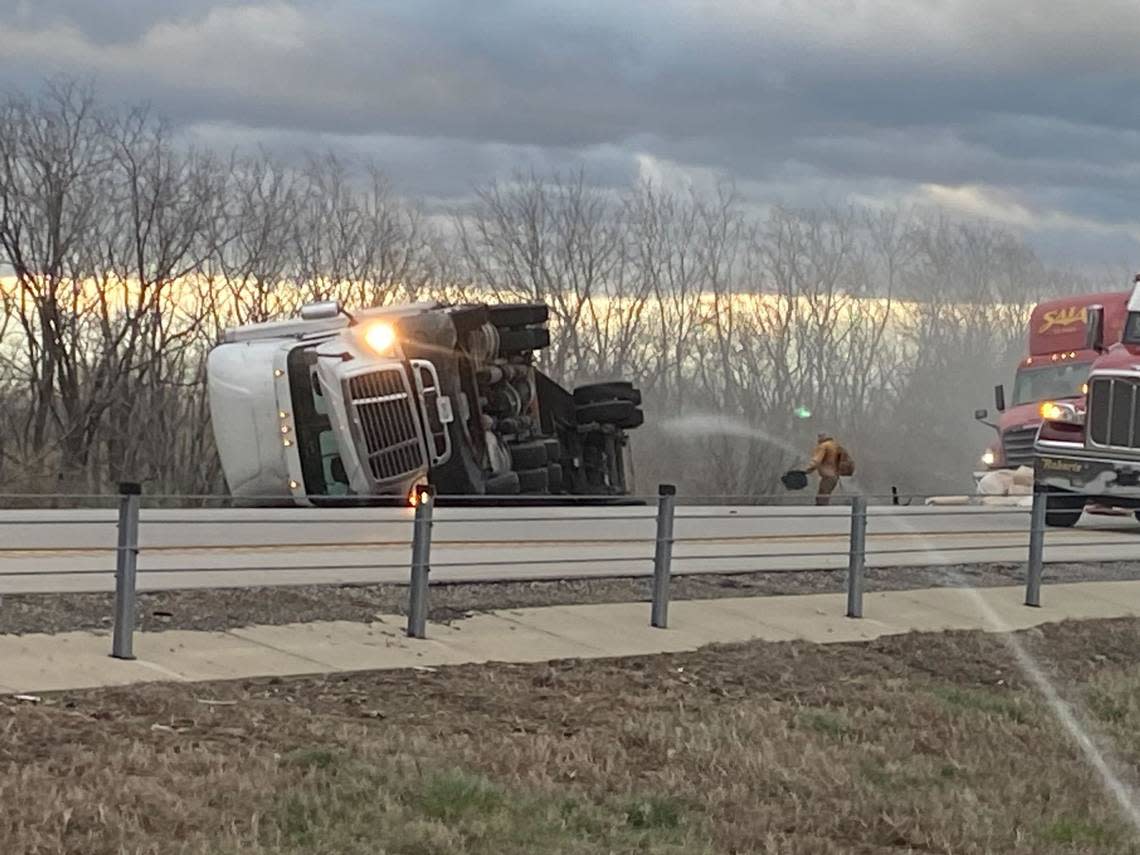
Six tractor trailers tip over, shutting down interstate
7:55 p.m. Lexington police Lt. Paul Boyles said Interstate 64 was shut down beginning at about 5:15 p.m. after high winds caused six tractor -trailers to tip over at the 71 mile marker. Two of the semis were eastbound, and four were westbound.
Boyles said one of them was carrying two adults and four juveniles, and the children were taken to a Georgetown hospital with minor injuries. All lanes of westbound I-64 remained shut down, while one eastbound lane was open. Boyles did not have an estimate for when the interstate might reopen.
“It’ll take a bit to clear,” he said.
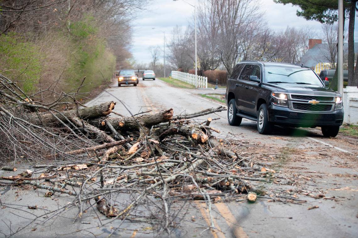
Boyles said downed trees were also impeding traffic on New Circle Road, and emergency crews had responded to “several” reports of trees falling on houses.
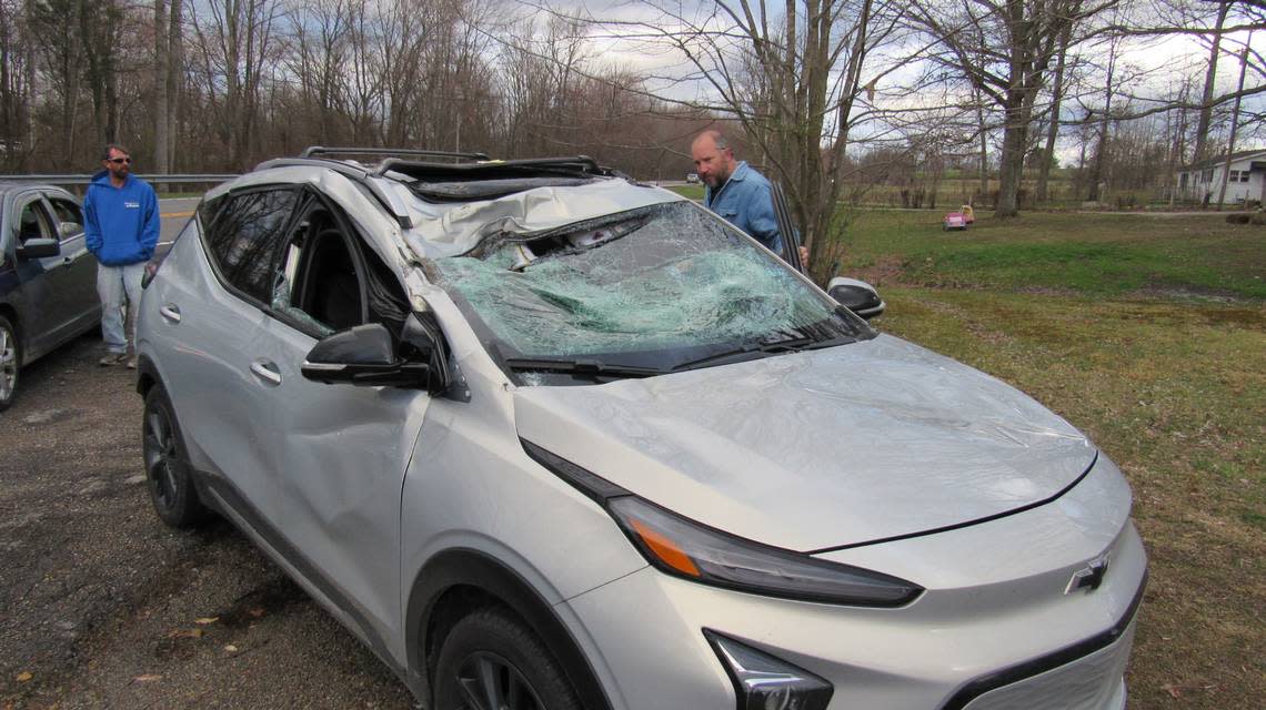
‘Bam!’ Man describes tree hitting his car
7:50 p.m. Steve Hosner was driving in southern Lincoln County Friday about 5:30 p.m. when high wind blew down a tree that struck his 2022 Chevrolet Volt, smashing the windshield and mashing down the top on the passenger side.
Hosner, who had just gotten the car back after an earlier wreck, said he had a bit of a headache after the impact.
“First time I ever had a tree hit me,” he said. “It was like, bam!”
Police respond to 143 weather-related calls
7 p.m. — Lexington police said they responded to 143 weather-related incidents between 1 p.m. and 6:30 p.m. Friday, including five injury collisions, 17 non-injury collisions, 12 calls for citizen or motorist assists and 109 traffic hazards.
WKYT reported that the coroner had been called to The Lane, where a tree fell on a car.
Lexington police Lt. Paul Boyles said a man had gotten out of his vehicle to clear a branch in the road when a tree fell on him and his vehicle on The Lane. A woman inside the vehicle also was seriously injured. He said two people had life-threatening injuries, and one was transported to a hospital.

Fire officials urge people to stay in during ‘historical windstorm’
6:15 p.m. — The Lexington Fire Department said it is “fully engaged with runs throughout the county” and pleaded with residents to stay indoors.
Battalion Chief Jessica Bowman said there were so many reports of downed wires, fire officials are only responding if it is deemed an “immediate life safety issue or fire hazard.”
Otherwise, she said, they are contacting Kentucky Utilities.
“There are numerous trees down throughout the county that are also affecting responses,” she said. “We are obviously going through a very historical windstorm. Stay inside, ride it out, and we can deal with the aftermath when it’s safer.”
She said police and other agencies are also “being taxed right now.”
Part of I-64 closed after winds blow tractor trailers over
6 p.m. — Eastbound I-64 in Fayette County was closed Friday night after multiple tractor trailers were blown over by the high winds, Kentucky State Police said. KSP said to expect delays as they worked to open the roadway.
Near hurricane force winds blow into Lexington
5:20 p.m. — Lexington police were responding to multiple reports of downed trees and power lines as winds that were at times approaching hurricane force hit the area. Power outages in Central Kentucky continued to grow.
The high wind warning was set to continue through the evening.
“Multiple reports in Lexington for trees down on streets and roads,” said a tweet from Lexington’s Division of Emergency Management. “If you can avoid travel tonight, stay inside. The peak windstorm will continue through the evening. Power lines are down as well. Stay away from downed power lines.”
The HIGH WIND WARNING continues. Multiple reports in Lexington for trees down on streets and roads. If you can avoid travel tonight, stay inside. The peak windstorm will continue through the evening. Power lines are down as well. Stay away from downed power lines. #kywx pic.twitter.com/1l8cFvTHf6
— LexingtonKY EM (@LexKYEM) March 3, 2023
Lexington under severe thunderstorm warning
3:25 p.m. — The NWS has issued a severe thunderstorm warning for Lexington, Georgetown and Paris until at least 4 p.m.
Wind gusts up to 70 miles per hour are possible with the storm, according to the NWS.
Severe Thunderstorm Warning including Lexington KY, Georgetown KY and Paris KY until 4:00 PM EST. This storm will contain wind gusts to 70 MPH! pic.twitter.com/ridmN3lL9m
— NWS Louisville (@NWSLouisville) March 3, 2023
Parts of Eastern Kentucky included in tornado watch
3:20 p.m. — The NWS has issued a tornado watch for sections of Eastern and Northern Kentucky.
Boone, Boyd, Bracken, Breathitt, Campbell, Carroll, Carter, Elliott, Fleming, Floyd, Gallatin, Grant, Greenup, Harlan, Johnson, Kenton, Knott, Lawrence, Leslie, Letcher, Lewis, Magoffin, Martin, Mason, Morgan, Owen, Pendleton, Perry, Pike, Robertson, Rowan and Wolfe counties are included in the watch, according to the NWS. It will remain in effect until at least 7 p.m.
A tornado watch has been issued for parts of Indiana, Kentucky, Ohio, Virginia and West Virginia until 7 PM EST pic.twitter.com/IRSeumdq9h
— NWS Jackson KY (@nwsjacksonky) March 3, 2023
McCracken County Judge-Executive declares state of emergency
3:15 p.m. — McCracken County Judge-Executive Craig Clymer has declared a state of emergency for the county after a tornado hit the area Friday, according to WPSD Local 6.
Clymer reported heavy damage to approximately 100 homes in the Freemort area of McCracken County. No major injuries or deaths have been reported.
When is the severe storm supposed to arrive in Lexington?
2:15 p.m. — The NWS has put out a graphic predicting when Friday’s severe storm will hit certain parts of the state.
The NWS forecasts that the severe storm will arrive in Fayette County and other surrounding counties of Central Kentucky between 3 p.m. and 5 p.m. The storm will continue moving towards Eastern Kentucky.
The NWS said damaging winds and spin-up tornadoes are possible.
“If the sun comes out that is actually just fuel for the next batch that is coming,” the NWS said in a tweet.
There are two lines of storms moving into central Kentucky. If the sun comes out that is actually just fuel for the next batch that is coming. #kywx pic.twitter.com/vj1VuLChZ1
— NWS Louisville (@NWSLouisville) March 3, 2023
Fayette County, along with many other counties in Kentucky, are under a tornado watch until at least 5 p.m.
Beshear: Second confirmed tornado in Kentucky
1:10 p.m. — A second tornado in Kentucky from Friday’s severe storm has been confirmed by Beshear.
The second tornado was in Christian County, according to Beshear. The first was in McCracken County.
We have learned of a second reported tornado touching down in Christian County. Please stay safe.
— Governor Andy Beshear (@GovAndyBeshear) March 3, 2023
Noah Bergren, a meteorologist for WPSD Local 6, reported significant damage to churches and homes near Paducah.
Likely tornado damage a few miles SE of Paducah, in the Freemont area of McCracken County.
Some significant damage reported to many homes and churches in the neighborhood.@NWSPaducah @trentokerson pic.twitter.com/dwDMcJlnrc— Noah Bergren (@NbergWX) March 3, 2023
Major damage in SE McCracken County. Hoping everyone is okay. So far, we have not heard of any major injuries. Remember to wear good closed toe shoes when walking in debris after a tornado! pic.twitter.com/vKveDYt5XJ
— Noah Bergren (@NbergWX) March 3, 2023
Large portion of Kentucky under a tornado watch
12:15 p.m. — The National Weather Service has put a large portion of Kentucky, including Fayette County, under a tornado watch.
The watch will last until at least 5 p.m., the NWS said. It also includes parts of Indiana and Illinois.
A tornado watch has been issued for parts of Illinois, Indiana and Kentucky until 5 PM EST pic.twitter.com/vPTpyEOADp
— NWS Louisville (@NWSLouisville) March 3, 2023
Multiple parts of Western Kentucky are under a tornado warning, according to the NWS. Breckinridge, Butler, Hancock, Muhlenberg and Ohio counties are under a tornado warning until at least noon local time while Christian, Graves, Livingston, Marshall, McCracken and Todd counties are under the same warning until at least 11:45 a.m. local time.
A tornado has touched down in McCracken County, according to a tweet from Gov. Andy Beshear around 12:30 p.m.
Today's weather is dangerous. We just had our first tornado reported on the ground in McCracken County. Please be alert and stay safe.
— Governor Andy Beshear (@GovAndyBeshear) March 3, 2023
According to the NWS, a tornado watch is called when weather conditions are favorable to produce a tornado but there is no actual confirmed tornado on the ground. A tornado warning is called when a tornado is occurring or expected to occur shortly.
Do you know the difference between Tornado Watch and a Tornado Warning?
Watch - weather conditions are favorable, be prepared for severe weather.
Warning - a tornado is occurring or expected to shortly. Take action, take cover! pic.twitter.com/se9KuKM5cb— NWS Louisville (@NWSLouisville) March 2, 2023
Governor warns of power outages, wind gusts strong enough to ‘move a tractor trailer’
11 a.m. — Beshear warned of dangerous road conditions Friday, with wind gusts as high as 70 miles per hour.
Much of the activity is expected to begin at noon and continue throughout the afternoon as a fast-moving thunderstorm moves from west to the east across the state.
“This is going to be a prolonged weather event today,” Beshear said, urging the public not to grow complacent after the initial storm passes.
In addition, Beshear said, “We do think there is a real potential for isolated tornadoes” Friday.
Beshear urged the public to return home early today if it’s safe to do so, and called Friday’s school closures the right move.
Pay attention to local forecasts and look for updates from government agencies and the state’s emergency management branches via social media, Beshear said.
City of Lexington, University of Kentucky and others close early
11 a.m. — The University of Kentucky canceled classes after noon on Friday and sent all but essential staff home in preparation for the storms.
UK Healthcare facilities will remain open, university officials said. Campus food services at Champions Kitchen and Fresh Food Company will remain open until 8 p.m. All other dining services closed at noon.
The University of Louisville, Western Kentucky University and Eastern Kentucky University also announced Friday they would be canceling all afternoon classes and events.
Mayor Linda Gorton also sent all non-essential city employees home at noon. Other government offices, including all Lexington Public Library locations, also closed at noon. The early dismissals and closures come after the Fayette County Public Schools canceled classes Friday.
Gorton urged people to stay off roads Friday afternoon during the worst of the potential storms.
“Citizens who can stay home this afternoon should do so. Driving in the high winds that are predicted for Lexington is not safe,” Gorton said.
In addition, the city is also bringing in more emergency responders to help in case of widespread damage and power outages, city officials said.
“Public safety is ensuring proper staffing is available during the projected peak time of the event,” said Susan Straub, a spokeswoman for the city. “This will involve holding some people over and asking others to come early”
