Live updates: Major flooding and power outages hit North Jersey as rainstorm slams region
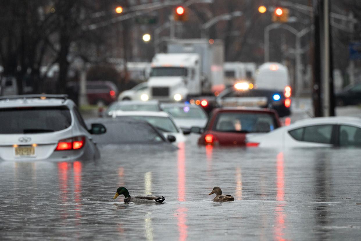
A massive rainstorm that hit Sunday night continued to batter North Jersey into Monday with major flooding and power outages wreaking havoc on the region.
Relief remains many hours away with rain likely through at least the late afternoon as up to 4.5 inches could hit the region.
Flooding shut down highway lanes through the state Monday morning ahead of the prime commuting hours.
Our staff will bring you updates throughout the day on the storm. Here's the latest:
Potential flooding at North Jersey rivers
Several North Jersey rivers were cresting at minor flood stage Monday morning according to USGS stream gauge data. Others won’t reach minor flood stage until Tuesday evening.
The Hackensack River at New Milford was at 6.4 feet Monday morning, above its normal minor flooding threshold of 6 feet. The Hackensack at River Vale was at 6.38 feet, above its minor flooding mark there of 5.3 feet.
The Pascack River in Westwood was at 5.4 feet, slightly above its normal minor flooding stage of 5 feet.
The Rockaway River in Boonton below the reservoir was at 2.9 feet around 8 a.m. Monday. It was expected to surpass its flood action level of 3.5 feet, reaching 3.8 feet by noon.
The Passaic River in Pine Brook was at 18.7 feet Monday morning. It is expected to reach 20.8 feet – above its minor flood threshold of 19 feet – on Tuesday evening.
− James O'Neill
Power outages in North Jersey
The storm knocked out power for thousands of people Monday morning. Some of the outage numbers, by customers served, as of 1:30 p.m. include:
Bergen County: 1,384
Passaic County: 148
Essex County: 429
Hudson County: 84
Morris County: 2,963
Sussex County: 1,976
How much rain has fallen in North Jersey so far
Up to 4-to-5 inches of rain fell in parts of North Jersey. North Haledon and Oakland went over 5 inches, according to Bob Ziff of the North Jersey Weather Observers. See the full list here.
Bergen County rain response
The Bergen County Office of Emergency Management team is on call and stationed throughout the county and working with local law enforcement. The high water rescue task force is also on call and have already been deployed to a water rescue in Hillsdale, where a local evacuation order was put in place, said Derek Sands, deputy chief of staff for Bergen County Executive Jim Tedesco said.
There has been moderate flood damage in some of the county parks reported this morning. “We are aware that this afternoon the tide cycle is on high-tide and there are certain areas that we need to watch out for,” Sands said.
Most of the county has already received 3 inches of rain with another inch expected throughout this afternoon. Excessive runoff is resulting in flash flooding of rivers, small creeks, streams and other low lying and flood prone areas, a bulletin issued by the County OEM said.
Bergen County officials have been in contact with Veolia Water company representatives and all three dams are currently spilling. Since all dams are spilling the rain fall will be passed down stream. There is special attention to the Hillsdale, Westwood, Oradell, New Milford and River Edge area with major flooding expected through Tuesday.
− Kristie Cattafi
Hoboken rain conditions
Hoboken is usually one of the worst hit New Jersey communities when it comes to flooding.
But by 8 a.m., most streets on the city’s flood-prone westside were open. The Hudson-Bergen Light Rail was running on a regular schedule through Hudson County with umbrella-toting commuters tiptoeing past large puddles to catch their train.
Not everywhere was passable. Traffic was halted at Paterson Plank Road in Jersey City Heights due to flooding down the hill in Hoboken.
− Scott Fallon
When will the rain stop?
Rain appears in the forecast until 2 to 3 p.m. depending on your exact spot.
National Weather Service meteorologist James Tomasini expects the rain to slowly taper off through this morning and for North Jersey to be dry by the late afternoon.
As for wind, it will begin to slowly die down. Gusts up to 35 mph may continue through the day and are expected to reduce throughout the night.
“The storm is ongoing, and we are still gathering reports,” said Tomasini. “If you come across any flooded roads, do not drive. Be on the lookout for additional flood or flash flood warnings as the storm continues.”
School closings
West Essex and Lincoln Park are among several schools that closed or had a delayed opening Monday due to the rain.
Mahwah, Allendale and Teaneck flooding
Mayor James Wysocki said township was "hit pretty hard this morning," including several water rescues from flooded cars and "significant water damage." Business Administrator Ben Kezmarsky said flooding occurred in predictable and unusual locales. Power lines are down. Elementary schools had an early dismissal due to a power outage. Trees were down in roadways, and across properties. Many basements were flooded. DPW, Police Department, and Emergency Services were out in force.
Allendale is reporting flooding of railroad underpasses on West Crescent between Myrtle Avenue and West Allendale Avenue, and West Orchard Street between Franklin Turnpike and Allen Street. The area near the entrance to Crestwood Lake on West Crescent Avenue at West Allendale Avenue is also closed due to flooding.
In Teaneck West Englewood at Hudson Road is closed due to down trees and low hanging wires. Windsor Road between Route 4 and West Englewood Avenue is closed due to flooding.
− Marsha Stoltz
North Jersey traffic Closures on I-80, I-287; Routes 46, 3, 94; Devils at Prudential
Hawthorne flooding
At least four sections of road were cordoned off to motorists in a low-lying portion of Hawthorne, said Mayor John Lane.
The 1st Ward is notoriously prone to flooding of Goffle Brook, and Lane said the overnight storm was a “little worse” than previous rain events that the borough has experienced. “It floods all the time,” he said. “The avenue that the brook takes isn’t wide enough to handle all the water.”
Most of Wagaraw Road was closed to traffic, Lane said. And portions of Goffle Road and Rea Avenue were still shut down as of 11 a.m., he said. “One at a time, now, they’re opening up,” he said. “The problem is that there’s a lot of debris in the street.”
It may be hours before the roads are passable. A public works crew was deployed to the flooded streets with a front-end loader to clean up tree branches and other hazards, Lane said.
The brook, a Passaic River tributary, flows under the old textile mill at 179 Goffle Road. Lane said the owner of the building, now a warehouse and a plant for small-batch concrete, has tried to unclog the section of the stream that runs through the 7.3-acre property.
− Philip DeVencentis
Passaic County flooding
In Clifton, one persistent flooding area Clifton Avenue, around the railroad bridge and Anzaldi Recreation Complex had a some significant flooding, which is not unusual. During Tropical Storm Ida, severe flooding damaged numerous properties in area and led the condemnation of medical arts building.
In Passaic, Fire Chief Pat Trentacost reported “major flooding.” The following streets are completely flooded out and are closed: River Driver at Aycrigg Avenue, River Drive at Van Houten Avenue, Pennington Avenue at Benson vAenue, Lafayette Avenue at Route 21, State Street and Route 21 Washington Street at Hope Avenue and Main and Brook avenues.
“High tide is at 12:33 p.m.“ Trentacost said. “We are concerned.”
− Matt Fagan
Morris County storm response
In Morris County, homeowners awoke to soggy basements in parts of Dover, Lincoln Park, Parsippany, Rockaway Township and other communities, as the storm drenched low-lying areas. In the Indian Lake section of Denville, the waters overtopped docks and spilled into the narrow streets around the village.
"We responded into Dover earlier this morning at the request of the Dover Fire Department to assist with a number of flooding related emergencies, people that were either trapped in vehicles or flooding waters,” said Jeff Paul, director of the county’s Office of Emergency Management. “That similar type of event did happen in other municipalities throughout Morris County.”
In Pequannock, the Pompton River had already surged above flood stage at 16.4 feet as of Monday morning and was expected to crest at just below 18 feet after midnight on Tuesday.
Flooding caused intermittent closures of local roads throughout the county, as well as along Route 10 between Whippany and Troy-Hill roads in Parsippany, with the worst conditions reported in northern and western Morris County.
Residents are advised to stay indoors when possible, due to hazards like uprooted trees and standing water, county Sherriff James Gannon said.
"Stay in as much as you can," Gannon said. "There are trees that are just uprooted and have fallen into the roadway and there’s standing water in the streets, you don't know the depth of it."
− Gene Myers
Hackensack flooding
In Hackensack, flooding caused the closure of several roads, including Main Street and Romaine Court, Kinderkamack Road, South Newman Street, Essex Street and Green Street, Lodi Street and McKinley Street, and Main Street and South Lake Drive.
Downed wires have been reported at Club Way and the Esplanade and Ross Avenue near Prospect Avenue, Capt. Michael Antista said.
The Hackensack Fire Department warned people not to drive through flooded areas and avoid unnecessary travel until the flooding subsides.
− Megan Burrow
Sussex County flooding
In Sussex County, Wykertown Road (County Route 629) between Frankford and Wantage is closed.
The National Park Service has closed several roads within the Delaware Water Gap National Recreation Area as well as the length of the Delaware River from Port Jervis at the New Jersey/Pennsylvania/New York border through the water gap.
The river is expected to rise to more than 20 feet as measured at the gauge in Montague by mid-day Tuesday. Flood stage at that gauge site is 25 feet, however low-lying areas and islands within the park may see some floding.
Officials closed River Road between Park Headquarters and the Hialeah Picnic Area just north of the hamlet of Shawnee and advised that Route 209, the main road on the Pennsylvania side of the river could see some flooding from the mountain sides, especially near creek and stream crossings.
In New Jersey, the park has closed Old Mine Road between Millbrook Village and Worthington State Forest. Blue Mountain Lakes Road is also closed until further notice.
− Bruce Scruton
Check back for updates as the storm continues.
This article originally appeared on NorthJersey.com: NJ flooding and rainstorm slam North Jersey with power outages
