LIVE UPDATES: Hurricane Ian rain, wind calming down ‘through the evening’
Hurricane Ian has finally begun leaving the area and storm conditions were calming Friday evening after a hectic day of heavy rain, intense winds and storm surges that flooded many areas.
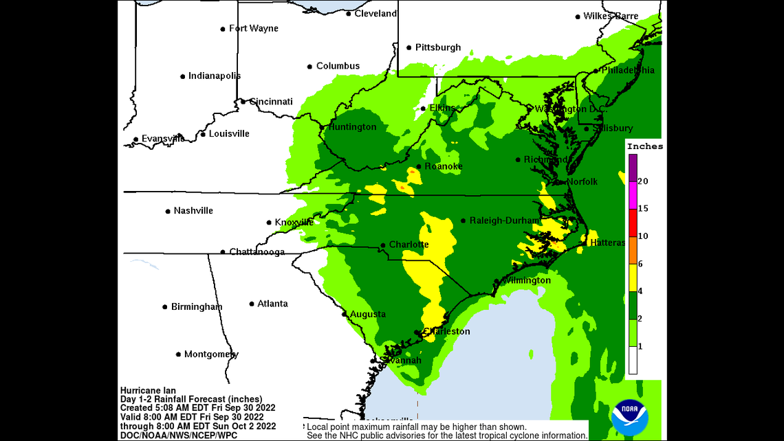
The storm weakened rapidly after landfall, becoming a “post-tropical cyclone” Friday afternoon, according to the National Weather Service. It had 70 mph winds about 20 miles northwest of Myrtle Beach as of 5 p.m. Heavy rain and wind gusts were continuing across the region. However, the tornado threat has “ended across the area,” the weather service said.
With many areas still experiencing significant flooding and dangerous storm conditions, it is still best to stay indoors and not venture out until the storm has fully passed.
5 am EDT Friday, September 30 Key Messages for Hurricane #Ian.https://t.co/gGIui0ts9N pic.twitter.com/oDWIymL6Yn
— National Hurricane Center (@NHC_Atlantic) September 30, 2022
Notable for Saturday
Life will look a little bit differently in the Grand Strand for several days, or even several weeks or months. Here’s some of what you need to know for tomorrow.
Coast RTA, the local bus authority, will be operating alternate routes and in some cases will temporarily stop service until floodwaters recede and debris is cleared. Here are the changes and what’s staying the same.
Route 17 will operate along US 17 throughout North Myrtle Beach until Ocean Blvd is cleared.
Route 14 will have regular service in Georgetown starting at 8:30 a.m.
Route 4 will not have service to the Choppee Road area.
Route 16 will have limited stops. It will depart Andrews at 7 a.m. and will arrive at the Georgetown Transit Center at 7:30 a.m. before heading to Myrtle Beach.
Route 16 service will begins 8 a.m. at the Ivory Wilson Transit Center in Myrtle Beach
Route 1 will pick up its regular schedule at 7 a.m.
If you plan to drive, be careful when heading out as many areas, especially in North Myrtle Beach and areas closer to rivers and the ocean, could still be flooded. Don’t risk driving through floodwaters, as they could be deeper than they look or could be hiding downed power lines that could electrocute you.
Also, these weather advisories remain in place for now.
Coastal Flood Advisory through 6 a.m. Saturday for Brunswick County, N.C..
High rip current risk through 8 p.m. Saturday for Horry and Georgetown counties in South Carolina as well as Brunswick County in North Carolina.
High Surf Advisory until 8 a.m. Saturday for Horry, Georgetown and Brunswick counties.
The recovery begins
UPDATE 8:14 p.m.: Some parts of the Grand Strand are beginning to see calming storm conditions. The Market Common neighborhood of Myrtle Beach briefly saw the sun peeking out of the clouds before steady rain started again.
“Gusty winds and heavy rain continue over parts of the area, but we expect improving conditions through the evening,” National Weather Service meteorologist Mark Willis said in a Friday evening email update on the storm. “Wind gusts of 40-60mph and an additional half inch to inch of rainfall are possible, with isolated higher amounts over the (northwest) part of our area through the evening.”
Many businesses closed on Friday in anticipation of the storm. One of them, Publix, has already announced that it’s five stores in the Grand Strand will reopen on Saturday with normal business hours.
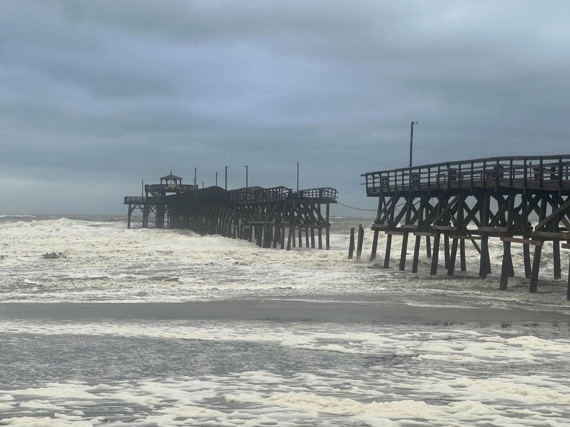
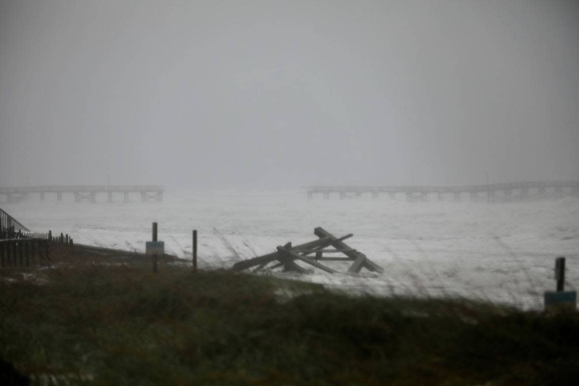
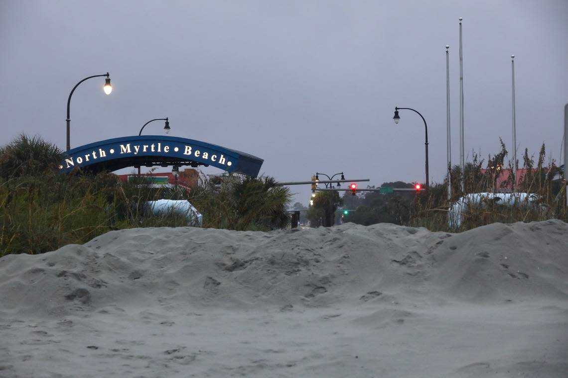
However, many areas are still suffering from the effects of Hurricane Ian. North Myrtle Beach, an area that is particularly low-lying and easily floods during minor rains or high tides, is inundated with water. The Cherry Grove Pier, one of the four damaged by the storm, has been chopped in half. About 30% of the pier stands alone in the ocean without any connection to land.
Recovery can begin soon. “Weekend weather looks favorable for storm recovery and clean up efforts,” the weather service said in a statement Friday.
At about 7 p..m., the Murrells Inlet Marshwalk was almost serene. Dried up reeds washed ashore by the storm coated part of the shoreline, but none of the damage looked permanent or particularly long-lasting
Evacuating the beach
UPDATE 3:30 P.M.: About 100 people camping at the PirateLand Camping Resort on the ocean front in Myrtle Beach had to retreat from their campsites and bring their campers to the parking lot next to the office because one to two feet of water came in.
“We were expecting a lot less because we were expecting the hurricane to go in down by Charleston and Hilton Head, and now it’s come into Georgetown, so we got a lot more of the storm surge than what we thought,” said Terry Walters, the night manager for PirateLand.
Walters added everyone at the site is OK.
The Myrtle Beach Fire Department also had to help people trapped on the second floor of a motel on Ocean Boulevard, the city reported Friday afternoon. Guests are also being evacuated from the Twilight Surf Motel, also on Ocean Boulevard, which lost a portion of its roof, the city said.
A fishing boat also washed ashore in Myrtle Beach near Williams Street, police reported.
“DO NOT GO NEAR THE BOAT. It is EXTREMELY DANGEROUS,” the Myrtle Beach Police Department said in a tweet. “The information we have is that no one is on board. DO NOT GO NEAR THE BOAT.”
A boat has washed on shore near Williams Street. DO NOT GO NEAR THE BOAT. It is EXTREMELY DANGEROUS. The information we have is that no one is on board. DO NOT GO NEAR THE BOAT. @MyrtleBeachFire @MyrtleBeachEM @MyrtleBeachGov pic.twitter.com/QLd8bqhHDM
— Myrtle Beach Police (@MBPDSC) September 30, 2022
Hurricane Ian makes landfall near Georgetown
UPDATE 2:48 P.M.: Hurricane Ian had long been expected to make landfall directly on top of Charleston, but it split the difference between the Lowcountry and the Grand Strand, slamming into the city of Georgetown Friday afternoon.
Georgetown is located about 40 miles south of downtown Myrtle Beach and 60 miles south of Cherry Grove, a North Myrtle Beach neighborhood that has had significant flooding.
Just before the storm made landfall, it took out two of the region’s famous piers, the Cherry Grove Pier and the Pawleys Island Pier, both of which had survived plenty of tropical storms and hurricanes in the past.
Ian made its arrival known well before slashing across South Carolina — cutting power to an estimated 70,000 customers and driving waters over low-lying roads in North Myrtle Beach’s Cherry Grove area.
Update: Surface observations indicate that the center of #Hurricane #Ian made landfall on Sep 30 at 205 pm EDT (1805 UTC) near Georgetown, South Carolina with maximum sustained winds of 85 mph (140 km/h) and an
estimated minimum central pressure of 977 mb (28.85 inches). pic.twitter.com/TNk43VBHUG— National Hurricane Center (@NHC_Atlantic) September 30, 2022
Surfside Beach resident James Whittington posted a photo on Facebook of the Murrells Inlet Marshwalk completely underwater.
Pawleys Island’s pier collapsed, floating south
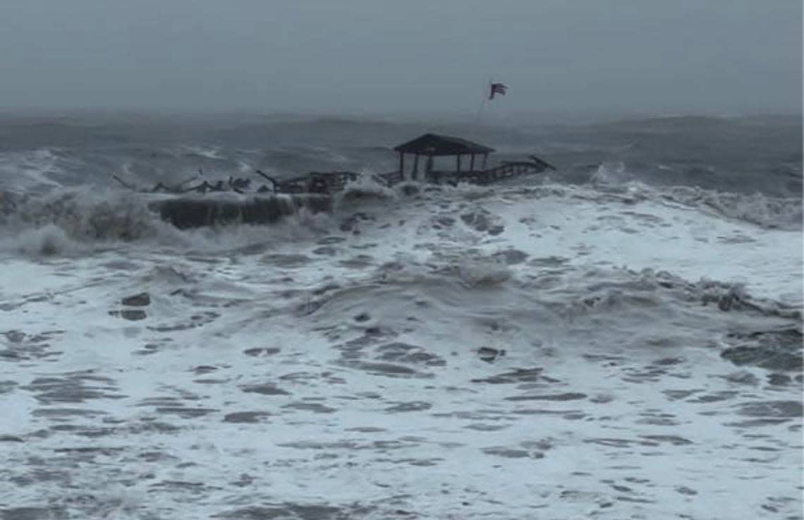
UPDATE 1:35 P.M.: The end of Pawleys Island’s pier collapsed and floated south into the Atlanic Ocean as Hurricane Ian made its powerful approach to South Carolina.
The town’s police department announced the damage via Twitter just before 1:30 p.m. on Sept. 30, shortly before Ian was expected to make landfall.
The end of the Pawleys Island pier has collapsed & is floating south. pic.twitter.com/ajJsWeXWfN
— Pawleys Island PD (@PawleysIslandPD) September 30, 2022
Is Horry County on the ‘dirty side’ of Hurricane Ian?
UPDATE 1:12 P.M.: Like every hurricane, Ian has a dirty side, which, as the name suggests, is a place no one would want to be because it’s usually considered the area with the most threatening weather.
“While any part of a hurricane can be life threatening - we typically see the potential for higher storm surge on the right front side of the storm with respect to its motion.” said Steven Pfaff, a meteorologist with the National Weather Service.
He said that the “dirty side” of the hurricane would impact Horry, Georgetown and Brunswick counties.
Horry County remains under a tornado watch through Friday night
UPDATE 1:08 P.M.: The National Weather Service placed Dillon, Marion and Horry counties under a tornado watch until 10 p.m. Sept. 30.
Communities including Conway, Garden City, Little River, Myrtle Beach, North Myrtle Beach, Red Hill and Socastee are included in the alert.
Myrtle Beach airport, Barefoot Landing are among potential flood-prone areas as Hurricane Ian moves through
UPDATE 12:26 P.M.: The National Weather Service said minor flooding across Horry County has likely already begun or will start around noon, as an additional three inches of rain should continue to soak low-lying areas.
In particular, the following locations are expected to see flooding:
Myrtle Beach
North Myrtle Beach
Georgetown
DeBordieu Colony
Surfside Beach
Pawleys Island
Myrtle Beach International Airport
Little River
Burgess area
Litchfield Beach
Forestbrook area
Barefoot Landing
Wampee
Cherry Grove Beach
Briarcliffe Acres
All areas remain under a flood advisory until 2 p.m.
River flooding estimates released for Myrtle Beach area rivers
UPDATE 11:30 A.M.: The National Weather Service on Sept. 30 released new river flooding estimates that put several in the greater Myrtle Beach area and just across the state line at higher levels.
Springmaid Pier at Myrtle Beach could surpass nine feet by mid to late Friday morning, which is a moderate-level food stage.
The Waccamaw River could jump past nine feet as well, but that keeps it well below its moderate flood stage of 12 feet. Meanwhile, the Little Pee Dee at Galivants Ferry could touch eight feet by Oct. 4, putting it right at flood stage.
Thousands without power in Horry County
UPDATE 11:18 A.M.: As of 10:48 a.m., Horry Electric Cooperative reports 31 outages affecting 2,624 of its 88,840 customers -- most of them in the Aynor area. Santee Cooper is reporting about 46 outages, mostly in coastal areas of the county around Myrtle Beach, impacting 4,019 customers.
Scenes from around Horry County, including Myrtle Beach, North Myrtle Beach and Conway.
UPDATE 10:32 A.M.: It was a quiet morning in downtown Myrtle Beach. There were clouds moving quickly overhead and empty streets as most businesses were closed.
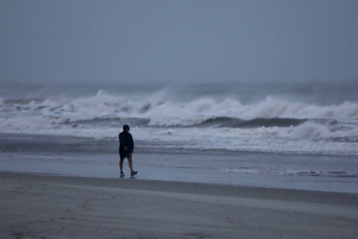
Further up the coast in North Myrtle Beach, several people were found wandering the beach and checking out the surf. The Cherry Grove Pier can be seen in the distance.
Here are the photos from North Myrtle Beach.
In the Socastee community of Rosewood, homes are prone to flood in part due to the proximity to the intracoastal waterway. “It gets pretty nasty, but I’m on Boxwood which never floods,” Alan Coulumbus, a Rosewood neighborhood resident said on Friday morning. “It’s really a nice neighborhood here, it’s just that it floods. I’ve talked to people that have lived here for 40 years and they say its just one flooding after another.”
Check out the photos from Rosewood.
A bakery owner in Conway decided to feed members of the national guard Friday. Owner Marsha Taylor and her staff got up in the predawn hours to prepare boxed meals for about 20 National Guard troops stationed around the state.
“Since we had to make pastries and stuff for them, we decided to stay open for a little bit,” she said. “Everybody can come here and get them a doughnut.”
Businesses near The Pier at Garden City are closed Friday as Hurricane Ian approaches, bringing potential storm surge and flooding.
Here are the photos from Garden City.
Horry County workers built up the sand dunes near public beach access points in the area, partly to discourage people from getting close to the ocean. Water was already pooling onto the streets nearby.
President Biden approves emergency aid for SC
UPDATE 10:03 A.M.: Federal emergency aid has been approved for South Carolina due to the emergency conditions conditions related to Hurricane Ian, according to the U.S. Department of Homeland Security.
“FEMA is authorized to identify, mobilize and provide at its discretion, equipment and resources necessary to alleviate the impacts of the emergency,” the news release states.
Horry County’s Emergency Operations Center will address impacts from hurricane
UPDATE 9:11 A.M.: The county’s Emergency Operations Center will be responding to issues brought on by the storm, according to a news release.
The emergency phone bank is open for any questions or concerns from residents but not reports of emergencies. The number is 843-915-5000.
Morning on the beaches of Horry County, scenes from Myrtle and North Myrtle Beaches
UPDATE 8:56 A.M.: A few people were walking the beach Friday morning in North Myrtle Beach as conditions deteriorated due to Hurricane Ian.
Take a look at photos from downtown Myrtle Beach early Friday morning.
All flights in and out of Myrtle Beach International have been canceled
UPDATE 6:20 A.M.: The Myrtle Beach International Airport shows all arriving and departing flights as canceled for Friday, Sept. 30. For more information, visit the airport website.
More than 3,200 flights across Florida were canceled as Hurricane Ian battered the state, and major airports in cities including Orlando and Tampa remained closed as of Sept. 29.
“If you have vacation plans definitely check with your carriers, check with your hotels,” FAA national operations manager John Lucia said in a Twitter message. “Now might not be the best time to go down there.”
Santee Cooper is reporting five power outages in the Grand Strand
UPDATE 6:12 A.M.: The power company is showing a total of five outages impacting nearly 1,000 customers. Power outages can be reported here.
Here is the advice Santee Cooper gives customers who are experiencing a power outage.
Check your circuit panel or fuse box. If you have circuit breakers, flip the main breaker switch to the “off” position, then back to the “on” position. If you have fuses, check your fuse box and replace any fuses that have blown.
Check the outside disconnect below your meter (not all buildings have an outside disconnect).
Check with your neighbors to see if they have power.
You can report an outage online or call 1-888-769-7688 to report the outage by phone.
Watch these live cams as Hurricane Ian approaches Myrtle Beach and coastal area
UPDATE 6 a.m.: Hurricane Ian is expected to bring heavy rain, strong winds with the possibility of tornadoes and flooding to our area beginning later tonight and continuing through the day tomorrow.
Businesses in the area have live web cam’s so you can check in on the latest and watch as Ian makes landfall in Myrtle Beach and the surrounding areas.
Click here for web cam videos in places around Myrtle Beach.
