Live updates: Second tornado warning in effect until 4:45 p.m.
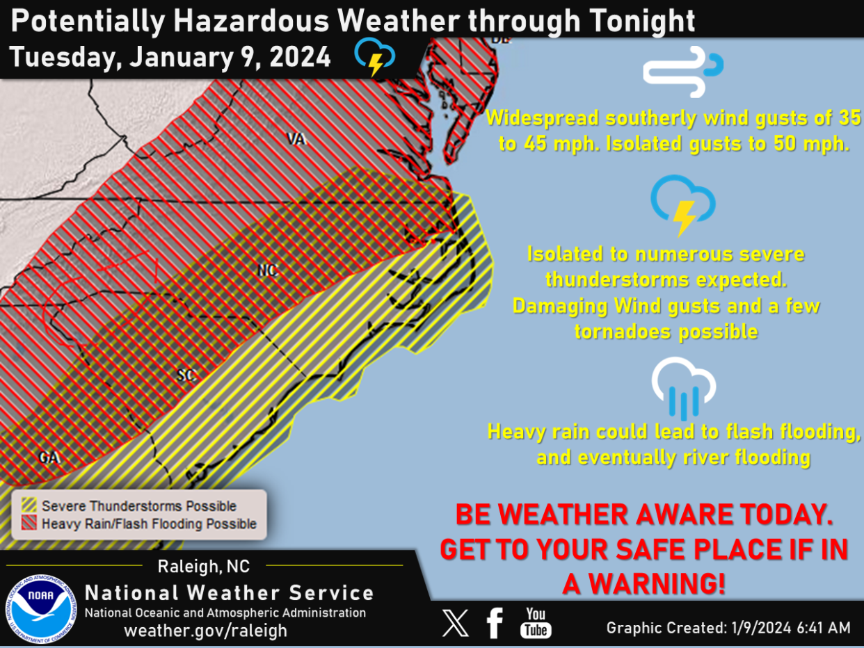
Dangerous storms and severe weather are expected today, with the Storm Prediction Center placing the entire Cape Fear region, which includes Fayetteville, under a Level 3 (Enhanced) risk of severe weather.
A wind advisory is in effect from 10 a.m. to 10 p.m. Tuesday. According to the National Weather Service, south or southeasterly winds will increase to 20 to 25 mph, with 35 to 50 mph gusts in the afternoon and evening. Winds will peak between 2 p.m. and 10 p.m. Tuesday.
Damaging straight-line wind gusts and isolated tornadoes will be possible, and the storms could produce 1.5 to 2.5 inches of rain, according to the NWS. This could lead to flooding.
Gov. Roy Cooper on Tuesday declared a state of emergency ahead of the storms, according to a news release from the governor's office.
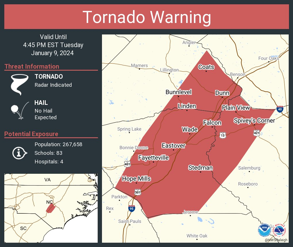
Second tornado warning issued
The National Weather Service in Raleigh issued a second tornado warning at 4:06 p.m. for Cumberland County, southeastern Harnett County and northwestern Sampson County until 4:45 p.m.
At 4:05 p.m., a severe thunderstorm capable of producing a tornado was located over St. Pauls, or 11 miles east of Red Springs, moving northeast at 55 mph, the NWS said.
This dangerous storm will be near Fayetteville around 4:15 p.m. and Godwin around 4:35 p.m.
Other locations impacted by this tornadic thunderstorm include Wade, Hope Mills, Vander, Cedar Creek, and Falcon.
Tornado warning expires
The storm that prompted a tornado warning has weakened below severe limits and has exited the warned area, the National Weather Service announced at 3:58 p.m.
However, gusty winds are still possible with this thunderstorm. A Tornado Watch remains in effect until 9 p.m. for central North Carolina. A severe thunderstorm warning remains in effect for a portion of Harnett County until 4:15 p.m.
Tornado warning in effect until 4 p.m.
A Tornado warning was issued for northwestern Cumberland County, east central Moore County, southwestern Harnett County, south-central Lee County and central Hoke County.
"At 332 PM EST, a severe thunderstorm capable of producing a tornado was located over Raeford, moving northeast at 70 mph," the National Weather Service said.
Other locations impacted by this tornadic thunderstorm include Olivia, Silver City, Spring Lake, Pineview, and Anderson Creek, the NWS said.
The weather service urges people in the affected area to take cove by moving to a basement or an interior room on the lowest floor of a sturdy building. Avoid windows. If you are outdoors, in a mobile home, or in a vehicle, move to the closest substantial shelter and protect yourself from flying debris.

More Cumberland County early closures including city buses
City offices, including Fayetteville-Cumberland Parks and Recreation Centers and Fayetteville Regional Airport Administration offices closed at 2 p.m. Tuesday and the Fayetteville Area System of Transit Center will close at 4 p.m. along with their bus operations, a news release said.
There will also be a delay in solid waste collections. Collections in the following areas will resume Wednesday:
• Household waste collection delay: Devonwood, Valley Forge and Lakeshore neighborhoods.
• Yard Waste collection delay: Arboretum Place, Bryce Creek Lane, Cotton Drive, Alloway Place, Kirkwood Place, Kirkwood Road, Forrest Creek Drive, Overton Place, Baker Street, Shadow Oak Drive, Highgrove Court, and Cliffdale Road in between South McPherson and Morganton Road.
For questions on airport flight schedules, travelers should contact the airline directly.
“I urge everyone to prioritize safety as our city and surrounding community faces a significant risk of high winds and potential for flooding as we face impending severe weather,” Mayor Mitch Colvin said in a 2:15 p.m. update.
City offices and services will resume on regular hours Wednesday
According to the National Weather Services, another storm system may bring additional heavy rain and strong gusty winds Friday night into Saturday.
Fayetteville PWC’s payment drive-thru and administrative offices at 955 Old Wilmington Road have closed for the remainder of the day, PWC announced shortly before 2:30 p.m. PWC’s customer service line (910-483-1382) will remain open during normal business hours and in response to the storm. PWC personnel are on standby to respond to outages and service emergencies, a news release said.
To report outages and emergencies to PWC, call 910-483-1382. Updates are also available through the PWC online outage map Electric Outage Map | FAYPWC.COM : FAYPWC.COM and through PWC social media channels.

Tornado watch in place until 9 p.m.
A tornado watch was issued at 1:45 p.m. for 38 eastern and central North Carolina counties including Cumberland, Hoke, Harnett, Lee, Moore and Sampson counties, according to the National Weather Service.
A fast-moving line of thunderstorms over western North Carolina will track eastward Tuesday afternoon, posing a risk of damaging wind gusts and a few brief tornadoes, the NWS forecast. This line is expected to build northward with time into central and southeast Virginia.
Latest from Chick Jacobs: What to know about the dangerous storm moving into Fayetteville area this afternoon
Cumberland County offices closing early
Cumberland County Government Offices and the Court System will close at 1 p.m. today ahead of the storm, the county announced.
In addition to County offices closing early, the Cumberland County Board of Elections has canceled their meeting scheduled for 5 p.m.
Cumberland County Board of Commissioners Chairman Glenn Adams and Fayetteville Mayor Mitch Colvin released a statement shortly after 1 p.m. urging residents to prepare for the impending storm.
“We want to encourage all of our residents to make the proper preparations for this storm and stay safe as it passes through our area,” Adams said in the release. “You can never truly predict what the impacts will be, but our highest priority is the safety of our residents, and we encourage everyone to take this threat seriously and stay informed.”

Spring Lake state of emergency
Spring Lake Mayor Kia Anthony has declared a state of emergency ahead of the severe weather, according to a news release from the town.
Fort Liberty
Fort Liberty will be on minimal manning Tuesday, the Army installation announced in a news release. Adverse weather employees will be required to report to work as scheduled, but nonadverse weather employees shouldn't report for duty, the release said. Employees should refer to their chain of command for further guidance and instructions.
All of Womack Army Medical Center's outlying primary care, dental and specialty clinics, clinic pharmacies, pharmacy annex, main outpatient pharmacy, elective surgeries and other services are closed Tuesday, the hospital announced.
The Womack Army Medical Center Inpatient services, Fast Track and the emergency department will remain open.
Appointments scheduled for Tuesday will be rescheduled. The outlying primary care clinics, pharmacies, surgeries, and other outpatient clinics will reopen on Wednesday.
The Nurse Advice Line Nurse is available 24/7, call 1-800-TRICARE, Option 1.
Residents asked to help clear storm drains ahead of storm
With heavy rains and winds forecast for the next 12 hours, Fayetteville’s Street Maintenance Division is encouraging residents to remove debris that could potentially block street storm drains to prevent minor road flooding, a news release said. The division maintains more than 16,000 storm drains in the city.
"Leaves, pine straw and other debris around storm drains will prevent proper water flow. By taking a few moments to inspect and clear these drains, residents can significantly contribute to flood prevention and safeguard their neighborhoods during heavy rain," the release said.
Residents are also encouraged to secure trash and recycling carts away from the road.
"This precaution should be taken after collections have been made. Solid waste and recycling are scheduled for normal pickup," the release said.
To receive notifications about severe weather, evacuations, and protective actions, residents should sign up for Cumberland Alerts. The Cumberland Alerts notification system enables Cumberland County’s Emergency Services to provide critical information to residents throughout the county. Residents can sign up by visiting CumberlandCountyNC.gov/Alerts.
Closings
The following closings, cancellations and early releases have been announced:
• The town of Hope Mills will close at noon today, the town announced in a news release.
• Cumberland County Schools will operate on remote learning, and Prime Time Before & After School Program will be closed Tuesday, according to a news release from Cumberland County Schools. All athletic events and after-school activities are canceled or rescheduled. The Cumberland County Board of Education meeting has been rescheduled to 6 p.m. Thursday.
• Fayetteville Technical Community College will close at 2:30 p.m. Tuesday, the college announced in a news release.
More: Weather Permitting: Severe weather in the forecast for Fayetteville area this week
• Moore County Schools will operate remotely Tuesday, according to a news release from the school system. Tuesday will be an optional work day for employees.
• Harnett County Schools will operate remotely, and all extracurricular activities are canceled, the school system said in a news release. It will be a telework day for employees.
• Hoke County Schools are operating on a remote schedule, according to a Facebook post from the school district.
• Moore County government offices will close at noon Tuesday for all nonessential personnel, the county announced in a news release. All Parks & Recreation Department basketball games are canceled Tuesday.
• The Public Schools of Robeson County will be closed Tuesday and operate on a two-hour delay Wednesday, according to a press release from the district.
• Bladen County Schools will operate remotely and all after-school activities are canceled Tuesday, according to a Facebook post from the school district.
• Methodist University is operating on a remote schedule for students, faculty and staff. Only essential personnel will report in person, according to a Facebook post from the university.
Email news@fayobserver.com to report a closing, cancelation or delay.
This article originally appeared on The Fayetteville Observer: Severe weather, storms in Fayetteville, NC: What you can expect
