Live Tallahassee storm updates: Squall line roars through region, spawning tornadoes
A powerful squall line capable of producing of 70-80 mph wind gusts is tearing across North Florida this morning and spawning "extremely dangerous" tornadoes ahead of it.
The line of storms, which spun off a tornado and wind gusts that downed trees and damaged structures in the Panama City and Marianna areas, has reached Tallahassee, according to the National Weather Service in Tallahassee.
The severe weather prompted area schools and courts to shut down for the day. Utility crews in Tallahassee and elsewhere have responded to thousands of power outages, though restoration efforts will temporarily cease as conditions deteriorate. The storm coincides with the first day Florida's legislative session at the Capitol, which was continuing as planned.
First look at tornado damage in Marianna, Florida early Tuesday morning. Buildings were torn apart and mobile homes were tipped over.
The Gulf Coast continues to see tornado threats throughout the morning. pic.twitter.com/yuFOiM8aIt— AccuWeather (@accuweather) January 9, 2024
Follow along for the latest updates:
As squall line passes, Tallahassee Police renew patrols, electric crews get to work
"The peak impact of the storm has passed, and utility crews are resuming restoration efforts," the city of Tallahassee wrote on X. As of 11:45 a.m., almost 15,000 customers were without power, according to the city's power outage map. Talquin Electrical Cooperative, which serves rural communities neighboring Tallahassee, reported that 17,439 of its 55,351 customers were without power. Almost all of Buck Lake, Baker, Wetumpka and Miccosukee were without power.
Police patrols have also resumed as the worst of the storm passed by.
The Tallahassee airport, which reported a top wind gust of 55 mph, was expected to resume operations at noon.
The beat goes on as legislative session opens in Florida with DeSantis' State of the State speech, State of Emergency declaration
In the Florida Capitol, a Tornado Warning could not derail the opening of the state's legislative session.
News Director Jim Rosica, who is in the Capitol, reported that as a chorus of storm-related phone alerts goes off in House chamber, House Speaker Renner pause his speech, then said, "Our business goes on, rain or shine." Then, he added “We’ll stand by for just a minute.” He notified lawmakers they would be advised if they needed to take shelter.
At the conclusion of Renner's speech, Ron DeSantis arrived for the State of the State speech just minutes after heavy rain and winds had the rest of the city sheltering in place.
He opened his speech by noting that every other government building in Tallahassee is closed except for the Capitol. He suggested it was a symbol of the state's resilience and said that he had declared a state of emergency to ensure impacted residents could get assistance.
"We will handle whatever fallout there is from these dangerous tornadoes," he said.
The state of emergency includes 49 counties: Alachua, Baker, Bay, Bradford, Brevard, Calhoun, Citrus, Clay, Columbia, Dixie, Duval, Escambia, Flagler, Franklin, Gadsden, Gilchrist, Gulf, Hamilton, Hernando, Hillsborough, Holmes, Jackson, Jefferson, Lafayette, Lake, Leon, Levy, Liberty, Madison, Marion, Nassau, Okaloosa, Orange, Osceola, Pasco, Pinellas, Polk, Putnam, Santa Rosa, Seminole, Sumter, St. Johns, Suwannee, Taylor, Union, Volusia, Wakulla, Walton, and Washington counties.
Squall line arrives in Tallahassee
Electric crews and Tallahassee Police units are now sheltering in place "due to dangerous conditions" as a dangerous squall line crashes into Tallahassee. About 10,000 customers are currently without power as heavy rains and winds buffet the capital city.
A large swath of the capital city was under a Tornado Warning until 11:15 a.m. A separate tornado warning also exists for Crawfordville and Woodville until 11:30 a.m. Forecasters noted that while they saw a debris signature in western portions of the county near Fort Braden, they could not immediately confirm the touchdown of a tornado.
11:03am ET - The storm possibly containing a tornado has moved through much of Tallahassee but south and eastern portions of Tallahassee and Leon county still under a threat for the next 10 to 20 minutes. #FLwxpic.twitter.com/tGUXqyTHoS
— NWS Tallahassee (@NWSTallahassee) January 9, 2024
Tornado Warning issued for parts of Leon County
A Tornado Warning has also been issued for parts of Leon County. "This potential tornado will skirt northwest portions of Leon county, and likely cross Highway 20 in the next few minutes," NWS forecasters say.
The National Weather Service said severe thunderstorms capable of producing tornadoes, extensive straight line wind damage and quarter-sized hail was moving through the area.
"Flying debris will be dangerous to those caught without shelter," the Weather Service said. "Mobile homes will be damaged or destroyed. Damage to roofs, windows and vehicles will occur. Tree damage is likely."
Tornado Warning including Midway FL, Jamieson FL and Norfleet FL until 10:45 AM EST pic.twitter.com/KX00vht3nC
— NWS Tallahassee (@NWSTallahassee) January 9, 2024
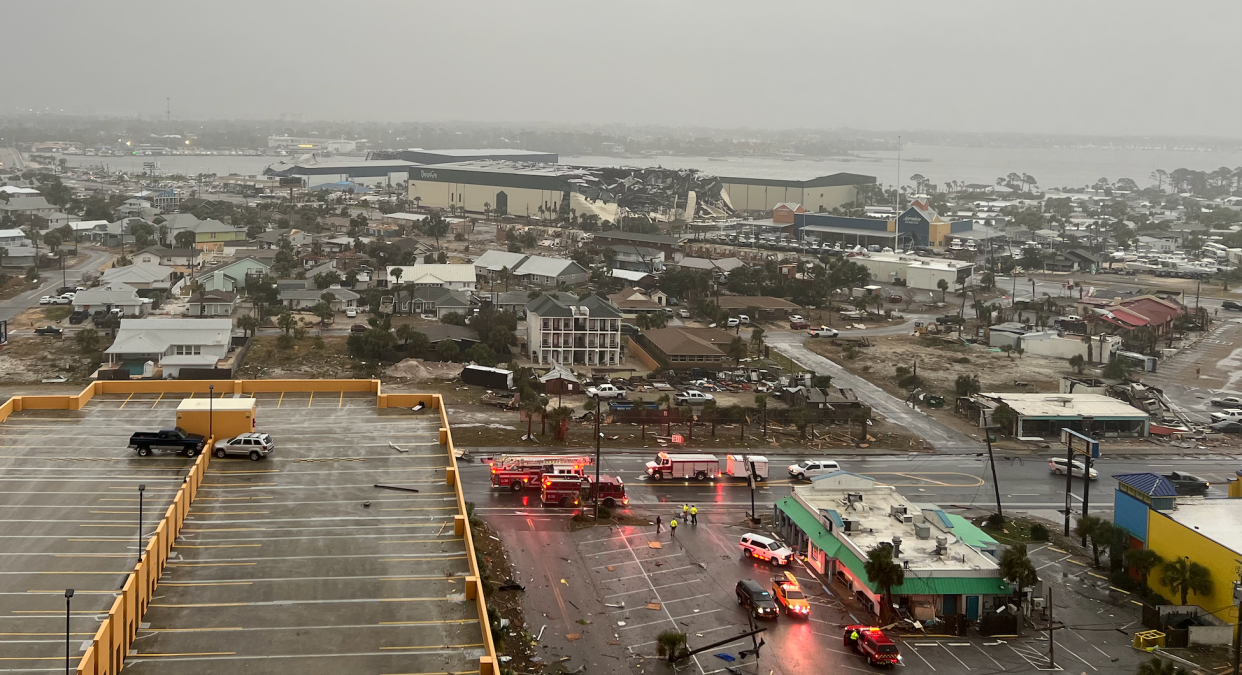
Tallahassee now under a Severe Thunderstorm Warning
As of 10 p.m., we are officially under a Severe Thunderstorm Warning. The National Weather Service issued the warning for a wide swath including Tallahassee, Thomasville, Ga., and Bainbridge until 11:30 a.m. when a squall line that has produced widespread damage should crash through the area. “This storm will contain wind gusts to 70 MPH,” forecasters say.
While Tallahassee electric crews powered up 6,100 customers of 11,000 who lost power as the storm approached, “crews are now taking shelter due to sustained strong winds with gusts exceeding 58mph.”
“They will remain sheltered until winds subside,” the city said on X. “Peak impacts of the squall line are expected in our area around 11am. Restoration efforts will resume as soon as it is safe to do so.”
Flights are also now being diverted away from TLH Airport as conditions continue to deteriorate storm system impacts grow locally.
For days, forecasters have warned that heavy winds would blanket the area well before the squall line even arrived. That is bearing out as a WeatherStem station on the St. Augustine parking garage near Doak Campbell Stadium clocked a 60 mph gust. Stronger winds are likely with the squall line with a 75 mph gust registering at Mexico Beach a little after 10 a.m.
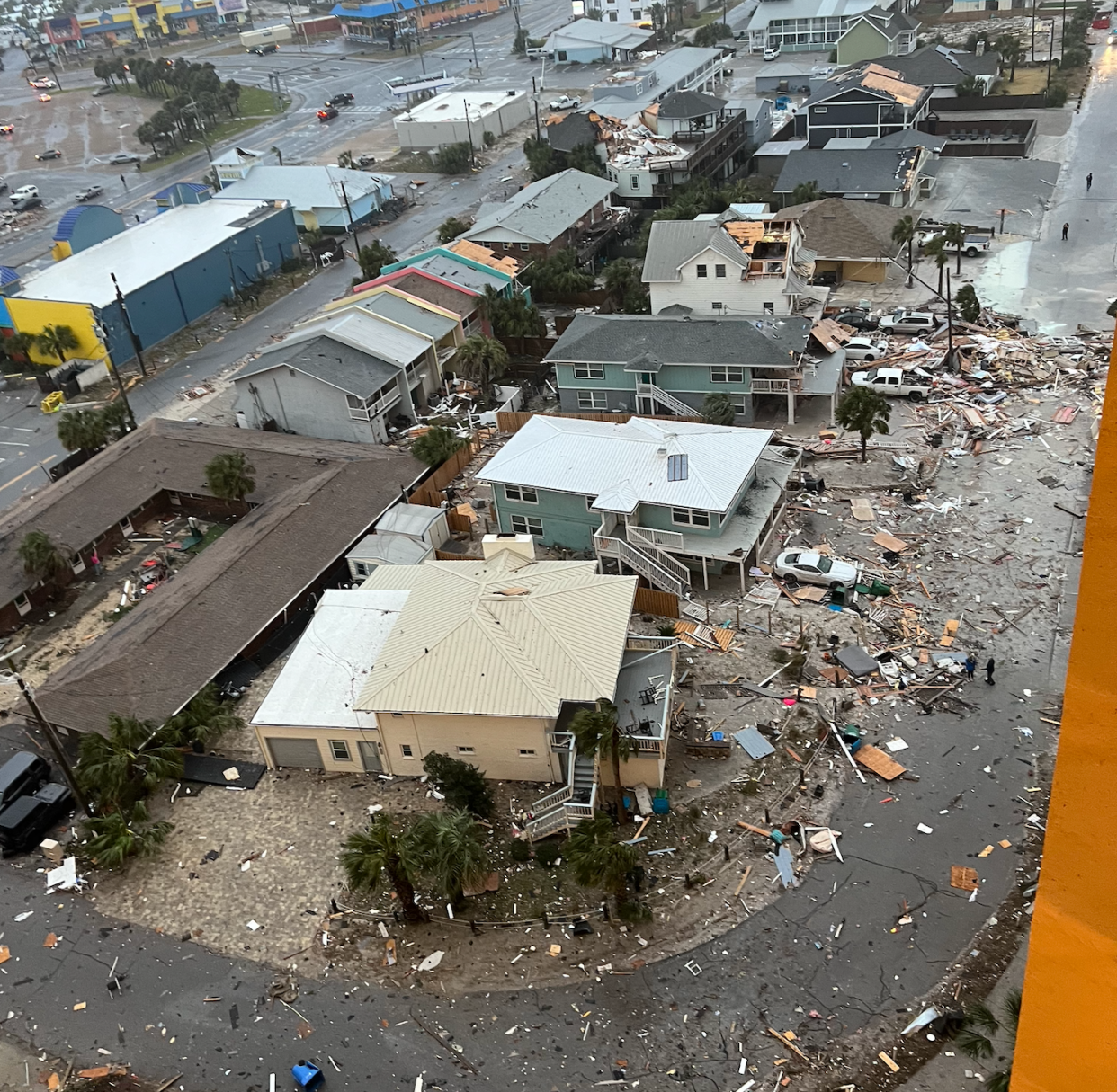
'It's bad': Reported tornado hits Jackson County subdivision, campground resort
A reported tornado in Jackson County damaged and destroyed homes in at least one neighborhood and wrecked an RV campground owned by Tallahassee businessman Erwin Jackson.
Jackson County Administrator Wilanne Daniels said a reported tornado caused "pretty substantial damage" to the Spring Chase neighborhood off Blue Springs Highway and the Florida Caverns RV Resort at Merritt’s Mill Pond on U.S. Highway 90 in Marianna.
Accuweather, meanwhile, posted aerial video showing extensive damage to buildings in Marianna.
She said she had no reports of injuries or death.
Jackson told the Democrat he got a call about the tornado around 5:30-6 a.m. He was driving to the park to assess the damage and deliver coffee and food to the 60-70 campers who were staying at the RV park.
"They tell me a tornado hit kind of the center of the park," he said. We had 77 brand new cabins that we just bought six months ago. Two were completely demolished. There's several RVs that were turned upside down and smashed and blown away. The laundromat was destroyed, a couple of other buildings. It's bad."
He said the manager of the campground was working with Search and Rescue teams look for possible victims.
"If you're in an RV and it turns upside down, you're going to get hurt," he said. "We're hoping for the best."
Spring Chase neighborhood and Arrowhead campground in Marianna, Florida are being called disaster zones. People are missing or buried under rubble. Video comes from a close friend who’s there…. #sayfie#Tornado#panamacity#marianna#floridapic.twitter.com/06tLae0Dj9
— Scott Hagan (@jeffreyscott88) January 9, 2024
He purchased the property just a few days before Hurricane Michael made landfall on Oct. 10, 2018. Jackson went on to rebuild and renovate the damaged campground, paying his last bill on Monday, he said.
"It's unbelievable," he said.
Tornado watch extended east to include Leon and surrounding counties
A tornado watch has been extended east to include the entire Big Bend and counties to the east. A watch means conditions are favorable for twisters to form.
The watch is in effect until 2 p.m. for Bay, Calhoun, Columbia, Dixie, Franklin, Gadsden, Gilchrist, Gulf, Hamilton, Holmes, Jackson, Jefferson, Lafayette, Leon, Liberty, Madison, Suwannee, Taylor, Wakulla, Walton and Washington counties.
The National Weather Service issued the expanded watch amid tornado warnings in Bay, Calhoun and Jackson counties, where reported tornadoes damaged buildings and flipped over campers.
Baseball-sized hail falls in Dothan, Alabama
The National Weather Service shared a photo this morning on social media showing baseball-sized hail in Dothan, Alabama. WTVY in Dothan reported that the hail fell mostly on the city's soutside around the time a tornado warning was issued. The TV station reported that the Dothan Fire Department observed a possible tornado moving across the eastern part of Houston County.
Roughly baseball-sized hail this morning from Dothan, AL. Photo: Faye Godwin. #ALwxpic.twitter.com/WlxC24EdQd
— NWS Tallahassee (@NWSTallahassee) January 9, 2024
Tornado crosses interstate in Marianna as damage reports roll in from Panama City, Lower Grand Lagoon, South Walton
After a blitz of severe thunderstorm and tornado warnings to our west, damage reports are starting to roll in.
A tornado that began in the Panama City area crashed into Lower Grand Lagoon and traveled through Calhoun County amid reports and a photo of golf ball sized hail. Photos and video followed of damaged structures in Panama City and the small beachfront community are beginning to trickle out on social media.
Major damage at Lower Grand Lagoon. We need help #flwxpic.twitter.com/VKmjbjWKV6
— Jay Lesyk (@JayLesykWX) January 9, 2024
At 7:34 a.m., the National Weather Service Tallahassee reported the tornado had just crossed Interstate 10 southeast side of Marianna. A storm chaser later shared a video on X of an overturned semi-trailer on the interstate, which was also blocking the left lane at intersection of Interstate 10 East and mile marker 139.
A different storm chaser's drone video showed an aerial view of the I-10 corridor in Marianna with multiple campers flipped and widespread structural damage.
Our field correspondent @bclemms is on the ground in the Florida panhandle where a tornado hit the I-10 corridor earlier this morning. Numerous campers are flipped with widespread damage in the area #FLwxpic.twitter.com/fLueJVYctN
— WeatherNation (@WeatherNation) January 9, 2024
Two hours earlier forecasters warned Panhandle residents that there was a "confirmed tornado on the ground in southern Walton county north of 30A moving northeast." It traveled north through Freeport and Bonifay. Photos of damaged gas stations and downed power lines followed.
ADDITIONAL STORMS EXPECTED @WCSOFL encourages residents and visitors to AVOID unnecessary travel until the storm completely passes through our area.
We remain under severe thunderstorm warning. Power is out for some areas and debris will be littering to roadway. Use your best… pic.twitter.com/AJGvjv5bqE— Walton Co. Sheriff (@WCSOFL) January 9, 2024
Storm knocks out power to thousands of customers in the Tallahassee area
The storm system moving across the area has already knocked out power to more than 1,000 customers in Tallahassee and at least hundreds more in surrounding counties.
The city of Tallahassee's outage map showed 36 outage orders affecting more than 1,600 customers as of 7:30 a.m. On social media, the city reported “crews have restored service to more than 2,000 customers since 5 a.m., removing fallen limbs and fixing wires. They will continue working as quickly as safely possible until conditions worsen to a point where they need to shelter for safety, too.“
Talquin Electric, which serves portions of Leon, Gadsden, Liberty and Wakulla counties, reported that more than 2,200 customers were without power.
'A dangerous setup': Latest Weather Service forecast on the storm
Andy Haner, meteorologist with the National Weather Service in Tallahassee, said the forecast did not change overnight. The Storm Prediction Center still has the entire North Florida and South Georgia area under an enhanced (3 out of 5) risk for severe weather.
"It's a solid squall line, so everybody's going to be affected by it," Haner said. "What's had our attention the last couple of hours has been separate, big supercell thunderstorms that have crossed Walton and Bay counties. We know there have already been a couple of tornadoes out there. We have reason to believe that one in Walton County was strong."
Haner said a tornado watch in effect for counties to the west of Leon will likely be expanded as the storm progresses.
"This is a dangerous setup," Haner said. "You're not going to want to be out in it when it comes through later on."
Haner said wind gusts of 50-55 mph are possible in Tallahassee before the storm arrives. This morning, a Weather Stem station at the Challenger Learning Center measured a gust over 40 mph. A weather monitoring station in Walton County recorded a 106-mph gust that was likely related to a tornado that moved onshore.
"We've got a lot of trees in Tallahassee — we are a city that was carved out of the forest," he said. "With that kind of wind, you're going to get some trees and at least branches coming down. Basically things are going to be getting progressively worse until the main squall line comes through."
Haner added that reports were coming in about damage in the Panama City area from the suspected tornado.
"It's in the middle of unfolding," he said.
Florida's capital city shuts down – except for DeSantis and the Capitol
By 10 p.m. Monday, the last domino fell after a day of closures that saw Big Bend cities, counties, courts, schools and universities shut down ahead of the storm. At 9.57 p.m. to be exact, the Florida Department of Management Services, which is the business administration arm of Florida government, announced that "with the exception of the Capitol building, state office buildings in Leon County are closed on Tuesday, January 9."
It's a notable exception, which presumably means that the legislative session will open and Gov. Ron DeSantis' State of the State speech can proceed. It is scheduled for 11 a.m., which is around the time forecasters say a dangerous squall line could roar through the city with destructive winds that could down trees, damage homes and lead to power outages.
DeSantis is coming off the presidential campaign trail briefly and flying in from Iowa to deliver the speech. Then he'll need to turn around and head back to the Hawkeye State for a Fox News town hall on women's issues at 6 p.m. ET.
Leon County Schools closed Tuesday
Leon County Schools and school district offices will be closed Tuesday, Jan. 9 because of the weather threat.
"We're going to unfortunately have to shut things down tomorrow for the school district," Superintendent Rocky Hanna announced during a Facebook live on Monday.
The city's three universities are also closed.
As of Monday afternoon, more than two dozen other school districts across Florida had announced closings due to the forecast.
Weather alerts for Tallahassee, Leon County
Track storm on radar

Excessive rainfall forecast
Support local journalism with a subscription to the Tallahassee Democrat.
This article originally appeared on Fort Myers News-Press: Live updates: Latest on severe weather in Tallahassee, Leon County
