Pearl River may crest above flood stage in Jackson. MS power outages rise. Weather updates
The National Weather Service in Jackson is forecasting potential severe weather for Mississippi on Wednesday with the greatest risk in the southern half from along the I-20 corridor and down.
Threats include large hail, damaging winds and possible tornadoes. According to NWS Jackson, the greatest risk will occur during mid-morning in western Mississippi and then in late afternoon in eastern portions.
"On Wednesday, April 10, the entire state will be at risk for severe weather," said MEMA executive director Stephen McCraney in a video posted on the social media platform X on Tuesday. "The National Weather Service is forecasting it to begin around 8 in the morning.
"Tornadoes are likely, especially in South Mississippi. We at MEMA never want to cause panic or anxiety, but we encourage you to remain informed, prepared and vigilant over the next few days as we could experience significant weather."
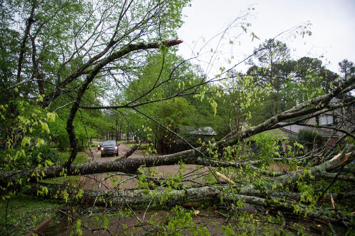
Hinds County Emergency Management reports trees down, homes damaged
The Hinds County Department of Emergency Management reports there have been trees down across the county and five homes damaged as storms have moved through the state Tuesday and Wednesday.
"It's basically trees in homes," said director Joey Perkins. "It's spread around the county.
"All of that occurred last night. It was supposed to be worse today, but as it turns out, it was the other way around. We haven't had any reports of damage from the rains and stuff today."
An advisory of winds up to 50 miles per hour in Jackson and the surrounding areas is currently in effect until 12:30 p.m.
Pearl River at Jackson expected to surpass flood stage
According to the National Weather Service, the Pearl River is expected to surpass flood stage as rain pours over the state.
As of 10 a.m. Monday, the river was at approximately 7 feet on the Jackson gauge. As of 10 a.m. Wednesday, the level had shot up to 21.9 feet with flood stage being 28 feet. By Saturday, the level is forecast to crest at 31.5 feet. However, rain is still falling.
At 31.5 feet, minor flooding will occur. For perspective, during the 2020 flood which impacted more than 600 homes in Hinds, Madison and Rankin counties, the Pearl River crested at 36.67 feet on the Jackson gauge. During the historic Easter Flood of 1973, the river crested at 43.28 feet.
Special Weather Statement issued for Jackson and surrounding areas
A Special Weather Statement has been issued for Jackson and surrounding areas. Winds of 50 miles per hour are expected in the area that ranges from Crystal Springs to Utica, northeast to Flora and east beyond Canton.
The advisory is in effect until 12:30 p.m.
A special weather statement has been issued for Jackson MS, Clinton MS and Pearl MS until 12:30 PM CDT pic.twitter.com/LVBNK5sJIS
— NWS Jackson MS (@NWSJacksonMS) April 10, 2024
Thousands more without power in MS as storms pound state
According to PowerOutageUS, 44,674 customers are without electricity as of 10:30 a.m. Wednesday.
Areas hardest hit are counties surrounding the Jackson area and and those in extreme Southwest Mississippi as severe weather moves through.
Outages in Central Mississippi include:
Hinds County: 6,938
Madison County: 6,209
Rankin County: 957
Warren County: 4,609
Outages in Southwest Mississippi include:
Wilkinson County: 3,794
Amite County: 2,247
Pike County: 5,151
Walthall County: 2,563
Lincoln County: 2,012
Lawrence County: 2,014
Yazoo County neighborhood residents told to evacuate "IMMEDIATELY!"
Residents in a Yazoo County neighborhood were told to evacuate immediately by the Yazoo County Sheriff's Office.
A post on the department's Facebook page reads:
"If you or someone that you know lives in the Eastbrook subdivision on Highway 16 in Yazoo County you need to evacuate IMMEDIATELY!!! The levee is about to break on the lake and the houses will flood. Please get out ASAP!!!"
Heavy rains have hit the area and inches more are expected today throughout the state and river flooding and flash flooding are concerns. Yazoo County falls into an area identified as an "elevated threat" for flooding today with up to an additional 5 inches expected.
National Weather Service updates flash flood warning in MS
The National Weather Service in Jackson has updated a flash flood warning to include Greenwood, Grenada and Winona until 2 p.m. Wednesday.
Flash Flood Warning including Greenwood MS, Grenada MS and Winona MS until 2:00 PM CDT pic.twitter.com/qfOLYMRkyT
— NWS Jackson MS (@NWSJacksonMS) April 10, 2024
Safe rooms and shelters open as severe weather moves across MS
Severe weather with damaging wind, hail and possible tornadoes is moving across Mississippi. Here are places to seek shelter that have been reported to MEMA as of 7:30 a.m. Wednesday.
Adams County Safe Room – Open
323 Liberty Road, Natchez, MS
Copiah County Safe Room (Will open Wednesday, April 10th at 7 a.m.)
1060 Epps Lane, Hazlehurst, MS
Hancock County (Will open Wednesday, April 10th at 10 a.m.)
Leetown Shelter: 28290 Leetown Road, Leetown, MS
Necaise Shelter: 3360 Highway 603, Perkinston, MS
Lamar County Safe Room (Will open Wednesday, April 10th at 8 a.m.)
105 Central Industrial Row, Purvis, MS
Pearl River County – (Will open Wednesday, April 10th at 8 a.m.)
Picayune Community Safe Room: 501 Laurel St, Picayune, MS
Carriere Community Safe Room: 7407 Highway 11, Carriere, MS
Rankin County Safe Room – Open
651 Marquette Road, Brandon, MS
Wilkinson County – Open
Wilkinson County High School Gym – 522 Pon-Pinkneyville, Road, Woodville, MS
Centreville Civic Center – 147 West Main Street, Centreville, MS
Thousands without power as storms move into MS
According to PowerOutageUS.com, 33,156 customers were without electric power as of 7 a.m. Wednesday as storms rolled into the state.
Some of the counties included are:
Hinds: 8,963 outages
Madison: 8,248
Rankin: 795
Warren: 5,297
Flash flood warning issued for Louisiana, South Mississippi Delta
The National Weather Service has issued a flash flood warning for a portion of eastern Louisiana and the South Mississippi Delta until 12 p.m. Wednesday as significant rainfall amounts are expected.
Flash Flood Warning continues for Greenville MS, Bastrop LA and Indianola MS until 12:00 PM CDT pic.twitter.com/oOaQhGdHXA
— NWS Jackson MS (@NWSJacksonMS) April 10, 2024
Tornado watch issued for much of Mississippi
The National Weather Service has issued a tornado watch for much of the state through 1 p.m. Wednesday.
According to the warning, a few tornadoes are likely and hail up to the size of ping pong balls and widespread winds up to 80 miles per hour are also threats.
A tornado watch has been issued for parts of Louisiana and Mississippi until 1 PM CDT pic.twitter.com/8NOF7ocWv8
— NWS Jackson MS (@NWSJacksonMS) April 10, 2024
School closures
Many schools and colleges across the state are closed or have gone virtual. Madison County Schools and Canton Public Schools are among the closures.
This story will update as information becomes available.
Do you have a story idea? Contact Brian Broom at 601-961-7225 or bbroom@gannett.com.
This article originally appeared on Mississippi Clarion Ledger: MS weather could be severe Wednesday
