Lightning, hail possible as storms head for Dallas-Fort Worth; 2 inches of rain expected
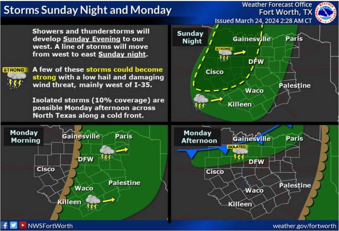
As southerly winds blow warm and moist air into the Dallas-Fort Worth region later today and into the evening hours, expect up to an inch of rain overnight in some parts and up to 2 inches in counties northeast of the Metroplex, according to the National Weather Service Fort Worth office.
The high atmospheric disturbance will race east, where a dry line near Wichita Falls and Abilene will form, spawning a string of storms packing possible lightning and even a low threat of hail.
“Expect a line of storms to move from west to east overnight, moving across the I-35 corridor after midnight and moving into East Texas near sunrise,” Fort Worth lead meteorologist David Bonnette wrote on the NWS website. “There is a window for strong to severe storms this evening as storms push into western North and Central Texas.”
⚡ More trending stories:
→ There’s no ‘better place’ to see April 8 total solar eclipse than in this tiny Texas town.
→ How a six-pack of beer, $100 got rescuers to pull pig out of thorns.
→When do tornadoes occur the most in Dallas-Fort Worth?
These new storms come in the heels of the weather events North Texas saw the past couple of days. Just last week, parts of the region was pummeled by baseball-size hail and even a tornado.
By midday Sunday, a high atmospheric disturbance in southeast Colorado will nudge a new cold front into our region as stronger-than-normal southerly winds blow our way. This will form a dry line — the boundary between moist and dry air masses — and as it moves eastward may spawn the storms in the forecast for late Sunday and into Monday. Severe thunderstorms packing possible tornadoes often develop along a dry line or in the moist air just to the east of it, especially as it begins to move.
Rain will be continuous for hours overnight Sunday until drier air moves into the area early Monday, according to the NWS.
“Most can expect to receive between 1/2” and 1” of rain tonight and early tomorrow morning. Locations northeast of the Metroplex could receive up to 2” of rain,” Bonnette wrote..
A cold front arriving Monday will keep things cooler until midweek, when another storm system moves into North Texas.
“A warming trend is expected to occur through late this upcoming week, with temperatures returning to the 70s by Friday,” Bonnette wrote.
After the early Monday storms, a cold front will push through the region bringing cooler temperatures for midweek. There is a low chance for a few rain showers on Wednesday. Temperatures will warm-up into the end of the week with 70s expected by Thursday and Friday. #dfwwx #ctxwx pic.twitter.com/CaC2D7k94D
— NWS Fort Worth (@NWSFortWorth) March 24, 2024
Sunday wind advisories continue
Southerly winds are increasing throughout the morning and into the afternoon hours. The weather service issued a wind advisory late Saturday for Sunday. Dropping air pressure on the lee side of the Rockies drew the south winds, accelerating speed as it blew through Central and North Texas.
“South winds will increase in response to the rapid pressure drop to our northwest. This will be especially true by mid-morning when the boundary layer fully-mixes,” according to the NWS forecast Sunday morning.
Gusts of up to 40 mph are expected later in the afternoon and winds of 20-30 mph possible along and west of I-35.
“Most of Central and East Texas will still experience gusty winds today, but not quite to our advisory level. The strongest wind speeds will take place from about noon to 5PM. A few locations across Western North Texas could receive gusts up to 50 mph during this time,” the forecast states.
