Tropical Storm Sean forms in Atlantic, but nontropical Gulf system to bring rain, wind to Florida
Tropical Storm Sean formed Wednesday morning in the Atlantic while the National Hurricane Center began tracking a new tropical wave that could form into the next tropical depression or storm. Meanwhile, the Gulf of Mexico system that is no longer a tropical threat will bring its high winds and rain across Florida today and into Thursday.
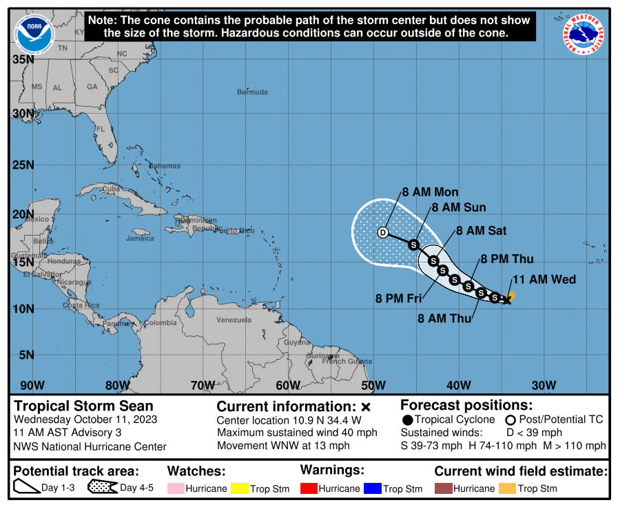
As of 11 a.m., the NHC said the center of Tropical Storm Sean was located about 780 miles west-southwest of the Cape Verde Islands moving west-northwest at 13 mph with maximum sustained winds of 40 mph. Tropical-storm-force winds extend out up to 90 miles.
“A west-northwestward to northwestward motion is forecast during the next few days,” forecasters said. “Little net change in strength is forecast during the next 72 hours.”
The system formed as a tropical depression late Tuesday and grew in strength to take the 18th letter of the 2023 Atlantic hurricane season’s initial 21-letter list of storm names, although an unnamed subtropical storm in January makes Sean the 19th official system of the year.
The NHC also began tracking a tropical wave that came off the coast of Africa into the far eastern tropical Atlantic that is producing a large
area of disorganized showers and thunderstorms.
“This activity is showing some signs of organization this morning, and environmental conditions appear conducive for some additional development of this system over the next several days while the wave moves westward across the eastern and central tropical Atlantic,” forecasters said.
The NHC gives it a 20% chance to develop in the next two days and 30% chance in the next seven.
If it develops enough it could become Tropical Storm Tammy with only the names Vince and Whitney left on this year’s initial list. If a 22nd named storm occurs, the NHC will delve into a supplemental name list created by the World Meteorological Organization starting with Adria.
The NHC ceased projections that a Gulf of Mexico system would develop, but it is still expected to produce gale-force winds as it moves north toward the Gulf Coast. Part of the expansive low pressure system includes it sucking up a warm front across Florida’s peninsula on Wednesday that will dump 1-3 inches of rain across parts of the state with some areas seeing up to 4 inches, and also a threat of thunderstorms and high winds.
The National Weather Service in Tampa Bay said there is a chance for isolated tornadoes and waterspouts and the higher winds of 60-70 mph could be felt along the Gulf Coast.
Rain will move across Central Florida beginning Wednesday afternoon.
