Storm damage reports come in from across North Texas after tornado watch expires
Damage assessments were underway Thursday night after powerful winds that roared through Dallas-Fort Worth led to severe thunderstorm and tornado warnings in the Metroplex and surrounding counties.
More than 270,000 people were without power in the region Thursday night, according to Oncor.
In Weatherford, police said officials were assessing what they initially believed to be tornado damage. The National Weather Service said Friday that it believes the damage was caused by straight line winds.
Weatherford police encouraged residents to watch for debris, downed power lines, and damaged gas lines or electrical systems. Residents were also encouraged to stay off the roads due to debris.
No injuries have been reported, police said.
Officials have not released an estimate or number of damaged buildings but advised residents to “be careful when entering any damaged structure. Beware of hazards from exposed nails or broken glass.”
“At this point we cannot provide you with full details because members of our team are continuing to assess the situation and perform damage assessment,” a Weatherford Emergency Management statement Thursday night said. “Our primary goals are to insure the safety of everyone, to continue serving the public and to provide the most accurate information we can as quickly as possible. Please avoid dialing 9-1-1 unless it is an emergency due to high call volumes at this time. To report property damage, please visit https://damage.tdem.texas.gov or use the QR code. This tool is designed to deploy early in a disaster impact area to gather Rapid Damage Assessment information revealing the scope and size of an event for public safety personnel.”
In a second update about 8:15 p.m., city officials said that about 10,000 households and businesses were without power. “This is over half of our electric customers. Due to the extent of the damage our main priority is getting power back to critical care units, such as nursing homes and medical facilities. We will continue to provide updates as quickly as possible, but we do not have an estimation on when power will be restored to residents and businesses without power. We understand the frustrations of being without power and we are working as quickly as possible.”
Weatherford ISD said that because of power outages, debris on roads and minor damage to some campuses, all of the district’s schools and offices will be closed Friday, March 3.
A severe thunderstorm warning was in effect for Parker County until 6 p.m. Just before 5, a severe thunderstorm was located over Cool and Mineral Wells, moving east with 70 mph wind gusts and quarter-size hail.
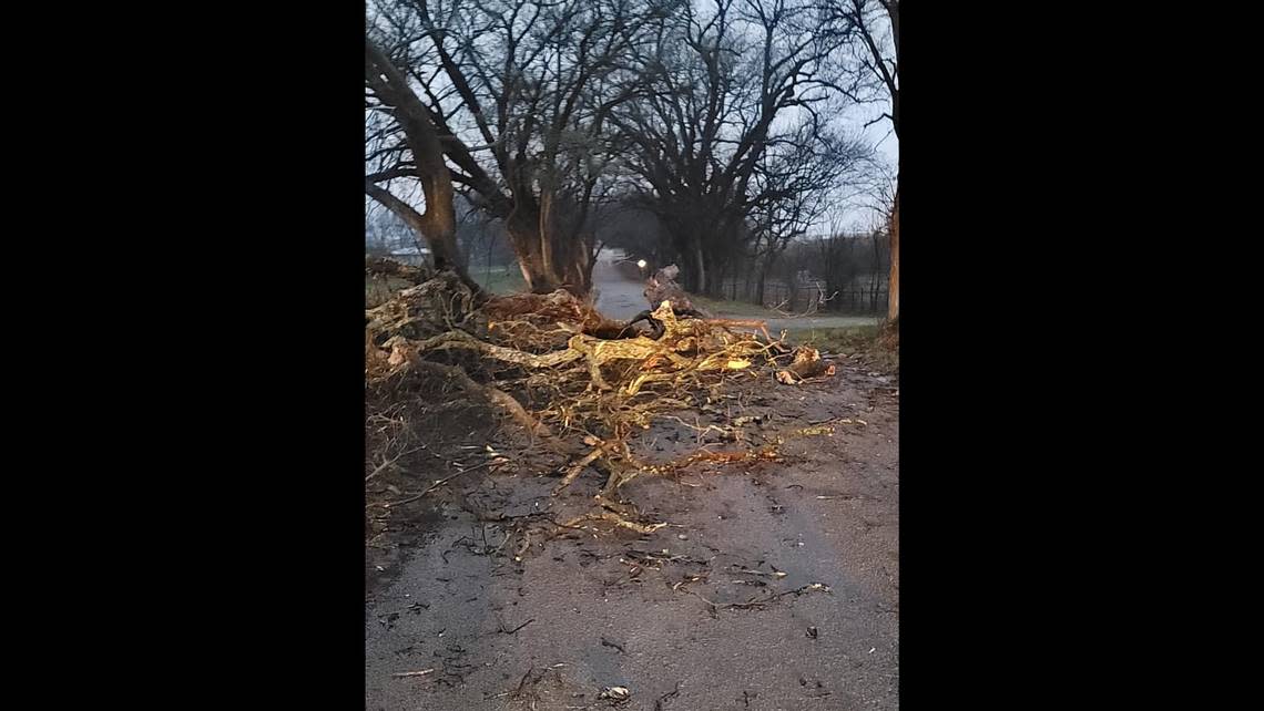
In Millsap, officials reported a fire station lost part of its roof to wind damage.
“Prayers for the safety of Parker County tonight,” Parker County Judge Pat Deen wrote on Facebook. “Working with our EOC along with cities and legislators on the impact storms have/had. Crews are working to get power restored.”
Deen posted photos showing large trees knocked down by the storm.
According to the Weatherford Democrat, Mineral Wells ISD Superintendent John Kuhn reported a portable classroom building also sustained damage.
Fort Worth-area damage reports
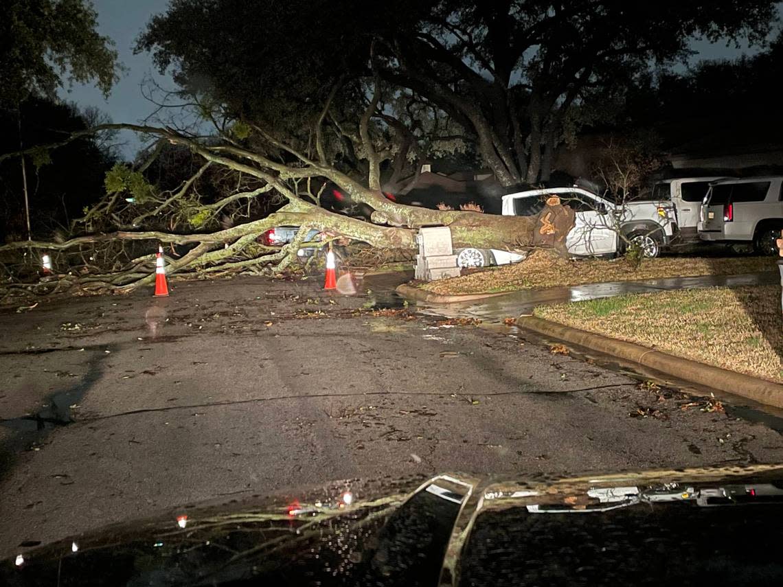
Around 62,000 people in Fort Worth were without power and vehicles were overturned, but no loss of life has been reported so far, the Fort Worth Fire Department said Thursday night.
MedStar confirmed an 18-wheeler was involved in a rollover, as were two other vehicles. Four people were taken to hospitals because of storm-related crashes, of which there were 21 reported.
With wind speeds surpassing 70 mph, warning sirens in Fort Worth were sounded around 5:40 p.m. Thursday, prompting people to rush outdoor furniture inside and others to stand and gaze up at dark, fast-moving clouds and the signs of impending rain.
No tornado warning was issued in Tarrant County, but residents shared a video with the Star-Telegram that appears to show a funnel cloud near Northlake and the Texas Motor Speedway.
Police and fire department personnel were responding Thursday evening to several calls about downed power lines, likely due to high wind speeds.
The fire department said just after 7 p.m. that firefighters were responding to two working fires in the wake of the storm, but it wouldn’t be clear until after an investigation if the severe weather caused them.
An apartment complex in Hurst — Hunter Chase — had roof damage and broken windows, according to a report made to the National Weather Service. About two dozen residents of the apartments were displaced and were being assisted by the Red Cross, KDFW-TV reported.
In north Fort Worth, the Fort Worth Office of Emergency Management had received reports of damage to roofs and fences of homes, and throughout the city, lawn furniture, trampolines and other debris were strewn throughout streets and across yards.
JD’s Hamburgers on Camp Bowie West Boulevard in far west Fort Worth will be closed Friday after losing “a good portion” of its roof and roof sign, owner Gigi Howell posted on Facebook.
In White Settlement, Police Chief Christopher Cook tweeted that there was, “Definitely some wind damage in our city with tree uprooted in 100 block of Saddle and leaning into utility pole lines, fences down in some neighborhoods, and major roof damage to business in 1500 block of S. Cherry.”
Definitely some wind damage in our city with tree uprooted in 100 block of Saddle and leaning into utility pole lines, fences down in some neighborhoods, and major roof damage to business in 1500 block of S. Cherry. pic.twitter.com/lbdeHK6Wpt
— Christopher Cook (@cooktx) March 3, 2023
In North Richland Hills, emergency dispatchers answered over 400 calls in three hours, police said in a news release.
Officials noted widespread damage including large trees uprooted and power outages across North Richland Hills.
Residents were asked to call 817-281-1000 about downed lines or debris blocking major roadways. Debris blocking minor roadways can be reported online at nrhtx.com/reportconcern
In Tarrant County, more than 95,000 customers were without electricity about 7 p.m., according to Oncor’s website. More than 110,000 were without power in Dallas County.
A severe thunderstorm warning was in effect for Tarrant County until around 7 p.m. It was expected to be a destructive storm with wind gusts over 80 mph, the National Weather Service warned.
Residents in Tarrant County, including Fort Worth and Arlington were told to expect “wind speeds as strong as a weak tornado,” and stay away from windows, the weather service said.
If your phones alerted and you hear sirens, that is for wind speeds as strong as a weak tornado. So treat it like one! Get inside, away from windows! #dfwwx https://t.co/ShB2z2kL4k
— NWS Fort Worth (@NWSFortWorth) March 2, 2023
Dallas, Collin and Denton counties
A similar warning was in effect for Dallas and Collin counties until 7:15 p.m. and a tornado warning was in effect for southern Dallas County until 7.
Residents were warned to expect considerable damage to roofs, windows and vehicles, as well as extensive tree damage and power outages.
Between 6 and 8:30 p.m., Dallas Fire-Rescue responded to 40 motor vehicle accidents, two high-water incidents, four automatic fire alarms, and 76 calls about power lines and transformers.
According to the weather service, a semi truck blew over and blocked the westbound lanes of Interstate 20 in southeast Dallas about 6:45 p.m.
In Collin County, wind damage was reported to businesses at Preston Road and West Park Boulevard, the weather service said.
Storms warnings also were in place for Denton, Somervell, Erath and Hood counties around the same time.
In Denton County, a partial building collapse was reported at a shopping center at West El Dorado Parkway and South Park Drive in Little Elm. WFAA-TV reported that part of La Azteca Meat Market collapsed onto cars in front of the store.
La Azteca front facade collapses onto parked vehicles in Little Elm after strong wind. No injuries to report. @wfaa @wfaaweather pic.twitter.com/KxdfCP6Iys
— Jobin Panicker (@jobinpnews) March 3, 2023
North Texans began seeing scattered severe storms Thursday afternoon, which was followed by a greater risk of more widespread severe weather in the evening, according to the National Weather Service.
A tornado watch was in effect for much of North Texas but was allowed to expire early for Tarrant and Dallas counties and counties farther west.
Storm Reports
This map contains continuously updated storm reports and damage from the National Weather Service for the past 48 hours. Reports include tornado, wind storm and hail storm reports. The map also includes tornado reports for the past week and recent rainfall accumulations. Sources: National Oceanic and Atmospheric Administration (NOAA), Esri.
The first tornado warning of the day was issued for the Breckenridge and Caddo area in Stephens County until 4:30 p.m., when radar indicated possible rotation. Damage to trees and outbuildings was reported near the city of Necessity.
Another tornado warning was in effect until 5 p.m. for Hopkins County, Franklin County, Titus County and Red River County in northeastern Texas. At 4:33, weather spotters confirmed a tornado was located near Purley, about 11 miles north of Winnsboro, moving northeast at 45 mph. In Pickton, in Hopkins County, roof damage was reported to a house along Texas Highway 11 at FM 269. Downed trees and power lines also were reported.
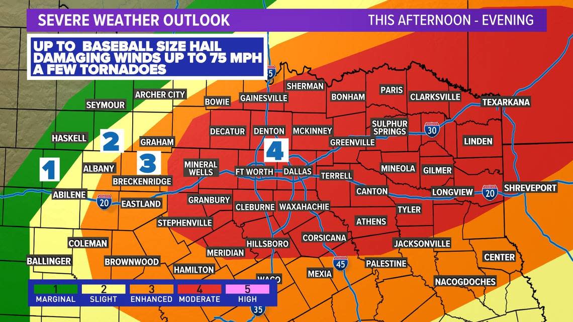
Steve Fano, a spokesperson for the National Weather Service in Fort Worth, said the biggest threat from severe weather would start late in the day when a line of storms packing large hail, damaging winds and possible tornadoes moved through the region.
Fano said the window for those more intense storms in the Fort Worth area was from 5 to 8 p.m., after which the storms moved farther east.
A Tornado Watch is in effect for the yellow shaded area until 10 PM this evening. Damaging winds up to 75 mph, large hail up to 3 inches, and a few tornadoes will all be possible as we head into this evening. #dfwwx #ctxwx #txwx pic.twitter.com/px3083HEKF
— NWS Fort Worth (@NWSFortWorth) March 2, 2023
The weather service had expanded the area that was at a Level 4 or moderate risk level to include most of North Texas. A Level 4 storm includes threats of baseball-size hail, tornadoes and wind gusts up to 75 mph, according to WFAA meteorologists.
No parts of the region were at a Level 5, which is the highest and rarest risk level.
Some isolated storms began popping up Thursday afternoon. Severe thunderstorm warnings were in effect for Wise, Cooke and Denton counties until 3:45 p.m., with warnings of large hail.
At 2:14 p.m., a severe thunderstorm was located 7 miles southwest of Paradise, or 8 miles south of Bridgeport, moving northeast at 45 mph. Radar indicated the storm had hail up to the size of ping pong balls and 60 mph wind gusts.
At 2:12, a severe thunderstorm was located near Sanger, moving northeast at 45 mph with radar-indicated 60 mph wind gusts and half-dollar-size hail.
Very thick hail fog in extreme NW Denton county. 15 miles west if Sanger. @NWSFortWorth @TxStormChasers pic.twitter.com/1ycrcN69Pv
— Chad Casey (@WxFanaticCC) March 2, 2023
Palo Pinto County was under a warning until 5:30 p.m. A severe thunderstorm was located near Possum Kingdom State Park, about 20 miles south of Graham, moving east at 45 mph.
Gov. Greg Abbott announced Wednesday that he directed the Texas Division of Emergency Management to prepare state emergency response resources.
“The State of Texas is fully prepared to assist local officials and emergency response personnel on the ground to keep our communities safe,” Abbott said in a statement. “We remain on standby to provide any additional resources that may be necessary over the course of this storm.”
Weather watches and warnings
A live data feed from the National Weather Service containing official weather warnings, watches, and advisory statements. Tap warning areas for more details. Sources: NOAA, National Weather Service, NOAA GeoPlatform and Esri.
Flight cancellations and delays
Stormy weather means flights were canceled and delayed out of North Texas airports.
Due to Thursday’s weather conditions and thunderstorms, there was a Traffic Management Program, or ground stop, in effect for some flights arriving to DFW Airport, according to the Federal Aviation Administration’s Air Traffic Control System Command Center.
Nearly 160 flights leaving Dallas-Fort Worth International Airport had been canceled Thursday as of 5:30 p.m., about 15% of the day’s flight schedule. Meanwhile, more than 190 arrivals to DFW had been canceled, according to Flight Aware.
Nearly 50 departing flights to Dallas Love Field Airport had been canceled, about 12% of Thursday’s flight schedule. More than 50 arrivals were also canceled.
Across the country were more than 12,700 delays Thursday and more than 1,550 cancellations nationwide.
Most major airlines are waiving change fees for canceled or delayed flights. Find American Airlines travel notice page here, United Airlines weather advisory page here, and Southwest Airlines travel alerts here.
3-Day Storm Outlook
This map shows the 3-day weather outlook for storms by the National Weather Service's Storm Prediction Center. Sources: National Weather Service, Esri.
After-school activities canceled
Area school districts canceled after-school activities Thursday. Districts including Fort Worth, Arlington and Mansfield ISDs canceled all after-school activities for the day. See the full list here.
The Fort Worth school district is closely monitoring weather conditions and will maintain communication with the National Weather Service and local agencies, the district said in a statement. Any further updates will be shared via the Fort Worth ISD Mobile App, Facebook, Instagram, Twitter, the district’s website, and local news.
Remembering Fort Worth’s devastating 2000 tornado
The last time a major tornado hit Fort Worth was nearly 23 years ago this month, when an F2 twister destroyed parts of West Seventh Street and battered downtown. It was the first deadly tornado to hit the city in modern times.
Here are photos from that destructive storm, which also spawned a tornado in Arlington.
Weekend and next week forecast
Windy conditions will continue on Friday, especially during the morning hours with gusts between 35 and 45 mph possible, according to the weather service.
Friday will be sunny, with a high near 65 and a low around 45.
Saturday and Sunday should have clear skies with highs around 75 and lows in the 50s.
Thunderstorm chances will return by the middle of next week with the arrival of a strong cold front and upper level disturbance.
Current Temperatures
Current temperatures and weather data from NOAA weather stations updated hourly. Tap on the map for current weather conditions, including humidity, wind speed. and direction. Data provided by NOAA and Esri.
Star-Telegram staff writer Jenny Rudolph contributed to this report.
