Las Vegas records month's worth of rain in less than 2 hours as storms drench Southwest


After potent thunderstorms rolled through Las Vegas on Thursday night, portions of the iconic Las Vegas Strip were left under water as floodwaters poured into area casinos. AccuWeather forecasters say the same pattern that allowed storms with torrential rainfall and strong winds to buffet Las Vegas will persist across much of the Southwest.
Some visitors to Sin City were left stranded or scrambling to seek shelter on Thursday night as severe thunderstorms rolled through the area. The National Weather Service office in Las Vegas reported wind gusts of up to 70 mph with the storms that roared to life on Thursday night.
The sky opened up across the Las Vegas metro on Thursday night, and heavy rainfall turned streets and sidewalks along the iconic Las Vegas Strip into raging rivers as flash flooding developed.
Water levels ranged from considerable ponding on popular walkways to several inches deep within the worst flooding on roads. Eyewitness video from the event showed vehicles driving through flooded roadways, sending waves of water rippling.
The storm has arrived at the weather forecast office! Very strong winds over 60 mph are moving through the valley now and very heavy rain! #VegasWeather pic.twitter.com/naAdZsmuOf
— NWS Las Vegas (@NWSVegas) July 29, 2022
Water also flowed into a handful of popular casinos. Roof leaks allowed rain to fall in Caesars Palace while water gushed from behind video screens in Circa Resort & Casino. Elsewhere, a waterfall poured from the roof of Planet Hollywood.
Across the city, the Las Vegas Fire & Rescue responded to a total of 330 calls for service on Thursday night, many related to the storm. At least seven people were rescued from swift water, Las Vegas Fire & Rescue confirmed on Twitter.
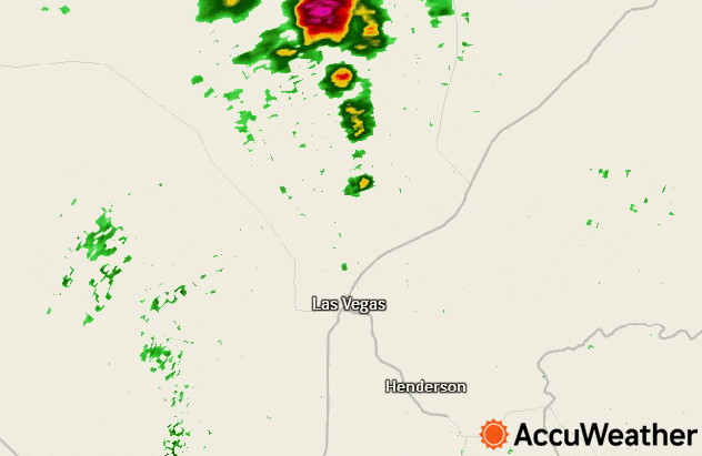
Harry Reid International Airport, Las Vegas' main air hub and the official climate reporting station for the city, is located about 5 miles south of downtown Las Vegas. The airport picked up 0.32 of an inch of rain from Thursday night's storms in just under two hours. On average, the airport typically records about a third of an inch of rainfall throughout the entirety of July.
 |
Radar shows storms training over the city of Las Vegas, Nevada from 8 p.m. to 10 p.m. on the evening of July 28, 2022. |
While the airport recorded about its monthly rainfall in just two hours, parts of downtown Las Vegas picked up double or even triple that amount of rain in the same length of time.
Rainfall reports from across the greater Las Vegas metro generally ranged from 0.50-0.75 of an inch from Thursday's storms.
While these amounts may seem very small to residents in the eastern United States dealing with devastating flooding, almost any amount of rain in the West's desert climate can be enough to trigger significant impacts.
"It doesn't take much rain to cause flash flooding problems in this part of the country, especially when the rain comes down fast and furious," AccuWeather Meteorologist Reneé Duff said. "In Las Vegas, all it took was 0.29 of an inch of rain falling in an hour's time to cause vehicles to become stranded in the streets on Thursday night."
 |
Nevada was not the only state that saw impacts from flooding. Extreme Meteorologist Reed Timmer was in Rimrock, Arizona, on Thursday as a powerful flood unfolded over what was previously dry land. Timmer, who said about 2 inches of rain had fallen at the time of his recording, captured footage that showed the power of the fast-moving and muddy floodwaters carrying debris over a roadway. The roar of the approaching water could be heard before it was seen on video. Rimrock is about 83 miles to the north of Phoenix.
Additional storms were seen in the Las Vegas area yet again Friday evening, prompting the issuance of a Severe Thunderstorm Warning for most of the metro area. Fortunately, however, the city was spared from the heavy rain. Only 0.03 of an inch was recorded at the airport, and amounts generally remained around a quarter inch or less throughout the city. Strong and gusty winds did arrive again though, with a wind gust to 52 mph at the airport.
 |
Radar shows showers and thunderstorms located in southern Nevada and northwest Arizona at around 7 p.m. local time on July 29, 2022. |
AccuWeather forecasters say the overall pattern on Monday will continue to favor showers and storms in the area. It is no guarantee that Vegas receives heavy rain, and some spots may get missed and stay entirely dry, but it is a roll of the dice that can lead to localized flooding in some areas.
"The weather pattern over the next day will continue to be one that is conducive for producing showers and thunderstorms that can dump heavy rainfall in a short amount of time across the Southwestern states," Duff cautioned.
The pattern in place across the Southwest is what is known as the North American monsoon. The monsoon generally marks a time of much-needed rain for the parched region. While flooding has proven disruptive in Las Vegas, any rainfall will help alleviate the historically low water levels in nearby Lake Mead. However, looking forward into the week, a change to drier weather may be on the horizon in Sin City.
 |
"Heading into the first week of August, there will likely be a decrease in thunderstorm activity across the region as drier air works its way into the atmosphere," Duff explained. "Downpours are still likely to be scattered about in the high terrain, but aerial coverage should decrease."
Want next-level safety, ad-free? Unlock advanced, hyperlocal severe weather alerts when you subscribe to Premium+ on the AccuWeather app. AccuWeather Alerts™ are prompted by our expert meteorologists who monitor and analyze dangerous weather risks 24/7 to keep you and your family safer.
