Large hail, damaging winds possible as Kansas City area preps for a stormy week ahead
Dry and calm weather is expected Monday in the Kansas City area, but showers and thunderstorms return mid-week, bringing the chance of severe weather, the National Weather Service said.
Sunny skies will help temperatures climb into the low 70s on Monday. The average temperature in Kansas City is 69 degrees this time of year.
After a sunny Tuesday, strong to severe thunderstorms will be possible in the afternoon and evening, according to the weather service.
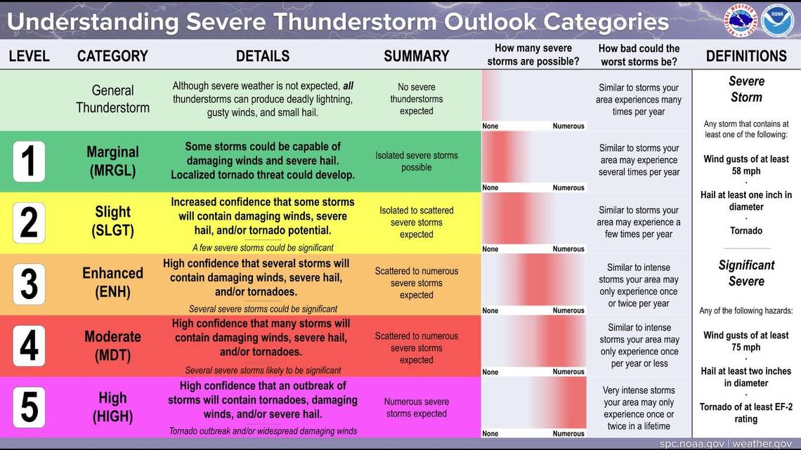
The weather service’s Storm Prediction Center has placed the Kansas City area, eastern Nebraska, western Iowa and southwestern Minnesota at a slight risk of severe thunderstorms.
The main severe threats in Kansas City from the storms are large hail and damaging winds, the weather service said. Additional rainfall may aggravate ongoing river flooding or cause flash flooding. Eastern Nebraska, western Iowa and southwestern Minnesota are at a greater risk of seeing tornadoes.
Temperatures on Tuesday are expected to be in the low 80s.
Showers, thunderstorms continue in Kansas City area
Wet weather will continue on Wednesday and Thursday, with showers and thunderstorms expected. Temperatures are expected to be in the upper 70s.
Cooler and drier air is expected Friday, leading to quieter weather. Temperatures will likely be near 70 degrees.
Another round of heavy rainfall may return to the Kansas City area Saturday into Sunday, aggravating ongoing river flooding. Because of the recent rains, flash flooding would also be a concern this weekend if additional rounds of heavy rains occur, the weather service said.
