At least five tornadoes confirmed across Kentucky. Storm cleanup underway
Live updates for this story has concluded. For the latest information about the April 2 storms, visit kentucky.com.
At least five tornadoes touched down in Kentucky Tuesday during a series of severe storms.
The National Weather Service has confirmed three EF-1 tornadoes in Anderson, Jessamine and Nelson counties. At 5:48 p.m. the NWS said a confirmed tornado was located near Coldstream, Kentucky, in Jefferson County moving east at 45 mph.
WKYT, the Herald-Leader’s reporting partner, reported the NWS has confirmed an EF-1 tornado in Boyd County.
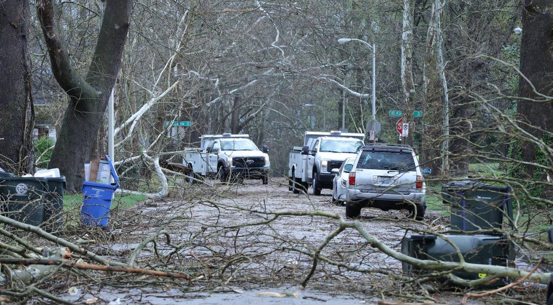
More damage assessment surveys are planned for Wednesday. Gov. Andy Beshear said damage has been reported in Anderson, Bath, Ballard, Bourbon, Boyd, Carter, Clark, Elliott, Fayette, Greenup, Kenton, Jefferson, Jessamine, Mercer, Montgomery, Nelson, Powell, Union and Woodford counties.
Approximately 5,300 people are without power in Fayette County as of 6:20 a.m. Wednesday, according to poweroutage.us, a website that tracks power outages nationwide. That figure was over 10,000 in the immediate aftermath of the storm.
Large power outages were also reported in Boyd, Carter, Jefferson and Lawrence counties.
Power outage maps from Kentucky Utilities Co. and Blue Grass Energy showed a number of people in Central Kentucky without power but indicated some getting service back since 5 p.m. Tuesday.
Beshear has declared a state of emergency across the state. Here is what happened on Tuesday during the weather outbreak.
Reporters Monica Kast, Bill Estep and Valarie Honeycutt Spears contributed to this article.
Tornado watches and warnings are already in effect as severe weather moves across Kentucky today. These storms could bring damaging winds, hail and tornadoes. Please be weather-aware and tuned to local weather reports.
Be safe, everyone!— Governor Andy Beshear (@GovAndyBeshear) April 2, 2024
More confirmed tornadoes
9:15 p.m. — WKYT, the Herald-Leader’s reporting partner, says the National Weather Service has confirmed an EF-1 tornado in Boyd county in addition to Nelson and Anderson counties.
Jessamine Emergency Management officials said the National Weather Service had just completed a damage assessment in Nicholasville and was classifying a storm there as an EF-1 Tornado with wind speeds of 110mph.
Severe weather still concern for Lexington area
7 p.m. — The National Weather Service forecast for Lexington at 6:30 p.m. Tuesday said severe storms remain likely into the evening. Damaging winds, large hail and tornadoes are all possible.
Localized flash flooding is also possible in areas impacted by repeated heavy rainfall, NWS said.
Rain on Wednesday could mix with or change to snow Wednesday night into Thursday morning. A light accumulation of snow cannot be ruled out, but significant impacts from snow are unlikely.
Suspected tornado near Louisville
6:25 p.m. — WDRB in Louisville reported a suspected tornado was on the ground in Oldham County Tuesday evening.
“The suspected tornado started in eastern Jeffersonville and moved across the Ohio River into the Prospect and Goshen areas,” WDRB said, noting a tornado had hit Prospect.
Third tornado reported in Kentucky
6 p.m. — At 5:48 p.m., the NWS in Louisville said a confirmed tornado was located near Coldstream, Kentucky, in Jefferson County moving east at 45 mph.
Two EF-1 tornadoes were reported earlier Tuesday in Anderson and Nelson counties.
Fire in Mount Vernon
4:15 p.m. — Andrew Pensol, an official with Rockcastle County Emergency Management, said the US Weather Service at Jackson is investigating whether Tuesday’s storms led to a fire in downtown Mount Vernon.
An abandoned building on Main Street caught fire and an adjoining occupied building was damaged, Pensol said.
No injuries were reported.

Multiple cities, counties submit disaster declarations from storm damage
4:10 p.m. — Multiple cities and counties in Kentucky have submitted disaster declarations to Gov. Andy Beshear’s office as a result of damage from Tuesday’s storm.
Boyd and Greenup counties and cities of Ashland and Catlettsburg have submitted written disaster declarations, according to Beshear. Verbal disaster declarations have been submitted by Bourbon, Clark, Elliott, Jessamine and Kenton counties and the city of Villa Hill.
There are damage reports out of Anderson, Bath, Ballard, Bourbon, Boyd, Carter, Clark, Elliott, Fayette, Greenup, Kenton, Jefferson, Jessamine, Mercer, Montgomery, Nelson, Powell, Union and Woodford counties, according to Beshear.
The NWS has already confirmed two EF-1 tornadoes touched down in Anderson and Nelson counties with damage surveys ongoing.
There are 31,650 power outages reported in Kentucky, according to Beshear. As of 4:04 p.m., at least 1,000 outages are reported in Boyd, Calloway, Carter, Greenup, Fayette and Marshall counties, according to poweroutages.us, a website that tracks power outages nationwide.
Lexington back under tornado watch
4 p.m. — The NWS has issued a tornado watch for Fayette County until at least 10 p.m.
The watch also includes many other counties in Central and Western Kentucky along with areas of southern Indiana and Ohio, according to the NWS. A few tornadoes, wind gusts up to 75 miles per hour and two-inch sized hail are likely while the watch is in effect.
A tornado watch has been issued for parts of Indiana, Kentucky and Ohio until 10 PM EDT pic.twitter.com/6LQurBgia6
— NWS Louisville (@NWSLouisville) April 2, 2024
In the NWS’ forecast discussion posted at 4:07 p.m., meteorologists said the threat of severe weather is ramping up as storms try to become more organized before the incoming cold front. Any storm ahead of the cold front will have the ability to turn severe.
The threat will likely diminish earlier for counties in Northern and Western Kentucky, according to the NWS.
Second tornado confirmed in Kentucky, more damage surveys planned
3:15 p.m. – The NWS confirmed that a tornado touched down in Anderson County, marking at least the second tornado during Tuesday morning’s storm.
The NWS said the tornado’s wind speed peaked at 90 miles per hour, categorizing it as an EF-1 tornado.
Anderson County Judge-Executive Orbrey Gritton said several barns lost roofs in the county but that appeared to the worst of the damage.
Anderson County officials were busy Tuesday afternoon clearing debris to make sure those roads were passable. Gritton said multiple trees were down and blocking roads.
“We have missed the brunt of it so far,” Gritton said around 3 p.m.
The first tornado happened in Nelson County and reached wind speeds of 95 miles per hour, according to the NWS.
The NWS has received damage reports across central Kentucky, including in Fayette, Bourbon, Clark, Jessamine, Mercer and Woodford counties. Storm surveys are scheduled for the area.
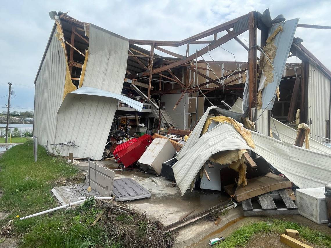
More than a dozen businesses damaged in Jessamine County
2:30 p.m. — Between 15 to 20 businesses in an industrial area off of U.S. 27 in northern Jessamine County were damaged during Tuesday morning’s storm, said Jessamine County Judge-Executive David West.
“We are just very thankful that no one was taken to the hospital and there was no injuries” said West, who visited the area earlier on Tuesday. One worker told him he was closing a garage door when the storm ripped the door out of his hand.
The straight line winds or possible tornado ripped apart various buildings in the area behind the Boot Store on U.S. 27, West said. A nearby mobile home park was thankfully untouched, he said.
In addition to the businesses that were damaged, several cars and vehicles were flipped by the violent storm, West said.
Jessamine County has also been hit by power outages. The Walmart in Nicholasville was without power as of 2 p.m. Tuesday. According to poweroutage.us, approximately 1,300 customers were without power as of 2:30 p.m.
“The power crews are working hard to restore power,” West said.
Beshear declares state of emergency
2 p.m. – Gov. Andy Beshear has declared a state of emergency for Kentucky after severe storms damaged areas and left thousands without power Tuesday morning.
The Kentucky Emergency Operations Center in Frankfort has been activated and all Executive Branch state office buildings closed at 1 p.m.
See pictures, videos of storm damage around Lexington and Kentucky


Beshear said there were multiple reports of significantly damaged structures but no fatalities. More inclement weather is expected Tuesday afternoon and evening.
“We need all Kentuckians to stay weather aware as we brace for more severe weather throughout the afternoon and evening,” Beshear said.
Several counties in eastern and western Kentucky are under a tornado watch until at least 8 p.m, according to the NWS.
The state of emergency declaration also activates the state’s price gouging laws. Any instances of price gouging are encouraged to be reported to Office of the Attorney General.
We've had damaging winds across the commonwealth and multiple tornadoes reported but not confirmed at this time. Be aware that some roads are closed due to downed trees and power lines. Crews are working to clear them now. 1/2
— Governor Andy Beshear (@GovAndyBeshear) April 2, 2024
Tornado confirmed in Nelson County
1:45 p.m. – The National Weather Service has confirmed that an EF-1 tornado touched down in Nelson County Tuesday morning.
NWS meteorologist Kevin Ferina said the tornado reached wind speeds of 95 miles per hour. Surveyors are still assessing the damage in the area and also plan to survey damage in Lexington and Bourbon County.
Nelson County Deputy Judge-Executive and Emergency Management Director Brad Metcalf said one home and multiple barns were destroyed when a tornado hit the Chaplin area in Nelson County. No one was injured.
One dairy operation had multiple barns destroyed, he said. The county deployed its weather sirens about 10 to 15 minutes before the storm hit the county.
“We can’t stress enough that people can’t just rely on a weather siren. We have been encouraging people to sign up for our reverse 911 system. People need to be able to get weather alerts across multiple platforms,” Metcalf said.
National Weather Service officials told Metcalf the tornado cut a five-mile path in the county, he said.
More severe weather expected Tuesday afternoon, evening
12:30 p.m. – As officials work to clean up damage from Tuesday morning’s severe storm, more hazardous weather is on the way.
In the NWS forecast discussion, meteorologists said a storm is developing in southern Illinois and traveling east. It could include hazards like large hail, damaging winds and possible tornadoes.
The storm could hit Central Kentucky between 2 and 5 p.m., Lexington Emergency Management Director Rob Larkin said. People are encouraged to avoid travel Tuesday afternoon.
“We ask our folks who live here in Fayette County, if you don’t have to be out, don’t go out,” said Mayor Linda Gorton at a noon press conference.
11:56am CDT #SPC Public Severe Weather Outlook #PWO concerning #alwx #gawx #ilwx #inwx #kywx #mswx #ohwx #tnwx #vawx #wvwx https://t.co/fhmKCoRsY6 pic.twitter.com/KgnRKDvHlq
— NWS Storm Prediction Center (@NWSSPC) April 2, 2024
Lexington police, fire respond to numerous calls
12:30 p.m. – The Lexington police and fire departments were busy Tuesday morning responding to numerous calls for service.
Between 7 and 11:30 a.m., Lexington police responded to 68 reports of traffic hazards, which included downed trees, poles or wires. Officers also responded to nine reports of unresponsive traffic lights.
Lexington fire chief Jason Wells said firefighters responded to 61 calls between 9 a.m. and noon. Two of those calls were for trees that fell into homes.
The fire department also responded to a partial structure collapse on Versailles Road. District Major Derek Roberts said no injuries were reported and the building was evacuated.
How to submit a storm damage report
12:30 p.m. – Lexington Emergency Management is in response mode after a severe storm damaged parts of the city Tuesday morning, director Rob Larkin said.
People who experienced damage are encouraged to document it on Survey123.
“This will help us better understand what Lexington has experienced with these storms,” Larkin said.
Do you have damage at your home or property from this morning's storm? If so, please document the damage on Survey123: https://t.co/H4DpzaAhO7
This will help us understand the extent of the damage in Lexington. Thank you for your assistance! pic.twitter.com/e9Vl7ZCUri— LexingtonKY EM (@LexKYEM) April 2, 2024
Rob Allen, director of the streets and roads department in Lexington, encouraged people to be cautious moving trees from structures off structures and cars.
“It’s really dangerous if you are not an experienced tree worker. Fatality or injury could occur and it’s best to leave that to professionals,” Allen said.
UK cancels afternoon classes
12:15 p.m. — The University of Kentucky announced that all classes after 12:30 p.m. Tuesday have been canceled. University employees also will be dismissed at the same time.
UK HealthCare hospitals will remain open. UK clinics Kentucky Clinic South, Fountain Court, Eagle Creek will close at 12:30 p.m.
URGENT: In-person classes at or after 12:30 are canceled. On-campus employees dismissed at 12:30 except designated Plan B. For UKHC info go to https://t.co/Nc5MSKUsNT
— University of Kentucky (@universityofky) April 2, 2024
Transylvania University also canceled its in-person classes after 1 p.m., with non-essential employees dismissed at the same time. Eastern Kentucky University transitioned its classes scheduled for after 1:30 p.m. to virtual instruction.
I-75 in Lexington reopened
11:45 a.m. — A section of I-75 in Lexington has reopened after it was previously shut down due to downed wires and storm debris in the road, according to the Lexington Traffic Management Center.
All lanes of the interstate were closed for over an hour. The Kentucky Transportation Cabinet’s interactive traffic map shows heavy traffic in the northbound lanes from mile-marker 99 to the Athens Boonesboro exit at mile-marker 104.
There was also heavy traffic reported in the southbound lanes from the Winchester Road exit to the Athens Boonesboro exit.
UPDATE FOR I-75 IN FAYETTE CO:
- The roadway is fully back open. https://t.co/7ESof3IJZ9— lexwrecks (@lexwrecks) April 2, 2024
Bourbon County reports damage, injured animals from storm
11:15 a.m. — There are reports of damage and injured animals from Tuesday’s severe storm out of Bourbon County, according to the NWS.
The damage was reported five miles southwest of North Middleton. The NWS said a barn is down with lots of damage and animals were injured.
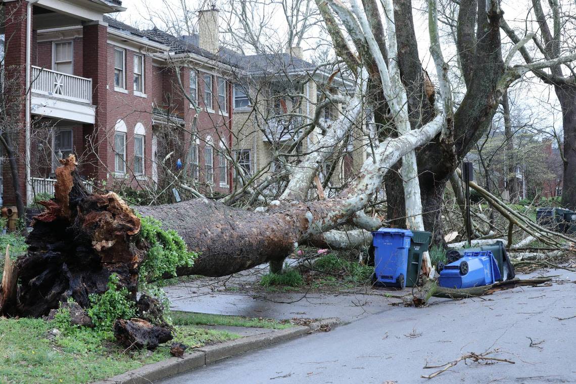
Woman injured after tree falls on Lexington home
10:30 a.m. – A woman in Lexington was sent to a hospital after a tree fell on her home, according to the Lexington Fire Department.
The incident happened on the 800 block of Melrose Avenue. District Major Derek Roberts said a large tree fell on a home, causing heavy damage to one home and additional damage to three other homes.
A woman from the house that the tree fell on was injured and transported to a hospital, according to Roberts. Her injuries were described as non-life-threatening.
Lexington police Lt. Dan Truex said there were four other individuals in the home when the tree fell on it but they were uninjured.
All four homes were deemed unsafe, Roberts said.

Lexington roads blocked because of trees, downed power lines
10:55 a.m. — There are other roads that are blocked due to storm damage whether from fallen trees or downed power lines. Across the city they are:
Alexandria Road in area of Old Frankfort Pike
Fontaine Road near Desha Road
Alexandria Drive near Our Native Lane
Romany Road near Hart Road
Parkers Mill Road near Traveller Road
I-75 in Lexington shut down due to storm damage
10:15 a.m. – A section of I-75 in Lexington is blocked off due to downed wires and storm debris in the road, according to the Lexington Traffic Management Center.
Both northbound and southbound lanes of the interstate are shut down just north of the Athens Boonesboro exit – mile-marker 104 – due to storm damage in the road. The traffic management center said police are planning on rerouting northbound travelers to exit 99 and southbound travelers to Man O’ War Boulevard.
UPDATE FOR I-75 IN FAYETTE CO:
- The roadway is fully back open. https://t.co/7ESof3IJZ9— lexwrecks (@lexwrecks) April 2, 2024
NWS: Major storm passing through region, advisories set to expire
10 a.m. – A major storm passed through Lexington and the Bluegrass Region Tuesday morning, which prompted tornado and severe thunderstorm warnings.
In the forecast discussion, NWS meteorologists said the storm is expected to depart the area around 10:30 a.m. All of the warnings and advisories are expected to be cleared once the storm departs.
However, the NWS wants to make the point that the all-clear has not been given.
“We still have an incoming cold front this afternoon, and plenty of time for the atmosphere to reload to support dangerous storms. Damaging winds, large hail and fast-moving, possibly strong tornadoes will all be possible,” the NWS said in the forecast discussion. “Anyone in southern Indiana or central Kentucky will need to stay weather aware for the rest of today.”
Thousands without power in Lexington after storm hits
9:45 a.m. — Over 10,000 LG&E & KU customers in Fayette County are without power after a strong thunderstorm hit the area Tuesday morning, according to the electric company’s power outage map.
Large outages reported in the Chevy Chase area, the neighborhoods in between Man O’ War Boulevard and the Lexington reservoir and the Cardinal Valley neighborhood.
TRAFFIC ALERT:
Trees and electric wires reported to be down in various areas of Lexington. Various roadways also reported to be blocked. See current KU outage map below. pic.twitter.com/OUonBlZMAH— lexwrecks (@lexwrecks) April 2, 2024
Lexington under severe thunderstorm warning
9:15 a.m. — The NWS has issued a severe thunderstorm warning for Fayette County along with Clark, Garrard, Jessamine, Madison and Mercer counties.
At 9:15 a.m. a radar spotted a severe thunderstorm from Dunbar High School to Nicholasville moving east at 50 miles per hour, according to the NWS. Wind gusts up to 60 miles per hour are possible with the storm.
The advisory is scheduled to expire at 10:15 a.m., according to the NWS.
Storm damage reported in Western Kentucky
9 a.m. — At 7 a.m. there was a dangerous line of severe storms spotted in Western Kentucky moving eastward. There was a report of a tree that fell and destroyed a mobile home in Union County, according to the NWS. One person suffered minor injuries in the incident.
There were also reports of roof damage and downed trees and power lines in McCracken County.
Flood, tornado watch issued for Lexington
7 a.m. — The NWS has issued a tornado watch for parts of Central Kentucky, including Lexington, until at least noon Tuesday.
The NWS also has issued flood watch for Bourbon, Clark, Fayette, Franklin, Harrison, Henry, Nicholas, Scott, Trimble and Woodford counties until at least this evening. Rainfall amounts are expected to be around 1.5-2 inches, possibly up to three inches locally.
A tornado watch has been issued for parts of Indiana and Kentucky until 12 PM EDT pic.twitter.com/crANANucuO
— NWS Louisville (@NWSLouisville) April 2, 2024
After the storms pass a cold front is expected to push through the region, dropping the temperatures as low as 30 degrees, according to the NWS. Multiple rounds of rain/snow mix are possible Wednesday night into Thursday morning east of I-65.
The NWS said a snow dusting can’t be ruled out but a significant snow even is not expected. It will also be windy Wednesday into Thursday, with wind gusts topping out around 35 miles per hour.
️️Severe storms will move through the region today. There is a threat for damaging winds, large hail, and tornadoes.
Stay weather aware today and have more than one way to receive a warning.
Wednesday night there is a chance for flurries as temperatures cool. #kywx #inwx pic.twitter.com/fJQHy2Obcs— NWS Louisville (@NWSLouisville) April 2, 2024
