Kentucky storms: 11 tornadoes confirmed, thousands still without power in Kentucky
Live updates for this story has concluded. For the latest information about the April 2 storms, visit kentucky.com.
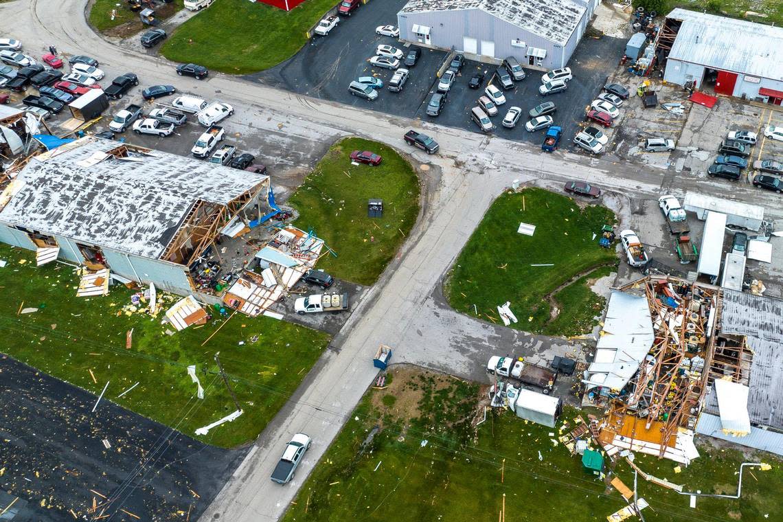
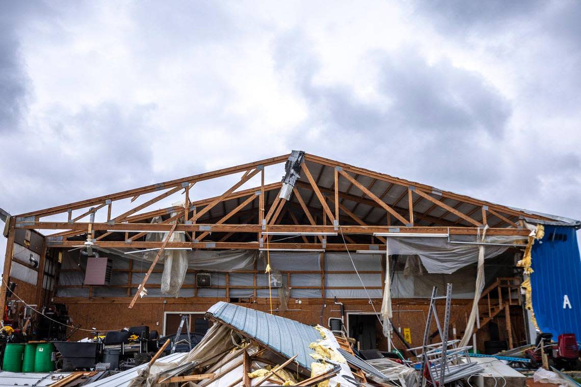
The National Weather Service has confirmed 10 EF-1 tornadoes touched down in Kentucky during Tuesday’s storm, along with one stronger EF-2.
Wednesday evening, the National Weather Service Louisville office said an EF-1 tornado reaching 100 miles per hour hit Clark County during the storms. The impact was about five miles southwest of Winchester.
In addition to an EF-1 tornado previously reported in Boyd County, the NWS Charleston, West Virginia, office said an EF-2 tornado also struck the county near Long Branch. Maximum reported speeds were 120 miles per hour.
The nine other confirmed tornadoes were in Anderson, Bourbon, Boyd, Henry, Jessamine, Jefferson, Mason, McCracken and Nelson counties. The wind speeds of the tornadoes in Anderson and Nelson counties reached 95 miles per hour while the tornadoes in Jessamine County and Henry County reached 110 miles per hour. The tornado in Jefferson County had wind speeds of 100 miles per hour, and the tornado in Bourbon County had wind speeds of 110 miles per hour.
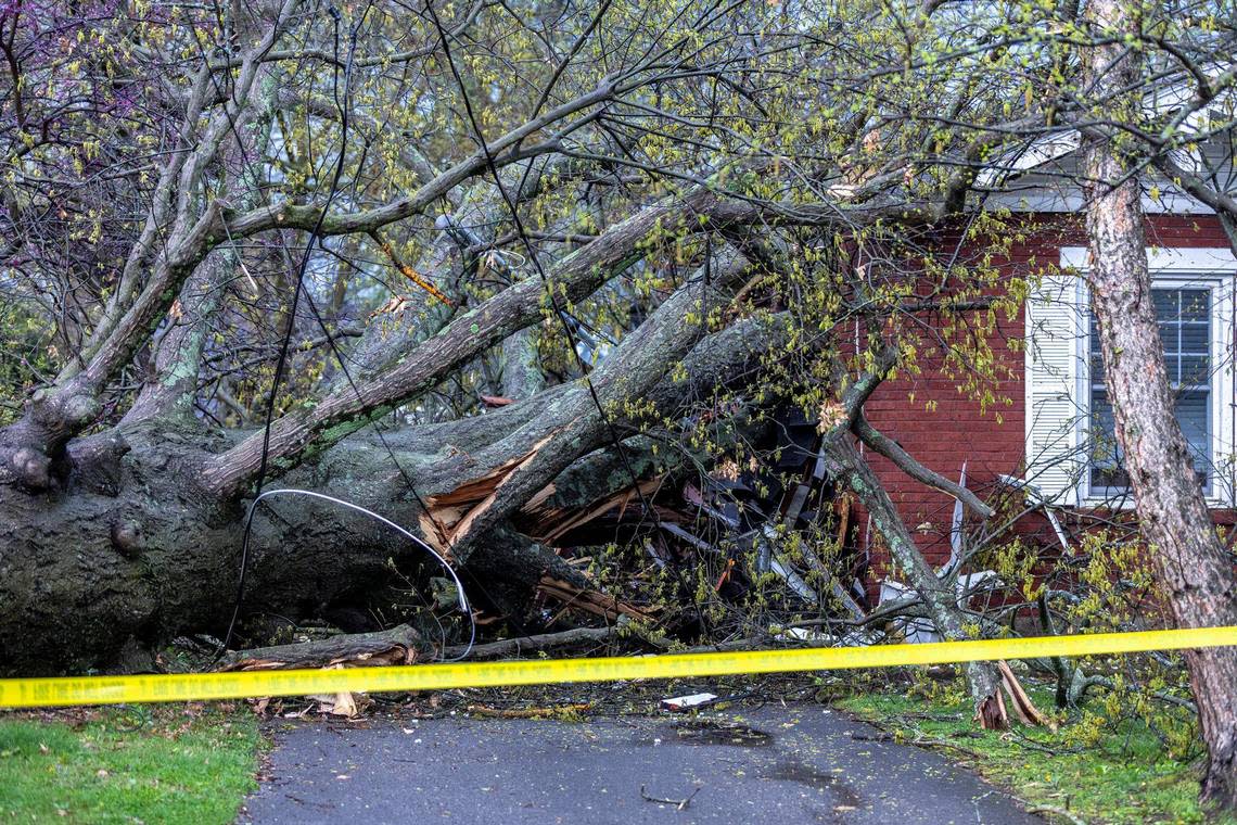
Gov. Andy Beshear said at a press conference Wednesday the state had learned of one weather-related death from Tuesday’s storms. The death was a result of a car accident in Campbell County “when the first line of strong storms” came through, and Beshear said he the victim was a young man.
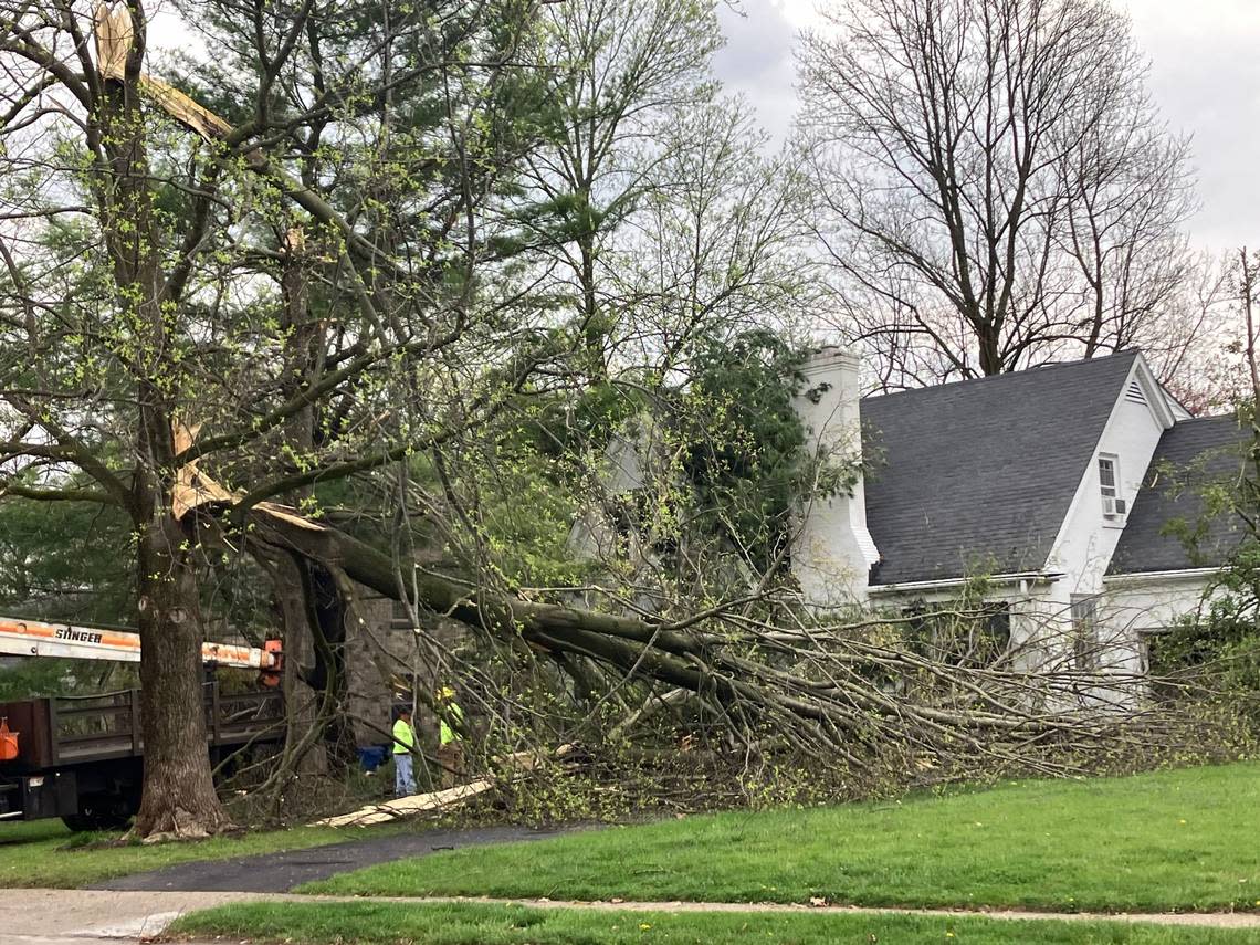
A storm report in the NWS’ Storm Prediction Center said photos submitted by the Boyd County Emergency Management Agency showed tornadic damage from at least an EF-1 tornado. Two mobile homes were displaced and multiple trees were uprooted or snapped.
The NWS also confirmed straight-line wind damage in Fayette, Mercer, Spencer and Woodford counties.
[UPDATED 6 AM 4/3/24] Here is our current planned survey map for the storms from April 2nd. The locations of surveys will likely change as we receive additional information, and all survey information is preliminary at this time. #INwx #KYwx pic.twitter.com/h2yHrWOBXf
— NWS Louisville (@NWSLouisville) April 3, 2024
One weather-related injury was reported in Lexington, Mayor Linda Gorton said Wednesday morning. The Lexington Police Department reported six injury collisions, 47 non-injury collisions and 100 traffic hazards overnight.
Lexington, Kentucky power outage map
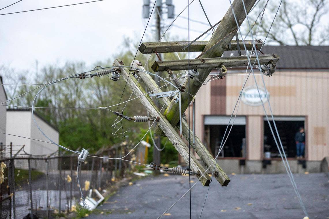
Approximately 3,700 people in Kentucky are still without power as of 6:15 a.m. Thursday., according to poweroutage.us, a website that tracks power outages nationwide. Carter County is the only county in Kentucky reporting over 1,000 outages. Fayette County has 734.
LG&E & KU’s power outage map shows 19 outages impacting 802 customers in their coverage area. Most of the outages are in the neighborhood near Henry Clay High School, and power restoration estimations for those outages are 1 p.m. Thursday.
There were a couple of outages in the Cardinal Valley neighborhood, according to the power outage map. Power restoration estimations for those outages ranged from 8 a.m. to 1 p.m. Thursday.
Fayette County residents are encouraged to submit reports of damage to their home or property to Survey123. The Lexington Emergency Management Agency said submitting damage reports helped officials see where resources are most needed.
Shortly after 9:30 p.m. Tuesday Lexington emergency management deactivated its operation center and moved to virtual operations.
If you have storm damage to your home or property, you can report it using Survey123! It only takes 30 seconds and helps Lexington see where resources are needed most. To report storm damage: https://t.co/H4DpzaAPDF
You can learn about Survey123 here: https://t.co/wfI3fNFFC6 pic.twitter.com/9XPJVNXdmh— LexingtonKY EM (@LexKYEM) April 2, 2024
Gov. Andy Beshear declared a state of emergency Tuesday after the first round of the storms left behind significant damage in many areas. There are damage reports out of Anderson, Bath, Ballard, Bourbon, Boyd, Carter, Clark, Elliott, Fayette, Greenup, Kenton, Jefferson, Jessamine, Mercer, Montgomery, Nelson, Powell, Union and Woodford counties, according to Beshear.
Kentucky, following the severe storms, I have spent all day on the phone with emergency management and local officials. I have been out of state with my family on my son’s baseball trip and am returning to provide an update on our response efforts. 1/2
— Governor Andy Beshear (@GovAndyBeshear) April 3, 2024
Lexington weather forecast
There is no severe weather in the forecast for Wednesday or the rest of the week. The NWS said the cold front has moved in, dropping temperatures by 25-30 degrees compared to the past few days.
Rain showers are expected later Wednesday morning into the afternoon hours and isolated thunderstorms featuring gusty winds and small hail are possible, according to the NWS. Wind gusts could reach 30-35 miles per hour outside of the storms.
Later in the evening rain showers could mix with or change to light snow showers, according to the NWS. A few areas could get a light dusting of snow but no measurable accumulations are expected.
Much cooler temperatures are expected today with widespread showers developing later this morning through the afternoon. A few thunderstorms are also likely this afternoon, with gusty winds and small hail possible in a few storms. NW winds will remain strong today. #KYwx #INwx pic.twitter.com/e4mHPRXMzo
— NWS Louisville (@NWSLouisville) April 3, 2024
How to get rid of storm debris in Lexington
From Wednesday through Sunday, Lexington residents can dispose of storm debris for free at the Haley Pike landfill (4216 Hedger Lane), or at the training pad on Old Frankfort Pike (1631 Old Frankfort Pike).
Both locations are open from 8 a.m. to 5 p.m. each day. A Fayette County driver’s license or other proof of Fayette County residence is required.
For those who are unable to transport their debris to the drop-off sites, it can be left at the curb for collections. Debris should be stacked between the sidewalk and curb. For those who have city garbage pick-up, it can be left at the curb for pick-up during normal weekly service, and should be cut into 4-foot sections.
For those who do not have city pick-up, or if the debris cannot be cut into 4-foot sections, a pick-up can be scheduled by calling 311. Debris cannot be larger than 12 feet long and 16 inches in diameter.
See pictures, videos of storm damage around Lexington and Kentucky
