Hurricane Idalia continues to strengthen as it nears Florida coast
CLICK HERE FOR THE LATEST UPDATES
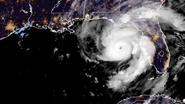
The National Hurricane Center said Hurricane Idalia continued to strengthen late Tuesday evening. The storm is recording top sustained winds of 110 mph, making it a Category 2 hurricane on the verge of reaching Category 3 wind speeds of 111 mph.
Forecasters say the storm may reach Category 4 intensity before landfall, with wind speeds of at least 130mph.
The hurricane is about 185 miles south of Tallahassee, Florida, moving northward in the Gulf of Mexico at about 18 mph, approaching Florida's Gulf Coast.
Outer bands of the storm were passing over coastal cities in Florida by Tuesday evening. Landfall is expected on Wednesday morning.
A hurricane warning is in effect for Florida's Gulf Coast from Longboat Key northward to Indian Pass. Tropical storm warnings have been issued in the Fort Myers area due to Idalia's outer bands.
A hurricane watch was in effect from the mouth of the St. Mary's River northward to Edisto Beach.
The National Weather Service announced a tornado watch for Taylor, Lafayette, and Dixie Counties until 6 AM on Wednesday.
On the Atlantic Coast, tropical storm warnings are in place from Sebastian Inlet, Florida, to South Santee River, South Carolina, as Idalia is expected to remain a powerful storm for some time after making landfall and moving northeast.
Before striking land, Idalia is expected to intensify rapidly and come ashore as a major hurricane, defined as at least category 3 strength, with winds of at least 111 mph. High ocean temperatures and low wind shear are both expected to contribute to the strength of the storm.
"Catastrophic impacts from storm surge inundation of 12 to 16 feet above ground level and destructive waves are expected somewhere between the Wakulla/Jefferson County line and Yankeetown, Florida," the National Hurricane Center wrote. "Life-threatening storm surge inundation is likely elsewhere along portions of the Florida Gulf Coast where a Storm Surge Warning is in effect. Residents in these areas should follow any advice given by local officials."
SEE MORE: What is the difference between a tropical storm and hurricane?
8/29 5pm EDT: Catastrophic storm surge inundation of 10 to 15 ft above ground level & destructive waves from Hurricane #Idalia are expected within the area from Aucilla River to Yankeetown, FL. Residents should urgently follow evacuation orders from local officials. pic.twitter.com/aQxnMFxGU7
— NHC Storm Surge (@NHC_Surge) August 29, 2023
The National Hurricane Center said areas of Florida's Big Bend could have a storm surge of 10 to 15 feet. A storm surge of 4 to 7 feet is expected in Tampa Bay.
On Monday, when Idalia was churning off the western tip of Cuba as a tropical storm, Florida residents were urged to prepare. Florida Gov. Ron DeSantis activated 5,500 members of the state's National Guard.
"Pretty much anybody on the west coast of Florida, I mean you could see major, major impacts so please prepare accordingly," DeSantis said.
DeSantis expanded the number of Florida counties under a state of emergency to 44.
Local officials and forecasters both say storm surge could be one of the biggest threats posed by Hurricane Idalia.
"Storm surge can be life-threatening at just 2 to 3 feet. Some of these areas are going to experience storm surge well over 7 foot. There's not a person in this room that's over 7 foot tall," Kevin Guthrie, Florida's director of the Division of Emergency Management, said.
Heath Davis, the mayor of Cedar Key, an island city on the western coast of Florida, pleaded with residents to take the risks of the storm seriously.
“We’re here to beg our citizens to heed this warning. This storm is the worst that we’ve ever seen, my family has been here for many generations. We haven't seen a storm this bad, ever.”
The National Weather Service office in Tallahassee has warned residents that the effects of the storm are expected to be unlike anything else the region has experienced. Residents are urged to finish storm preparations before the end of the day on Tuesday, and to heed evacuation orders.
Officials have noted there could be significant inland impacts, too. Tallahassee, Lake City and Gainesville are among Florida cities under inland hurricane warnings. While these areas won't deal with storm surge, there could be winds of over 74 mph and heavy rain.
The National Hurricane Center noted the storm could affect South Carolina and North Carolina, although there is little certainty in Idalia's path after it makes landfall. The Carolinas, however, should prepare for potential flooding, the National Hurricane Center said. High winds may also affect inland areas: while hurricanes lose intensity while they move over land, there will be a high probability of tropical storm-force winds over northern Florida and parts of Georgia and South Carolina.
A tropical storm warning was in effect for Sebastian Inlet Florida to South Santee River South Carolina.
Also in South Carolina, a storm surge watch covered the mouth of the St. Mary's River to South Santee River; from Beaufort Inlet to Drum Inlet; and the Neuse and Pamlico Rivers.
Heavy rainfall from the storm may push as far north as eastern North Carolina. The National Weather Service said some locations there may experience as much as 10 inches of rainfall through Friday.
Overnight and Wednesday tornado risk was expected to spread northward and toward southeast Georgia and the Carolinas.
The National Hurricane Center is also monitoring Hurricane Franklin, which could sideswipe Bermuda with tropical storm-force conditions. As of Tuesday morning, Franklin had top sustained winds of 125 mph.
Franklin is supposed to gradually weaken as it heads for the cooler waters of the North Atlantic.
8:40pm ET: A Tornado Watch is in effect for Taylor, Lafayette, and Dixie Counties until 6 AM ET. This is for any outer bands that may produce tornadoes. Please ensure you have multiple ways to receive warnings that will wake you up through the night. #FLwx https://t.co/1jO8ARULz7
— NWS Tallahassee (@NWSTallahassee) August 30, 2023
SEE MORE: Idalia not just a problem for Florida's Gulf Coast
