Ian — now a tropical storm — to impact Beaufort Co. beginning at high tide Thursday
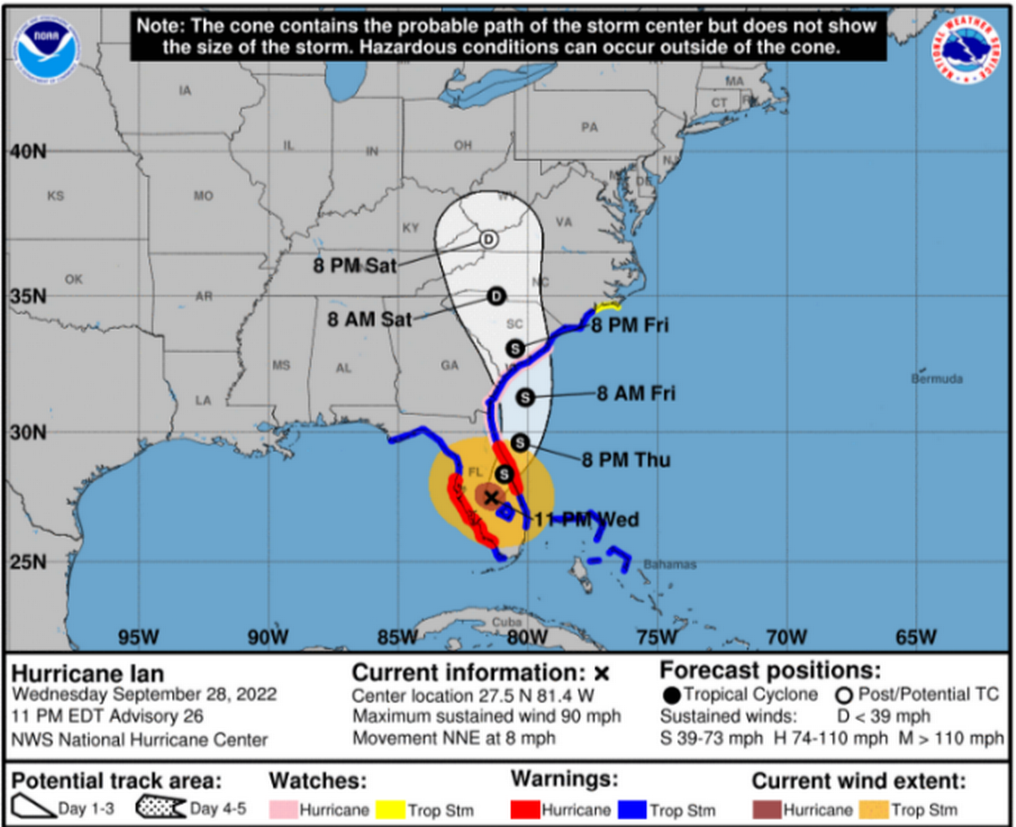
After pummeling southwest Florida as a Category 4 hurricane Wednesday and weakening overnight into a tropical storm, Beaufort County is likely to see the effects of Ian’s wake as the first round of coastal flooding was expected to hit at afternoon high tide Thursday.
Peak storm surge for the area, increased from Wednesday’s forecast, is expected to be between 4-6 feet, the National Weather Service Charleston office noted Thursday morning. Storm surge will continue to impact the county through Saturday afternoon, with the worst effects happening Friday.
Around 11 a.m. Thursday, the weather service issued a hurricane warning for all of South Carolina’s coast. A hurricane warning is issued when hurricane-force winds are expected within 24 hours, according to FEMA. Peak winds are forecast at 35-45 mph with gusts to 75 mph, but there is potential for winds 74-110 mph, the weather service’s warning noted.
According to the NWS, Ian is poised to move off the eastern Florida coast and into the Atlantic. Then, Ian is expected to turn toward the north sometime Thursday.
“It seems like each run, each six to 12 hours of model runs, seem to keep trending slightly further north and brings it further and further off our coast,” said Meteorologist Ron Morales during a Thursday morning briefing.
Morales added that if “we are lucky” and the storm continues to move more north and eastward, the tides may not be as high. He held still that residents should “prepare for high-end tropical storm to low-end hurricane conditions.”
Thursday morning, the weather service said its confidence continues to gain that Ian will make landfall along South Carolina’s southern coast Friday afternoon as a “strong tropical storm.” However, a press release from South Carolina Emergency Management Division said some forecasters believe Ian, which is currently a tropical storm, could make landfall somewhere near Charleston as a Category 1 hurricane.
As of Thursday morning, Beaufort County remained under six alerts issued by the National Weather Service.
Flood watch from 8 p.m. Thursday until 8 a.m. Saturday: Flash flooding caused by excessive rainfall is possible. Heaviest rainfall is expected Friday.
Rip current advisory until 8 p.m. Friday and high surf advisory through 8 p.m. Saturday: Large breaking waves of 5 to 8 feet in the surf zone. Swimmers should stay out of the water.
Tropical storm warning: Tropical Storm-force wind with peak wind forecast at 40-50 mph. Gusts up to 60 mph and a potential for wind 58 to 73 mph. The window of concern is early Thursday evening until early Saturday morning.
Storm surge warning: Potential for 4-6 feet above ground somewhere within surge prone areas.
Hurricane warning: The warning is issued when hurricane-force winds are expected within 24 hours. As of noon Thursday, Tropical Storm Ian had max sustained winds of 70 mph.

Warnings are issued up to 36 hours before hazardous conditions begin, while watches mean the condition is possible but not imminent.
Rainfall amounts for Beaufort County had dropped slightly from 4-8 inches to 4-6 inches by Thursday, however, localized amounts as high as 12 inches along and east of I-95 could occur, according to NWS.
The potential for tornadoes to spawn from Tropical Storm Ian’s hit did lessen from the service’s last update. Beaufort County is no longer listed as a main threat tornado area.
On Wednesday, Gov. Henry McMaster issued a State of Emergency, and an hour later, Beaufort County Council Chairman Joe Passiment declared a local state of emergency. Port Royal Mayor Joe DeVito followed suit Thursday morning. The orders are enacted to more expediently aid in disaster recovery and give the authority to order evacuations if necessary.
With Ian’s increased threat to South Carolina, a slew of closings in Beaufort County unfolded Wednesday, including schools, bridges, events and government offices.
At 3 p.m. Thursday, Beaufort County Sheriff P.J. Tanner will hold a press conference to address updates on Ian. The meeting will be streamed on the Beaufort County Sheriff’s Office’s Facebook and the County Channel.
While no evacuations have been ordered for the area, as of Thursday morning, Beaufort County said in a morning news release that more than 130 essential public works personnel are ready to provide aid across the county as long as the conditions stay as they are.
Depending on severity of damaged caused in the following days by Tropical Storm Ian, public works has $2 million in contracts to assist with cleanup and response operations, the county release said.
Island Packet reporter Karl Puckett contributed to this support.
