Hurricane Sally makes landfall near Gulf Shores, Alabama, threatening record floods
Hurricane Sally made landfall early Wednesday near Gulf Shores, Alabama, threatening record floods more than 24 hours after it began dumping heavy rain on the Gulf Coast.
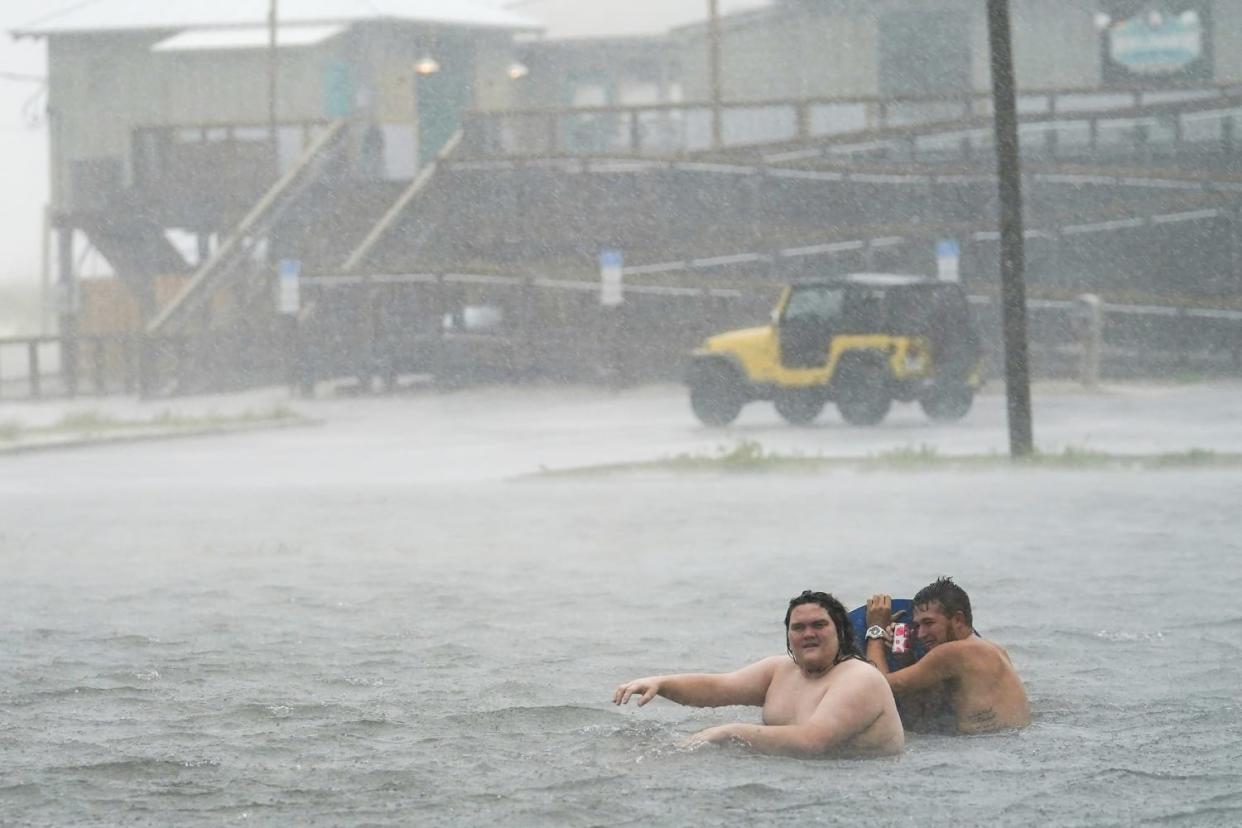
The National Hurricane Center warned Wednesday of "catastrophic" and "life-threatening" flooding along parts of the north-central Gulf Coast. Rainfall could last up to two days.
Sally made landfall as a Category 2 storm with sustained winds of 80 mph and even more powerful gusts that make lingering rainfall a major threat.
By 10 a.m. CT on Wednesday, a storm surge warning had been issued for the region between Dauphin Island, Alabama and the Walton County/Bay County line in Florida.
A hurricane warning was in effect between the Mississippi/Alabama border to the Okaloosa County/Walton County line in Florida.
And a a tropical storm warning was issued for areas east of the Okaloosa County/Walton County line in Florida to Indian Pass, Florida.
More than 150,000 customers in the area of Mobile, Alabama, woke up Wednesday to find they had lost power, Alabama Power Co. tweeted before 7 a.m. local time.
Mobile Mayor Sandy Stimpson begged his constituents to stay indoors — and of course, to stay away from fallen power poles.
"If you come across downed power lines, trees, or debris report it to 911 and do not try to touch or clear trees on your own," the mayor pleaded in a series of tweets on Wednesday.
"In the meantime, we are urging citizens in the City of Mobile to stay home. Please do not venture out unless it’s absolutely necessary."
Parts of interstates and highways were closed due to flooding and winds as officials warned people to just stay home and off any roads.
This is flooding on Bobsikes and Timberlake Drive.
NO ONE should be on the roads right now in Walton County. Conditions during #HurricaneSally are very dangerous and there is widespread flooding on roadways.
Please stay inside unless there is an emergency. pic.twitter.com/k5DJmbcZTg— Walton Co. Sheriff (@WCSOFL) September 16, 2020
"Hurricane Sally is nothing to take for granted. We're looking at record flooding, perhaps breaking historic levels, and with rising water comes a greater risk for loss of life and loss of property," Alabama Gov. Kay Ivey warned on Twitter on Tuesday.
Ivey urged residents to either prepare for possible evacuations or seek safe shelter, as the turbulent storm made headway.
Forecasters warned that areas from the western Florida Panhandle to southeastern Mississippi could see up to 35 inches of rain.
Pensacola, the westernmost city on the Panhandle, reported a storm surge Wednesday morning of about 5.5 feet.
Coastal areas near the Alabama and Florida border and east up to Florida's Okaloosa County could see storm surges of up to 7 feet, according to the National Hurricane Center.
Florida Gov. Ron DeSantis tweeted Tuesday that he had declared a state of emergency in 13 northwest Florida counties. "Floridians in these counties should prepare for strong winds and severe flooding," he cautioned.
On Monday, President Donald Trump issued emergency declarations for parts of Alabama, Mississippi and Louisiana, ordering federal assistance.
Last month, Trump got a firsthand look at damage after Hurricane Laura pummeled parts of Louisiana and Texas, leaving at least 15 dead and wreaking havoc. His visit followed a Republican National Convention trip, days after the storm slammed the Gulf Coast.
The extreme weather follows historic wildfires that swept through parts of the West Coast this month, with California state officials and experts blaming climate change and a build up of dried-out vegetation for the dozens of fires that scorched the state.
Download the NBC News app for breaking news and politics
The storm, which will begin to pick up some speed, is expected to move inland across southeastern Alabama later Wednesday and into Thursday.
Sally is also forecast to bring heavy downpours to parts of Mississippi, Alabama, Georgia and the Carolinas later in the week.
"A hurricane moving at 2 mph is stalled for all intents and purposes," Brian McNoldy, a hurricane researcher at the University of Miami, told The Associated Press. "If they aren’t moving along and they just kind of sit there, you're going to get a ridiculous amount of rain."
Forecasters warned that tornadoes were also possible Wednesday across the Florida Panhandle and southern Alabama.
Earlier in the week, Louisiana and Mississippi were bracing for Sally, but as the hurricane slightly changed course, forecasters predicted they should largely be spared from the storm.
Sally had already deluged some areas Tuesday night with more than a foot of rain.
This year's hurricane season — which won't end for another 2 ½ months — has already been one of the busiest on record. Forecasters have almost run through the alphabet of names.
Early Wednesday morning, another storm, Teddy, was rapidly upgraded to a hurricane, with sustained winds of 90 mph. The storm is still in the middle of the Atlantic, hundreds of miles from land but is forecast to become a catastrophic Category 4, possibly reaching Bermuda this weekend.
