Hurricane Nicole approaches Florida coast, lashing state with damaging surge, winds
Hours ahead of its expected landfall on Florida’s east coast, Nicole strengthened into a Category 1 hurricane Wednesday. Its storm surge and high winds had already clawed pool decks, lifeguard stands and some buildings back into the ocean.
The first round of Nicole-strengthened high tides earlier in the day ate away at beaches and dunes gnawed by Hurricane Ian in September, leading to a round of last-minute evacuations of beachfront condominiums, homes and a hotel in Daytona Beach Shores, an area already under a mandatory evacuation.
“There have been dozens upon dozens of buildings that have been declared structurally unsafe here along the beach in Volusia County,” Volusia County Sheriff Mike Chitwood said in a video update. “We are fearful that several of those structures will collapse.”
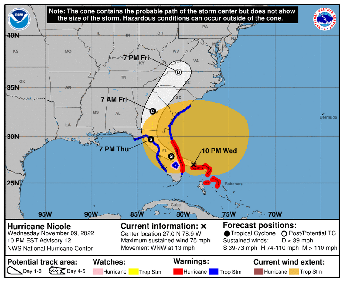
Hurricane Nicole made its first landfall in the northeastern Bahamas Wednesday afternoon, in nearly the same spot Hurricane Dorian ravaged in 2019, and another landfall Wednesday night as it swept across Grand Bahama Island. In a 10 p.m. update, the National Hurricane Center said a third landfall was expected in the overnight hours somewhere north of the Palm Beach-Martin County border. It was a path expected to spare Miami-Dade and Broward counties significant damage — though a high risk of power outages remained.
But regardless of where the center crosses the state, forecasters warned the sprawling storm’s high winds and heavy rains would be felt statewide.
Sustained tropical storm force winds started early, around 9 a.m. in Lake Worth Pier, and conditions degraded throughout the day. By Wednesday evening, severe street flooding could be spotted from Fort Lauderdale to St. Augustine, prompting road closures and some rescues. High water rescue vehicles were deployed on Hutchinson Island and lifeguards rescued several children from rip currents in Jensen Beach.
Almost 8,000 customers across Florida were already without power by Wednesday night, according to PowerOutage.us, which collects outage data from various utility companies.
Michael Brennan, acting deputy director of the National Hurricane Center, said in a Wednesday morning broadcast that the storm’s wind field stretched more than 450 miles from the center, largely to the north.
“We’re very concerned about storm surge with Nicole with that large wind field,” he said. “That’s only going to get worse as we go through today and into the night cycle.”
With storm surge and beach erosion the biggest threat, mandatory or voluntary evacuations also had been called for tens of thousands along the coast, from Palm Beach north to Volusia County. Theme parks are closed, drawbridges are locked and Orlando’s International Airport shut down as the storm drew near.
Many coastal and inland counties, including Miami-Dade, Broward and Palm Beach, closed schools Wednesday and most planned to stay closed Thursday as well.
While Nicole is likely to prove damaging and spark widespread power outages, forecasters were not expecting it to get much stronger before it sweeps across the peninsula. It is set to cross some warm ocean waters as it moves through the northern Bahamas, but forecasters said wind shear and other less friendly conditions will likely keep the storm in check and near Category 1 status.
However, the worst of the winds and flooding is expected overnight Wednesday. That means another round of supercharged high tide flooding and strong surf for coastal Florida, which already took a beating earlier in the day. The heaviest initial impact appeared to be in the Daytona Beach area.
“We’re looking for a really rough night tonight,” said Chitwood, the Volusia County Sheriff.
King tides, previous erosion from Ian raise Florida’s storm surge risks from Nicole
State, federal government ready
White House officials told the Herald that President Joe Biden was briefed on the incoming storm Wednesday morning, after signing an emergency declaration for Florida overnight at the state government’s request.
South Florida is already feeling Tropical Storm Nicole. How bad will it get?
“FEMA is closely monitoring the storm system and its potential impact on Florida, federal tribes, and the southeastern states,” said Jeremy Edwards, press secretary for FEMA.
“We also know that some areas in Florida remain vulnerable due to the aftermath of Hurricane Ian, and we stand ready to help those who may be impacted by Nicole prepare, while continuing to support those recovering from Ian,” Edwards said.
In a Wednesday morning press conference, Florida Gov Ron DeSantis said there were 16,000 line workers ready to respond as soon as conditions are safe, but residents should still prepare for power outages.
“Winds are the main concern with Nicole,” he said. “It will affect huge parts of the state of Florida pretty much all day Thursday.”
A ‘direct hit’ for the Bahamas
Nicole is now approaching Florida’s east coast after it made landfall in Great Abaco Island just before noon Wednesday as a tropical storm, the same spot where Category 5 Hurricane Dorian struck with a vengeance in 2019 leveling much of the community of Marsh Harbour.
Nicole is expected to be a far weaker storm, with 75 mph sustained winds instead of 185 mph, but residents are still prepared to see damage.
“Abaco and Grand Bahama are going to be a direct hit,” Carl Smith, permanent secretary of the disaster preparedness office, said. Residents on Abaco are expecting up to six inches of rain and six feet of storm surge, and flooding was already being reported in certain areas like Green Turtle Cay.
Eleuthera and New Providence, where the capital of Nassau is located, appear to have been given “some reprieve,” Smith said, but he reported flooding already on the west coast of the island.
Residents in the Sandyport area are experiencing flooding due to Tropical Storm Nicole. Motorists are advised to avoid the area. #bahamas #zns #theznsnetwork #ZNSTrackingNicole #weather #hurricane #hurricaneseason #tropicalstorm #tropicalstormnicole pic.twitter.com/84dgkUKkPk
— ZNS Bahamas (@ZNSBahamas242) November 9, 2022
Authorities are reporting localized flooding in some communities with eight to 10 inches of rainfall and power outages. In most cases, the power has been intentionally shut down after winds picked up. Bimini went on an island-wide shutdown at 9:35 am.
Residents were warned to stay off roads, which are unsafe and blocked on some islands. Storm surge had reached the eastern coastline and Cayes, slowing down emergency crews ready to respond or restore power.
Nicole made a second landfall, this time as a hurricane, around 6 p.m. Wednesday on Grand Bahama Island.
What to expect in Florida
In a 10 p.m. update, the National Hurricane Center said that the storm was about 20 miles north-northeast of Settlement Point, Grand Bahama Island, and 75 miles east-northeast of West Palm Beach.
Its maximum sustained winds remained at 75 mph, and it was headed west-northwest at 13 mph. It has little time to strengthen further before making landfall on Florida’s east coast.
As Nicole rolls west, most of Florida will see pounding surf and storm surge, with a peak surge of 3 to 5 feet above dry ground for the state’s northeast coast. Coastal Palm Beach and Broward counties could see 2 to 4 feet, and Miami-Dade could see 1 to 2 feet.
This surge comes on the tail end of a king tide event, one of the highest annual tides.
The west coast is also due for several feet of surge as the storm zig-zags its way inland before turning north, where it’s expected to cross through Georgia and follow the coast until it dissipates.
Tropical Storm Nicole slowly gathering strength and approaching the Bahamas. pic.twitter.com/Axh67UgziQ
— CIRA (@CIRA_CSU) November 9, 2022
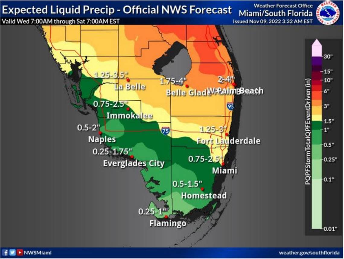
While Nicole will douse the state with several inches of rain, it’s not expected to be a dramatic rainmaker like Hurricane Ian. That’s because the storm is set to zip around the state at 15 mph, a speedy clip for a storm that prevents it from spending too much time over land and dropping too much rain.
The eastern, central and northern regions of Florida will likely receive 3 to 5 inches of rain, with local maximums of 8 inches, according to the hurricane center.
Late Wednesday night, power outages across the state were spotty. Of Florida Power & Light’s four million customers, for instance, only about 5,000 were without electricity.
FPL Spokesman Jack Eble said customers can expect the number of outages to increase as Nicole’s massive wind field makes its way to Florida. He said the utility has 13,000 workers ready at 11 staging areas across the state. While Eble wouldn’t go as far as saying it was about an average day for FPL — so far — he did say that the numbers were “quite low at this time.”
“We’re ready to respond to customers as the storm approaches,” he said.
Miami Herald staff writers Jacqueline Charles, Charles Rabin, Devoun Cetoute, and McClatchy White House correspondent Michael Wilner contributed to this article.
