Hurricane Ian barrels down on Florida after slamming Cuba
Florida braced for a potentially devastating Hurricane Ian on Tuesday night as the powerful storm whipped away from Cuba and barreled toward the Gulf Coast, threatening to unleash catastrophic coastal flooding.
The hurricane made landfall Tuesday in the island nation, blowing sustained gusts around 125 mph and sending some 50,000 evacuees spilling out of the island’s Pinar del Rio province. By the evening, parts of Havana were sapped of power and about 2.5 million Floridians were under evacuation orders.
Central Florida appeared to be facing a particularly perilous path, with the National Hurricane Center saying in a Tuesday evening advisory that life-threatening coastal storm surges were growing “increasingly likely” as the storm warmed above the Gulf Coast.
“Devastating wind damage is expected,” the advisory said. “Residents should rush all preparations to completion.”
Gov. Ron DeSantis said Floridians still had “some time” to move before the full brunt of the storm strikes his state Wednesday.
“But that time is rapidly running out,” DeSantis said Tuesday night.
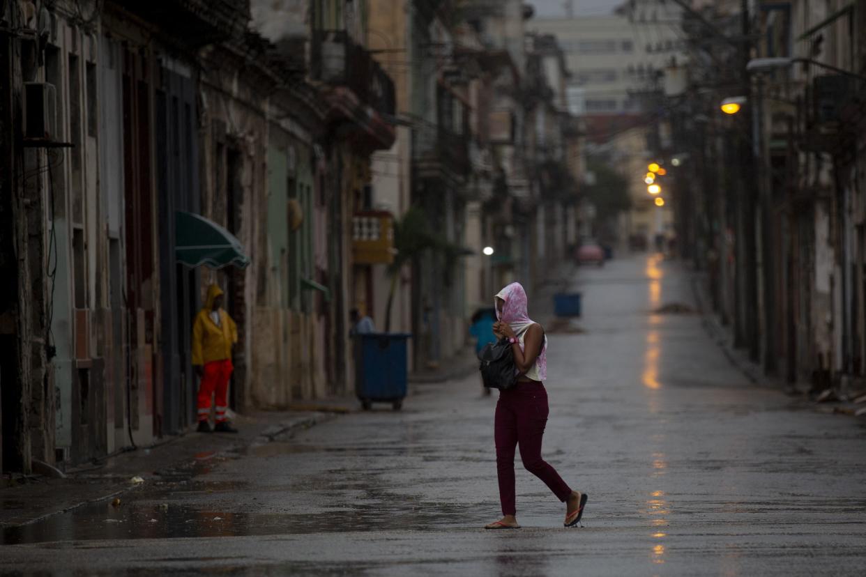
A pedestrian crosses an empty street during the passing of Hurricane Ian in Havana, Cuba, early Thursday, Sept. 27, 2022. (Ismael Francisco/)
The slow-moving storm hovered for hours over Cuba, lashing the island’s western coast with significant wind and storm surge impacts before turning toward Florida.
On Tuesday night, the hurricane remained at Category 3, with winds at 120 mph. But it was projected to potentially reach Category 4.
President Biden said he spoke with the mayors of three cities squarely in the crosshairs — Clearwater, St. Petersburg and Tampa — and urged them to contact him directly with any requests. The federal government had already sent 700 first responders and secured 3.7 million meals, the commander-in-chief said Tuesday afternoon.
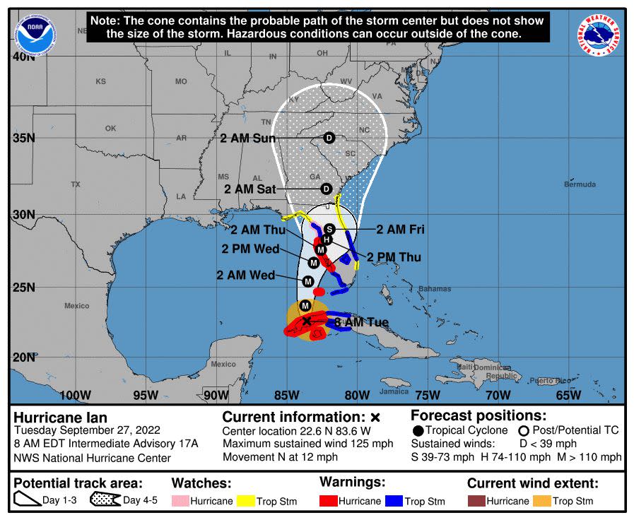
Ian is expected to dump between 12 to 16 inches of rainfall with maximums up to 24 inches in Tampa and West Central Florida. Forecasters also warned the surge could reach 10 feet if it peaks at high tide.
“Citizens in the potential impact area should obey the instructions of local officials: Evacuate when ordered, and be prepared for the storm when it comes,” Biden said in remarks at the White House Rose Garden. “Your safety is more important than anything.”
DeSantis also urged Floridians to prepare for major power outages that could last days. He said the storm was projected to strike Florida initially on the southern edge of Sarasota County sometime Wednesday, according to the latest forecast.
Ian was expected to meander across Florida from Wednesday to Friday, not exiting until that morning near the state’s northeast.
“This is going to be a lot of impacts, and they will be felt far and wide throughout the state of Florida,” DeSantis said at a news conference Tuesday evening. “It is going to produce major, major flooding.”
The storm will weaken over Florida, he said, but it will also slow down, drenching the state with rain.
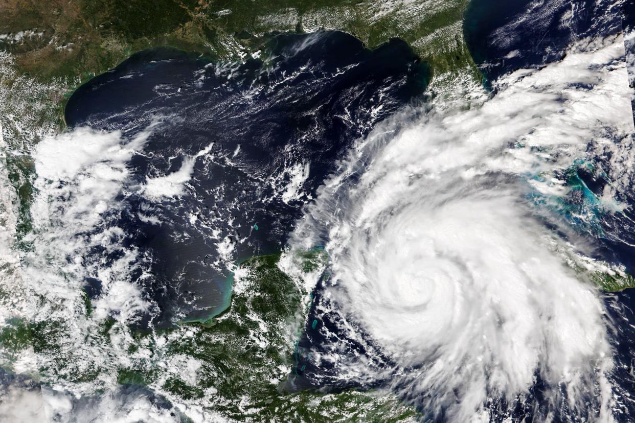
This Sept. 26, 2022, satellite image released by NASA shows Hurricane Ian growing stronger as it barreled toward Cuba.
The storm’s approach triggered hurricane warnings from Chokoloskee, south of Naples, to the Anclote River, north of Tampa. A tropical storm watch was also in effect for the Middle Florida Keys and other portions of the state’s east and west coasts.
Though Ian’s winds make it a Category 3 storm, the biggest threat to central and northeast Florida may be the rain. Up to 24 inches of precipitation could fall in some of those areas, according to the National Weather Service. The Florida Keys and South Florida could see up to 12 inches, while eastern Georgia and South Carolina were told to prepare for similar totals.
DeSantis declared a state of emergency in all 67 Florida counties, with 26 school districts across the state closed in anticipation of the storm. Disney World closed Tuesday. Thousands of people were being evacuated from hotels and campgrounds in Orlando, with portions of the amusement park already plagued with flooding.
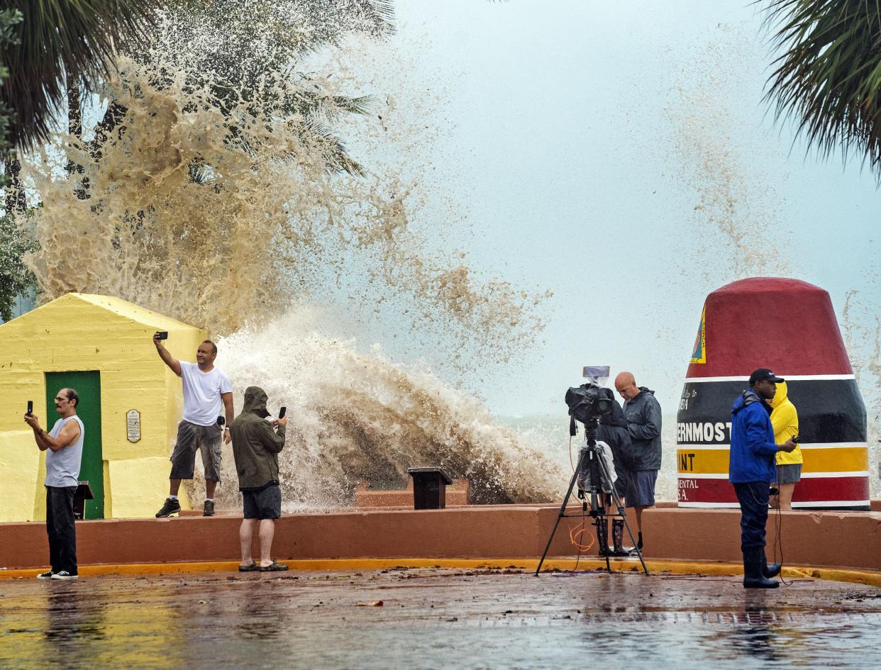
News crews, tourists and local residents take images as high waves from Hurricane Ian crash into the seawall at the Southernmost Point buoy, Tuesday, Sept. 27, 2022, in Key West, Fla. (rob oneal 305 942~1299/)
Biden also declared a state of emergency ahead of Ian’s arrival, authorizing the Department of Homeland Security and the Federal Emergency Management Agency to coordinate disaster relief and provide assistance to protect lives and property.
He said DeSantis has activated the state National Guard, with 2,000 National Guard responders also coming in from outside states.
Several airports have begun to shut down along Florida’s Gulf Coast. Orlando International Airport said it would close shop at 10:30 a.m. Wednesday. More than 600 total flights were canceled. Tampa International Airport shut down at 5 p.m. Tuesday, resulting in about 400 cancellations for Wednesday.
Sarasota, Clearwater-St. Pete and Key West airports also closed. Miami International remained open, but hundreds of flights were canceled because of the storm’s projected path.
In the sports world, three college football games moved to different times or locations, with the Florida Gators and South Carolina Gamecocks both altering their schedules in anticipation of the storm. The NFL’s Tampa Bay Buccaneers, scheduled to host the Kansas City Chiefs on Sunday night, left their home city to practice in Miami all week.
With News Wire Services
