Hurricane Hilary: California, Arizona and Nevada prepare for potential flooding as storm approaches
Residents of the Southwestern United States are bracing for potential flooding with Hurricane Hilary set to make landfall over the weekend.
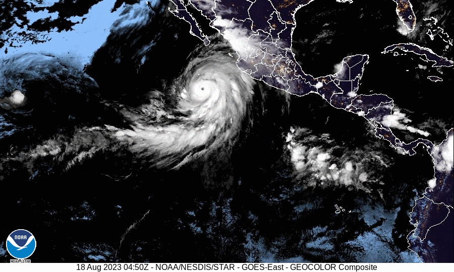
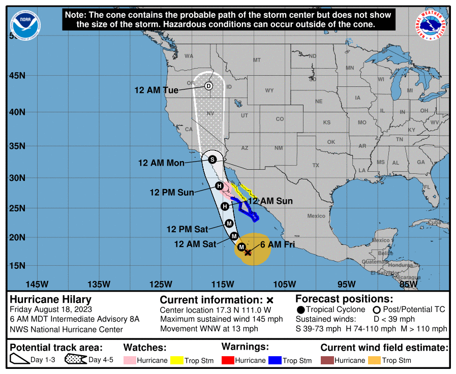
Hilary reached Category 4 status on Friday, but meteorologists expect it to weaken to a tropical storm by the time it makes landfall and passes over the Baja California peninsula of Mexico. But even a tropical storm would be historic, as one has not struck California since 1939.
“Heavy rainfall in association with Hilary is expected to impact the Southwestern United States through next Wednesday, peaking on Sunday and Monday,” reported the U.S. National Hurricane Center. There are also concerns about damage from high winds in the affected areas.
On Friday, a tropical storm watch was issued for parts of Southern California — the first ever for that region.
Related: What you should do in a flooding emergency, according to experts >>
California's Office of Emergency Services announced Thursday it was “already actively coordinating an early, unified and orderly response." California was already pummeled by rain earlier this year caused by numerous atmospheric rivers.
Potential danger across the region
In Southern California, residents of San Diego and Riverside counties have been warned to prepare for up to 10 inches of rain. The city of San Diego averages 0.01 inches of rain in August, and forecasters say the coming deluge could break the August record of 2.13 inches, which was set in 1851. The only recorded instance of the city being hit directly by a hurricane came in 1858.
The National Weather Service has a flash flood warning in effect for the region from Saturday morning through Monday. Surfers are also monitoring the conditions, with lifeguards along the Pacific coast preparing to clear beaches if lightning hits in the area. Heavier rain is expected to reach the Los Angeles area on Sunday.
On Thursday, the NWS warned residents of the Palm Springs/Coachella Valley area to prepare for potentially more rain than the region would receive in a normal year. Meteorologist Miguel Miller warned residents to stay at home Sunday and Monday due to the potential of flash floods, saying, “We don’t expect the 5 to 6 inches in the valley to fall nice and evenly over three days.”
Las Vegas residents are prepping for flooding and flight delays over the weekend, with the usual August rainfall of 0.32 inches potentially tripled by the effects of Hilary. This comes after the hottest July on record for the city. The hurricane center warned that southern Nevada is among the areas at particular risk, along with western portions of Arizona, which have flood watches in effect.
The potential damage comes with the Federal Emergency Management Fund disaster fund nearly depleted after the wave of billion-dollar climate disasters already this year. FEMA has urged Congress to pass a new spending bill to make up for the difference.
A run of 'historic' flooding
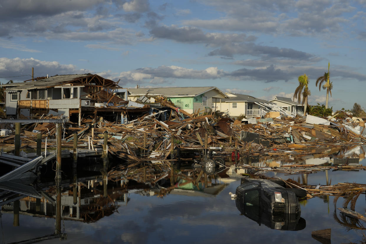
The Southwest United States could follow in a string of destructive flooding events across the country. Hurricane Ian devastated Florida last September, cutting a path from the Gulf Coast up through Orlando and the center of the state that resulted in at least 150 deaths. Gov. Ron DeSantis said that Sanibel Island was “destruction” and that it had been hit by a “biblical storm surge,” calling it “basically a 500-year flood event.” Weeks later, a rare November hurricane caused flooding up and down the Atlantic coast, damaging Daytona and Vero Beach.
Although it wasn’t caused by a hurricane, Vermont suffered its worst flooding in more than a century in July, with Gov. Phil Scott calling the damage “historic and catastrophic” as the capital city of Montpelier was completely flooded. At the same time, parts of New York were hit with levels of rain and flooding Gov. Kathy Hochul described as a “1-in-1000-year weather event.” Last summer, extreme flooding in eastern Kentucky killed more than 40 people, and an emergency declaration was made in July amid heavy rains.
Due to climate change, the rate of once-in-a-century weather events is likely to increase.
“Those numbers indeed ignore the fact that climate change has made these events far more frequent,” Michael Mann, director of the Center for Science and Sustainability and the Media at the University of Pennsylvania, told Yahoo News in July. “While the numbers will have to be crunched to look at the specifics of this event, we know there are many other one-in-a-thousand- or even one-in-tens-of-thousand-year events (like the 2021 Pacific Northwest heat dome) where something that simply wouldn’t have occurred in the absence of human-caused warming is now becoming a regular occurrence.”
