Wintry mix lingering in Milwaukee
A mixture of rain and snow flurries fell on Milwaukee Wednesday morning, as a weather system lingered in Wisconsin.
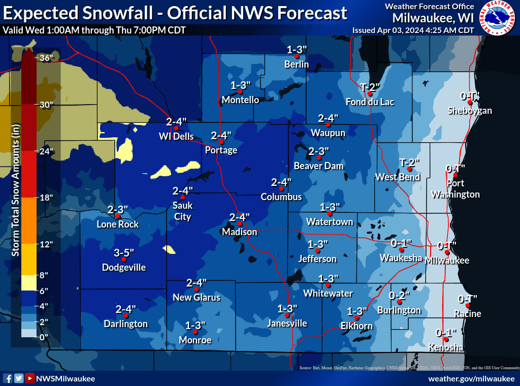
The National Weather Service office in Sullivan expects the system to continue to drop intermittent snow and rain in the area through the evening. The latest snowfall forecast from the NWS shows that Milwaukee is expected only to get trace amounts of accumulation, with up to 1 inch further west in Waukesha, as the day's temperatures, sun angle and low snowfall rate hampered accumulation.
"There's going to be some lingering snow showers here for the next couple of hours," said Cameron Miller, a meteorologist at the Milwaukee NWS office. "It should give way to more misty precipitation and then this afternoon when it's looking like the possibility of some rain and snow showers kind of hit or miss variety here."
Miller said the system is lingering in the area longer than what the office's models initially forecasted. The weather system is currently spiraling in the jet stream and should head to the northeast by evening.
Steady snowfall early this morning will weaken, becoming light by late morning. Light snowfall will continue through tonight, but any additional accumulations beyond noon will be minor. #wiwxpic.twitter.com/mf5kQqSdjM
— NWS Milwaukee (@NWSMilwaukee) April 3, 2024
Overnight, northern and central Wisconsin faced widely ranging amounts of snow. Paired with heavy winds, drifting snow accumulated on roads, but mild temperatures were expected to melt snow through the day.
The snowstorm left more than 60,000 Wisconsin residents without power, primarily near Green Bay and further north and west, according to the Wisconsin Public Service outage map.
"It was quite interesting here in Green Bay," said Roy Eckberg, a meteorologist at the NWS Green Bay office. "We had a very heavy snow in the evening, one to two inches per hour. We had some thunderstorms in the Green Bay vicinity to add to the excitement."
Eckberg said that snowfall totals near Green Bay ranged from just 1.5 inches to about 6 inches, in initial morning reports. Heavy winds made snow measurements difficult, as gusts reached up to 56 miles per hour, he said.
Near La Crosse, with the temperature at or near freezing and the variable elevations in the area, snow accumulation reports varied dramatically. At the National Weather Service La Crosse office, 14 inches was recorded, while the La Crosse Regional Airport recorded under two inches, said Todd Shea, a meteorologist at the La Crosse NWS.
"Only because you get a lot of melting going on and some elevation differences going on, making reports very varied," he said. "At times the heavy snow, it (fell) at least an inch an hour, sometimes closer to two."
Early morning snowfall reports from the NWS showed 4.2 inches in Plover, a central Wisconsin village; 6.3 inches in Verona, a suburb of Madison; and 7.3 inches in the nearby Mayville.
Overnight snowfall reports from other parts of the state had yet to trickle in on Wednesday morning, however Tuesday night snowfall in Greenville, near Appleton, was recorded at 8 inches at 10:20 p.m. Further north, in Pulciver, 9.5 inches was reported at 10 p.m.
Milwaukee was largely spared from snow accumulations overnight but was battered with wind and rain throughout Tuesday and into Wednesday. The Milwaukee area received 1.38 inches of rain, according to the NWS.
To the west and northwest of the city, the NWS was maintaining a winter weather advisory through 1 p.m. with forecasts of about 1 inch of snow in Waukesha and up to 4 inches near the Wisconsin Dells and Dodgeville. Madison was forecasted for an additional 2 to 3 inches of snow.
Lots of weather "headlines" out there this morning so use caution if you have travel planned, especially in Wisconsin. Winter Storm Warnings/Advisories, plus Wind Advisories. pic.twitter.com/gwv6Cfj7i8
— NWS La Crosse (@NWSLaCrosse) April 3, 2024
Around the state, the NWS winter storm warnings and winter weather advisories will continue into the early afternoon.
Shea, the La Crosse meteorologist, said the storm has stalled just to the east of Wisconsin and that could mean lingering snow and heavy winds to the eastern half of the state.
Areas of snow will continue through sunrise with gusty northerly winds and reduced visibility. Use caution as some roads are slick, and be alert for fallen tree branches where more snow has fallen, especially as winds increase. pic.twitter.com/gSzlYKQKph
— NWS La Crosse (@NWSLaCrosse) April 3, 2024
Throughout the entire state, roads were slippery from the night's snow, according to the 511 Wisconsin travel information website.
In northern Wisconsin, near Marinette, a small portion of state Highway 180 south was closed from an early morning incident and another morning incident closed a section of U.S. Highway 41.
Light snow and strong winds will continue to impact all of northeast WI this morning. Additional snow accumulations to range from less than an inch west of Highway 51 and near Lake Michigan, with 1 to 2 inches expected elsewhere. Roads will remain slushy and slippery. #wiwxpic.twitter.com/7b19VZmf7j
— NWS Green Bay (@NWSGreenBay) April 3, 2024
Wisconsin weather radar
Wisconsin weather warnings
This article originally appeared on Milwaukee Journal Sentinel: Heavy snow and winds continued in Wisconsin overnight
