Forecasters predict high probability for severe thunderstorms Friday in northeast Kansas
A strong storm system is expected to rain on central Kansas on Thursday and the state's eastern half on Friday, the National Weather Service says.
"These storms are likely to be severe with the greatest probability for severe thunderstorms over northeast Kansas on Friday," the weather service's Topeka office said Monday on its website.
Hail, tornadoes, high winds and flooding may all be possible, it said.
Forecasters still don't know "exact location and timing of these storms based on differences in the track and timing of the system," the Topeka office's website said.
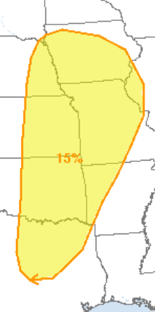
Storms possible in nation's central and southern plains
The weather service's Storm Prediction Center in Norman, Oklahoma, predicted on its website a 15% chance that severe storms could develop Friday within 25 miles of any given point in a large part of the nation's central and southern plains, including the eastern of the state of Kansas.
"A few supercells with large hail and wind damage" are possible Friday in that area, that site said.
"An isolated tornado threat could also develop," it said.
Contact Tim Hrenchir at threnchir@gannett.com or 785-213-5934.
This article originally appeared on Topeka Capital-Journal: Severe storm system considered likely Friday to affect eastern Kansas
