Tropical Depression 10 forms near Mexico. May approach Florida’s Gulf Coast as hurricane
Tropical Depression 10 has formed near Mexico and it has Florida in its sights, the National Hurricane Center said. It will likely approach the state’s Gulf Coast sometime next week, becoming a hurricane as it moves over the Gulf of Mexico.
Although the system is days away from being near Florida, parts of Cuba and Mexico have been put under tropical storm warnings and watches as it looms nearby.
The depression is about 70 miles east-northeast of Cozumel, Mexico, with maximum sustained winds at 30 mph.
As of the NHC’s 8 p.m. advisory, it was meandering over the Yucatan Channel moving northwest at about 1 mph. Forecasters say it won’t be picking up any steam until Monday.
Do we know what parts of Florida will be affected?
The depression is forecast to strengthen during the next few days making landfall somewhere near Florida’s Panhandle as a possible hurricane sometime between Tuesday and Wednesday.
It is still too early to narrow down the track. Forecasters warn that there is significant uncertainty over where the system will be or how strong it will get three to four days from now.
At play in the Gulf of Mexico were two major and conflicting forces: sea surface temperatures in the high 80s, far warmer than usual that can fuel development, but also a swath of storm-shredding wind shear. If it can skirt the shear and stick to the hot waters, a low-strength hurricane could be a threat.
However, if it becomes a hurricane it will bring potentially dangerous storm surge, heavy rainfall and strong winds to portions of Florida’s west coast and Panhandle — a region still recovering from devastating Hurricane Ian last year. The southeast U.S. is also likely to see heavy rainfall late next week.
While it still hasn’t earned a name, which would be Idalia, Gov. Ron DeSantis already issued a state of emergency for 33 counties along Florida’s Gulf Coast.
“I encourage Floridians to have a plan in place and ensure that their hurricane supply kit is stocked,” he said in a statement.
I’ve signed an executive order declaring a state of emergency for 33 counties in preparation for Invest 93L. Issuing this order today ensures communities have time to prepare for the storm system which could have impacts along the Gulf Coast next week.
Floridians should have a…— Ron DeSantis (@GovRonDeSantis) August 26, 2023
How will the depression affect Cuba, Mexico?
Cuba and Mexico are currently facing the threat of the depression, which is forecast to become a tropical storm on Sunday.
A tropical storm warning is in effect for Yucatan Peninsula from Tulum to Rio Lagartos, including Cozumel. A tropical storm watch is in effect for Pinar del Rio, Cuba, and the Isle of Youth.
Western Cuba could see 4 to 8 inches of rains, with isolated maximums of up to 12 inches. Flash and urban flooding, along with landslides, may result from the downpour.
The eastern Yucatan Peninsula is in for similar showers with possible rain totals of 3 to 6 inches, with isolated higher amounts of 10 inches.
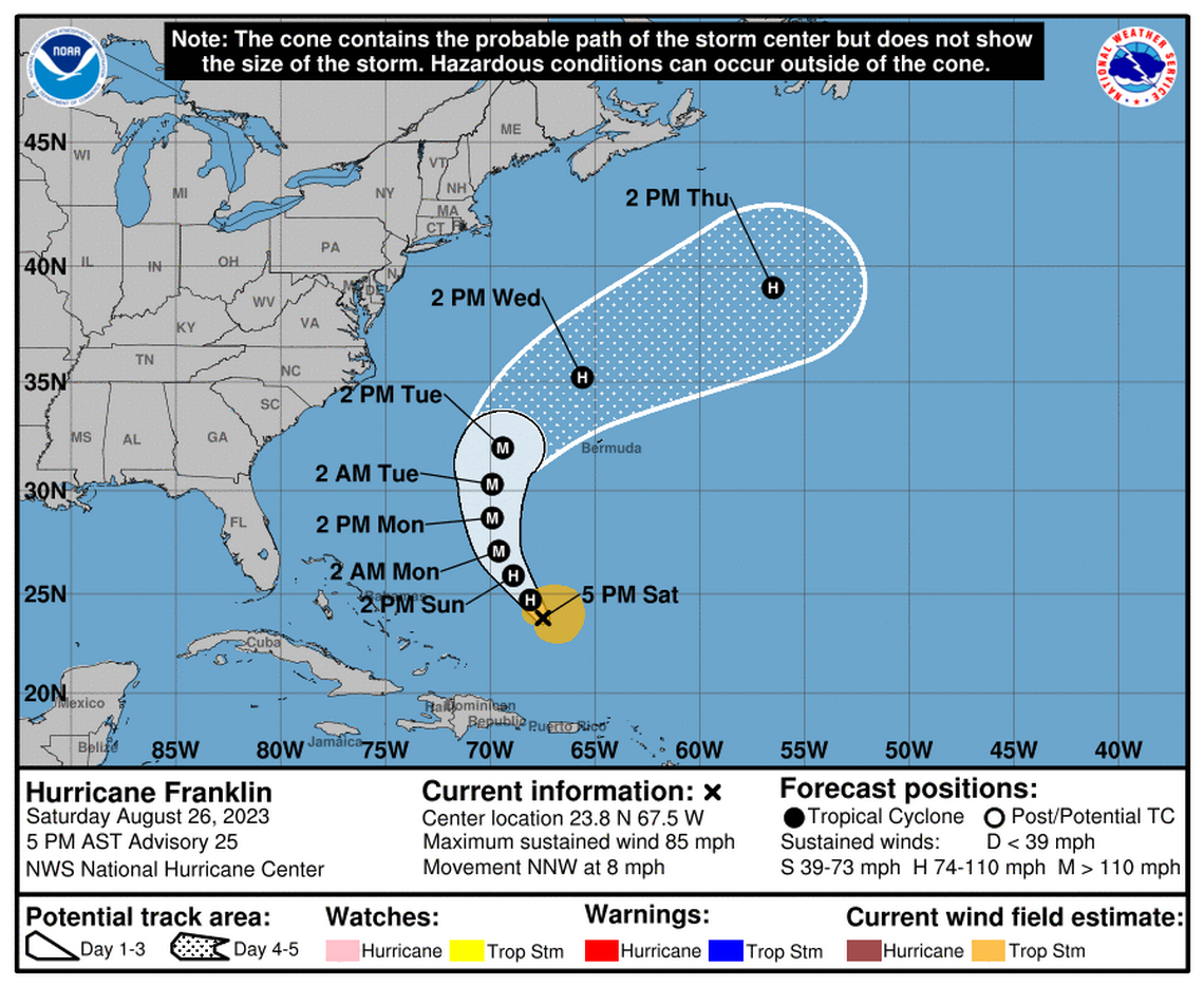
Franklin becomes a hurricane
Franklin, meanwhile, strengthened into a Category 1 hurricane Saturday morning and is continuing to grow strong, according to the NHC’s 5 p.m. advisory. It is projected to become a Category 3 hurricane early next week.
Franklin is moving north-northwest at nearly 8 mph and is expected over the western Atlantic through early next week.
Maximum sustained winds have increased to about 85 mph with higher gusts.
Franklin is expected to steadily strengthen and could become a major hurricane early next week, reaching 125 mph winds.
Hurricane-force winds are currently extending outward up to 25 miles from the center, with tropical-storm-force winds extending outward up to 140 miles.
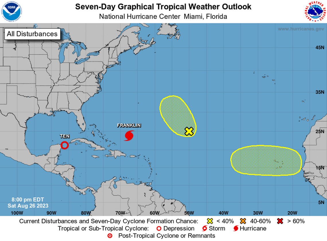
Two other systems being tracked in the Atlantic
The Hurricane Center is sill tracking two disturbances in its 8 p.m. Saturday advisory.
A trough area of low pressure about 1,000 miles east-southeast of Bermuda is still having trouble becoming better organized. Chances of this system developing is continuing to be unlikely, forecasters say.
It had a 10% chance of forming in the next two days and a 20% chance in the next seven — a bit lower than earlier in the day.
A tropical wave is still forecast to move off the west coast of Africa early next week. They gave it no chance of forming in the next two days and a 20% chance in the next seven days.
Florida doesn’t have to worry about these systems for now.
