Florida counties call for evacuations and closures as Tropical Storm Nicole strengthens
Florida’s entire east coast was bracing for a pounding from a Category 1 hurricane as Tropical Storm Nicole was on the cusp of reaching hurricane strength, with an expected landfall overnight Wednesday.
While Nicole wasn’t shaping up as a major disaster like Hurricane Ian, the sprawling system promised to be disruptive enough to trigger a string of school closures for Wednesday, including in Miami-Dade, Broward and Palm Beach counties. Mandatory evacuations were also underway for tens of thousands of people along the coast, including in Palm Beach, Brevard and Volusia.
The state’s northeast coastline was particularly vulnerable to Nicole’s expected five-foot storm surge, with king tides flowing and beaches and dunes already battered by Ian’s passage in late September.
King tides, previous erosion from Ian raise Florida’s storm surge risks from Nicole
“We are at a critical point right now with the state of our beaches. ... Our buffer is gone,” said Jessica Fentress, coastal division director for Volusia County.
Florida Power and Light CEO Eric Silagy said that the utility is preparing for “widespread outages stretching over multiple days,” especially in areas already hit by Hurricane Ian in late September. Though Miami-Dade and Broward were expected to avoid Nicole’s strongest winds, heavy rains were expected on Wednesday and scattered outages were also a possibility.
“Ian saturated soil and weakened trees in many parts of the state, so Nicole could cause trees to topple over and other vegetation and debris to blow into overhead power lines and equipment, which may cause outages,” Silagy said in a statement.
Gov. Ron DeSantis has already declared a state of emergency in 34 Florida counties, including South Florida.
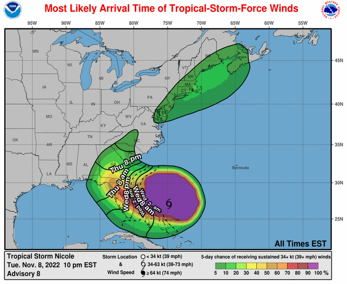
Forecasters at the National Hurricane Center said landfall is expected overnight Wednesday, but Nicole is so large and lopsided that most of the coast will start to feel tropical storm winds and dousing rains and see coastal flooding earlier in the day.
The strongest winds and flood risk appear to be north of the storm’s center, which was projected to stay well north of South Florida, but nearly the entire east coast could see at least a couple feet of storm surge and several inches of rain.
Miami-Dade remained under a tropical storm watch Tuesday evening, with steadily upgraded risk for counties along the coast, including a hurricane watch for Broward and a hurricane warning from Palm Beach north to Volusia County. Storm surge watches and warnings blanketed most of the east coast and some portions of Florida’s west coast, as Nicole is expected to zig-zag through the state before turning north.
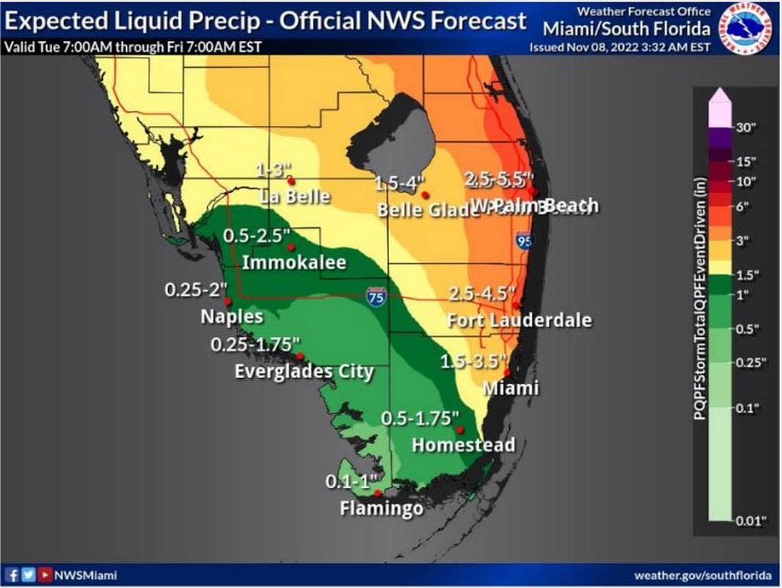
Flooding and rain for South Florida
As of 10 p.m. Tuesday, the National Hurricane Center placed Tropical Storm Nicole 150 miles east-northeast of the Great Abaco Island and about 325 miles east of West Palm Beach. The storm, with sustained winds of 70 mph, was traveling west-southwest at 10 mph.
Earlier Tuesday, the center said Nicole transitioned from a subtropical storm — largely an academic distinction, but a sign that the storm has a bigger wind field and formed over cooler waters — to a tropical storm.
Nicole is very near hurricane strength, forecasters said, and could be a Category 1 hurricane with 75 mph sustained winds by Wednesday as it comes ashore in Florida. But it is unlikely to further strengthen after.
READ MORE: When will Miami and the rest of Florida feel Subtropical Storm Nicole’s rain and wind?
According to forecasters, South Florida could face flooding, heavy rain, a storm surge and high winds Wednesday night and Thursday as the storm slops across the coast. Hurricane conditions are expected in portions of the Bahamas on Wednesday.
Storm surge is expected to peak on Wednesday, when tides are still running high from Tuesday’s king tide, one of the highest annual tides. In Miami-Dade, the hurricane center predicts up to two feet of storm surge. That prediction includes the king tide flooding.
Storm surge predictions get higher farther up the coast, with two to four feet expected in coastal Broward and Palm Beach counties, and three to five feet of surge expected from north of Palm Beach County to Jacksonville.
“The large wind field of Nicole is going to be moving a lot of water around in the next few days,” said Michael Brennan, acting deputy director of the National Hurricane Center, in a Tuesday morning broadcast.
Hurricane WARNING Palm Beach north, Hurricane WATCH/Tropical Storm WARNING Broward, Tropical Storm Watch Miami-Dade.
10AM Tue Nicole NHC data showing no significant forecast track changes in this advisory. Hurricane warning issued due to time of impacts within 36 hour window. pic.twitter.com/fHnk88TXMN— Craig Setzer (@CraigSetzer) November 8, 2022
That, coupled with several inches of rain across the state, could cause some serious coastal flooding.
The National Weather Service’s Miami office predicted up to 7 inches of rain are possible in some spots, but levels will likely be stronger toward the north: around four to six inches in Palm Beach and Broward, with two to four inches expected in Miami-Dade.
However, Nicole is no Ian. The storm is expected to move through the state at a brisk clip — nearly 15 mph — limiting the time it can spend dumping water across the state.
Here’s what is closed and canceled in South Florida because of Tropical Storm Nicole
Standing in front of city workers filling sandbags for distribution Tuesday afternoon, Miami Mayor Francis Suarez advised residents to be careful if water pools under Interstate 395 downtown, where the Florida Department of Transportation is rebuilding the highway.
Suarez said the city has deployed seven portable stormwater pumps to help drain flood-prone neighborhoods, supplementing 12 permanent pumps throughout the city. The mayor said the city has used social media posts to determine where to place portable pumps.
“We have learned from previous storms,” said Commissioner Manolo Reyes.
Bahamas preparations
Before striking Florida, Nicole will rake much of the Bahamas. Emergency managers there on Tuesday appealed to residents in the north and central Bahamas, asking individuals living in vulnerable areas to make final preparation and seek safety as best as they can.
“The storm is now on a path on a course, headed west with winds now up to 60 miles per hour; so it’s definitely on a projected path to impact the northwest Bahamas,” Capt. Stephen Russell, the head of the National Emergency Management Agency, said at 4:45 p.m. as he and others warned of already deteriorating conditions on some family islands.
The path is generally the same as Hurricane Dorian, which slammed into the Abaco Islands and Grand Bahama as a catastrophic Category 5 hurricane three years ago. Tropical Storm Nicole isn’t expected to have the same intensity when it is expected to strengthen early Wednesday morning as it crosses north Abaco, but authorities are concerned nevertheless.
“Please find where the nearest shelters are,” Russell said.
Lake O and district canals prepared
The South Florida Water Management District has been lowering canals throughout South Florida to prepare for Nicole’s rain and surge since Sunday, and district spokesperson Jason Schultz said that the high king tides haven’t slowed down the district’s ability to prepare.
“We have not encountered any issues with king tides hindering our ability to lower canals,” he said.
The storm’s projected path across the state also takes it north of Lake Okeechobee, which rose more than 2.5 feet with Hurricane Ian’s rains. High water levels from additional rain can potentially lead the U.S. Army Corps of Engineers to release some of that water to the east and west, which can aggravate red tide and blue-green algal blooms.
“The potential exists that high-volume releases will be needed following the storm,” the agency said in a press release Tuesday.
Army Corps Spokesperson Erica Skolte said the agency is paying close attention to the forecast and currently doesn’t expect Nicole’s rains to overtop the dike surrounding the lake and protecting nearby residents.
“Based on the most recent forecasts, our analysis indicates no risk of overwash for the common inundation zones around the Herbert Hoover Dike,” she said.
The latest hurricane center forecast shows Nicole heading northwest into Florida before turning north toward Gainesville Thursday afternoon. From there, Nicole’s track takes it toward Valdosta, Georgia and up through the Carolinas, where it is expected to dissipate.
This report will be updated.
Miami Herald editor Jeff Kleinman and Miami Herald staff writers Charles Rabin, Nicolas Rivero, Jacqueline Charles, Joey Flechas and Devoun Cetoute contributed to this coverage.
