Hurricane Earl expected to change status as tropics map calms down
And then there was one.
The National Hurricane Center’s tropics map Saturday evening is a bit calmer than it has been in the past week.
Earl has entered its post-tropical cyclone phase and a disturbance is forecast to move off the coast of Africa next week.
5 am AST Saturday, September 10 Key Messages for Hurricane #Earl.https://t.co/Jc4FU2qN8K pic.twitter.com/WwgMn0fjw9
— National Hurricane Center (@NHC_Atlantic) September 10, 2022
Where’s Earl?
Earl has now become a hurricane-force extratropical low, according to the Hurricane Center’s 5 p.m. advisory.
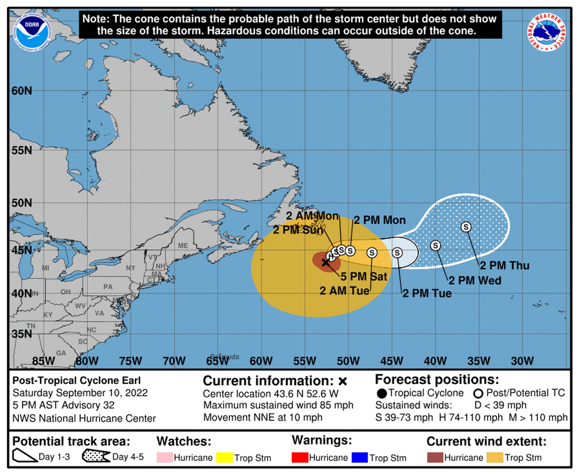
It was about 215 miles south of Cape Race Newfoundland on Saturday.
The large Category 1 storm was moving north-northeast at 10 mph, seeing a significant reduction in forward speed. Earl is expected to move slowly northeastward to the southeast of Newfoundland Saturday night through Monday.
Earl’s maximum sustained winds dropped to 85 mph after holding this morning near 90 mph with higher gusts. Hurricane-force winds from the large cyclone extend outward up to 90 miles from the center and tropical-storm-force winds spread up to 485 miles, the center said.
These winds were expected to affect the Avalon Peninsula of Newfoundland on Saturday afternoon and continue through Sunday.
Earl is forecast to see continued weakening over the weekend and was expected to fall below hurricane status either Saturday night or early Sunday.
Earl’s swells
READ MORE: Will hurricane swells hit Florida’s coast this weekend? What to know about Earl’s impact
Large swells generated by Earl will affect Bermuda, portions of the U.S. East Coast, which includes parts of Florida, and Nova Scotia and Newfoundland during the next several days, according to the Hurricane Center.
“These swells are likely to cause life-threatening surf and rip current conditions.”
Disturbance near African coast
The sole disturbance currently being tracked is on the African coast, according to the Hurricane Center’s 8 p.m. advisory.
It could see some gradual development once it moves into the Atlantic on Monday and starts heading west-northwest. It has a 30% chance of formation through the next five days.
South Florida forecast
Meantime, South Florida continued to swelter on Saturday, with temperatures already above 90 degrees before noon and the heat index in the triple digits by 11 a.m., according to the National Weather Service in Miami.
Scattered thunderstorms are in the forecast for the weekend, ramping up on Monday through Wednesday at a 60% to 80% chance.
Good morning!
It may only be 10AM but it is already a hot and muggy one here in South Florida. Temperature are around 90° and heat indices are already over 100° over much of the area. Be sure to take precautions against heat illness if doing outdoor activities!#Flwx pic.twitter.com/Kn2ZLCDhCA— NWS Miami (@NWSMiami) September 10, 2022
