After the extreme cold, more snow is on the way


 |
The relatively quiet, albeit very cold, weather pattern setting into much of the Midwest and Northeast during the second week of January will be short-lived, AccuWeather forecasters caution, as they monitor for more weather trouble and any storms lurking in the long-range forecast.
A storm originating from western Canada will track southeastward to bring a broad zone of accumulating snow that will result in slippery travel conditions from parts of the Plains and Midwest late this week to portions of the South and interior Northeast this weekend, AccuWeather meteorologists say.
"The storm will operate within and move along a temperature contrast zone," AccuWeather Chief On-Air Meteorologist Bernie Rayno said. Even though the frigid air gripping the Midwest and Northeast will ease up by midweek, another shot of cold air will follow later this week and this weekend. By Friday, high temperatures will be in the single digits F across northern New England. Meanwhile, on the other side of the jet stream, temperatures will climb well into the 40s across parts of the central Plains.
"By the time this storm arrives at the end of the week, there will still be cold air to its north and east and mild air to its south and west, and that should keep the storm going and might even allow it to strengthen," Rayno said.
The storm will be an Alberta clipper that moves southeastward late this week as a new wave of cold air advances.
Clipper storms that originate over western Canada tend to bring only light to moderate snow along a narrow zone as they move swiftly along. But, if circumstances allow, snow can fall over a broad zone, and heavy snow could fall if the storm manages to strengthen and/or come in contact with moisture.
"Given the expected track of the storm, a swath of several inches of snow is likely from parts of Minnesota to Iowa from Friday to early Saturday," Rayno said.
 |
Not only does it appear that Minneapolis and Des Moines, Iowa, are in the path of accumulating snow, but major cites farther to the east, such as Chicago, Indianapolis and Louisville, Kentucky, in the Midwest may have flakes flying for a time this weekend.
There are some different scenarios forecasters are considering about how the storm might behave once it approaches the Appalachians later this weekend with the biggest question being: How soon might the system make a more eastward and northward turn? Cold, dry air may come in so forcefully that it would limit the storm's ability to cause snow to spread over the Northeast states.
CLICK HERE FOR THE FREE ACCUWEATHER APP
Dry air in place is likely to be a factor against heavy snow from falling too far to the north in the Northeastern states -- at least initially. "It is possible that snow from the storm around much of the Great Lakes on Saturday and parts of the central Appalachians on Sunday may only be in the neighborhood of a dusting to an inch or so," AccuWeather Senior Meteorologist Heather Zehr said.
A small accumulation of snow over a broad area that overlaps major airport hubs in the Midwest and Northeast and long stretches of major highways can trigger substantial airline delays and dangerous travel conditions for motorists.
It does appear that the storm will allow snow to dip into parts of the southern Appalachians later Saturday to Sunday. Some sort of wintry mix or a rain-to-snow situation may unfold in eastern, more lower-elevation areas of Georgia, South Carolina, North Carolina and Virginia as well on Sunday. A wintry mix could occur in Raleigh, North Carolina, and Richmond, Virginia, by Sunday with a chance of some snow spreading to Washington, D.C., Philadelphia and even New York City Sunday night.
 |
With the storm being several days away, adjustments to the forecast are likely, once a definitive track and overlay of moisture can be ascertained.
After that, there is the potential for the clipper system to strengthen quickly upon reaching the mid-Atlantic coast early next week.
This coastal evolution would be a way for heavy snow and major travel disruptions to develop along the Interstate 95 corridor. However, the heavy snow risk would be contingent on the track of the storm.
"A lot can happen a week away, and changes to plans and travel are not warranted at this point," Anderson said, explaining that there is just as much chance for the storm on Monday to swing well out to sea before making a northward turn.
One such storm will do just that several days earlier. A storm that forms well off the mid-Atlantic coast is projected to swing northward and produce heavy snow and strong winds over part of Atlantic Canada from later Friday to Saturday. AccuWeather meteorologists will monitor this storm for any westward jog that might bring snow to Boston and coastal areas of New Hampshire and Maine.
"For now, it appears the greatest impacts in eastern New England from the Atlantic Canada storm late this week and early this weekend will be increasing winds and rough seas," AccuWeather Senior Meteorologist Courtney Travis said.
AccuWeather's long-range meteorologists have a storm on their radar for later next week, and they say it may bring wintry trouble to the East.
"The weather pattern during the period from Jan. 20-22 supports heavy snow and disruptions to school and commerce from the central Appalachians to the interior Northeast if a storm takes the track we believe occurs," AccuWeather Lead Long-Range Meteorologist Paul Pastelok said.
 |
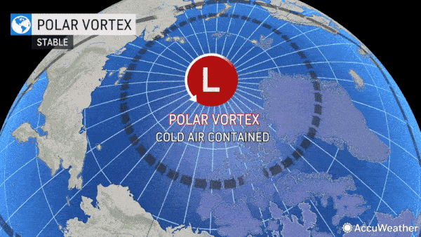
A southward displacement of the polar vortex for January was predicted many weeks in advance and will continue to bring waves of cold air to the Midwest and the Northeast over the next week or two.
Pastelok pointed to a continuance of the southward displacement of the polar vortex, as well as weather factors occurring in the Pacific Ocean and jet stream patterns along the Atlantic seaboard later next week that suggest such a storm may come about.
Regardless of the potential for changing details in the days ahead, the overall weather pattern will continue to operate in a fairly typical January mode for the Midwest and Eastern states and that means that multiple storms are likely to evolve through the end of the month with opportunities for accumulating snow and accompanying travel disruptions, despite a lull during the early part of this week.
For the latest weather news check back on AccuWeather.com. Watch the AccuWeather Network on DIRECTV, Frontier, Spectrum, fuboTV, Philo, and Verizon Fios. AccuWeather Now is now available on your preferred streaming platform.
