How did Tropical Storm Colin sneak up on national weather forecasters in the Carolinas?
For days, forecasters predicted a dreary Fourth of July weekend for much of South Carolina, saying off and on rain showers could interrupt fireworks shows and celebrations.
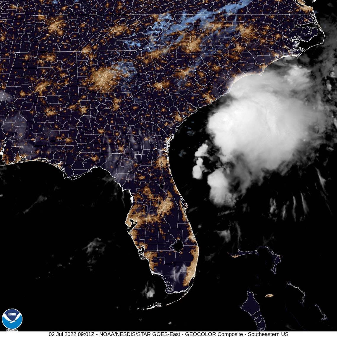
They had no idea a tropical storm would form overnight Friday into Saturday morning, just a few dozen miles off the coast of Myrtle Beach.
“It’s rare for this to happen,” said Tim Armstrong, a meteorologist in the National Weather Service’s Wilmington office.
The only indication that any tropical weather might appear was the National Hurricane Center’s notice Friday afternoon that a low pressure system had developed near Savannah, Georgia, and would likely bring some heavy rain in isolated areas over the weekend.
And yet, Tropical Storm Colin snuck onto the scene early Saturday morning, surprising the National Weather Service. How did this happen though? How was it possible for a tropical storm to spin up overnight with little warning?
Armstrong said Tropical Storm Colin was so weak that it stayed under the radar, literally, until the last minute.
“I can only assume the computer forecast models were unable to see the thunderstorm organization in time,” Armstrong said. “We often have a lead time of a day or two in advance.”
Colin’s impacts have been relatively minimal. Just six hours after the weather service put out a tropical storm warning for Horry and Georgetown counties in South Carolina and Brunswick County in North Carolina, the storm was already dissipating, moving offshore and out to sea.
Colin formed less than a week after the National Oceanic and Atmospheric Administration unveiled new supercomputers that will produce more accurate weather forecasts further in advance.
“More computing power will enable NOAA to provide the public with more detailed weather forecasts further in advance,” NOAA Administrator Rick Spinrad said in a statement June 28 announcing the new technology. “Today’s supercomputer implementation is the culmination of years of hard work by incredible teams across NOAA.”
Forecasters knew there were thunderstorms hanging out over the ocean off the coast of Georgia and South Carolina, but it wasn’t until they neared Myrtle Beach that the National Hurricane Center deemed the system to qualify as a named storm.
But, Colin is barely a named storm, Armstrong said.
“This is just a minimal tropical storm,” he said. “It could not be any weaker and still have a name on it.”
That tends to be the case with these last-minute storms, Armstrong said. It takes time for bigger storms like Hurricane Isaias in 2020 or Hurricane Florence in 2018 to gain enough strength to be dangerous. The extra time, usually days or even a week, required to form a powerful hurricane means forecasters typically have plenty of time to warn the public.
“Every few years we’ll see a system (form quickly) in early- to mid-summer,” Armstrong said. “But fortunately they move out to sea without a lot of impacts on land.
Last year, Armstrong said Tropical Storm Barry did this, appearing quickly off the coast of Charleston with winds of 40 mph and dissipating quickly after landfall to little fanfare.
“The ones that have larger impacts on the area, you have much more warning,” he said.
So far, all Tropical Storm Colin has done is drop 1 to 2 inches of rain Saturday morning across the coastline and blow wind gusts of about 40 mph.
“Any significant weather has pushed offshore and into North Carolina,” Armstrong said.
Brunswick County was still under a tropical storm warning Saturday afternoon, more than three hours after the warnings were canceled for Horry and Georgetown Counties.
If anything, Armstrong said Tropical Storm Colin will be “net positive” for the eastern Carolinas. The region, especially North Carolina, has been under a moderate to severe drought for weeks.
Even as Colin disappears, people still need to be aware one lingering effect it will have for the next day or so — rip currents. And, just because this storm was fairly weak, doesn’t mean the next one will be, too.
“The strong winds offshore are producing big waves” that contribute to rip currents, Armstrong said.
