What is a derecho and why is it so destructive?
A derecho is a significant, potentially destructive weather event that is characterized as having widespread, long-lived, straight-line winds associated with a fast-moving group of severe thunderstorms.
Here’s what you need to know about derechos:
They can produce hurricane-force winds
While there’s no official or universal definition for a derecho, it is classified by a swath of wind damage extending more than 400 miles with wind gusts of 58 mph or greater along most of its length, according to the Storm Prediction Center.
The SPC increased the required path of damage by more than 50% from 240 miles to 400 miles in January 2022 based on a 2016 study. The hope was that the added rigor would help reserve the term “derecho” for the most impactful, long-lasting and widespread events, SPC meteorologists told CNN.
“We’re really trying to highlight with just one word, the worst, most damaging wind event that you can potentially expect,” Matt Elliott, SPC warning coordination meteorologist, told CNN. “If we can keep it to these higher end events, then it can be really meaningful because when you hear that term it’s means that we’re talking about something extremely serious.”
These wind events arise when storms form a continuous and narrow band of thunderstorms ahead of a cold front, also called a squall line, CNN reported.
Their destruction can be similar to that of tornadoes, but it is typically in one direction, along a fairly straight path, the weather service says – hence it’s name, which is Spanish for “straight ahead.” Derecho damage is frequently referred to as straight-line wind damage.
These storms are also known to have several well-separated 75-mile per hour wind gusts and may also cause tornadoes and heavy rains that can bring flash flooding. (Winds of 74 to 95 mph are equivalent to a Category 1 hurricane.)
They’re more common in warmer weather
Derechos are typically associated with lines of thunderstorms that will bow out into a curved shape as winds begin to spread out horizontally.
Known as a bow echo, these storm bands can develop from a cluster of thunderstorms or just a single storm, according to the weather service. The storm band advances when new thunderstorms form as warm air is forced upwards by the cooler air spreading out. If this band of storms travels more than 240 miles and has gusts of over 58 mph, it becomes a derecho.
These intense wind events thrive on the border of a “strong area of high pressure aloft where the greatest overlap of hot and dry conditions and stronger wind aloft occurs,” according to the weather service.
Derechos are sometimes preceded by “ominous-looking ‘shelf’ clouds,” according to the Storm Prediction Center. Their clouds can also appear darker than other storms.
The storms are more common in warmer weather conditions, according to the weather service, with 70% of them occurring between May and August.
From September through April, derechos are most likely to occur from east Texas into the southeastern states, they said.
They’re one of the costliest severe storms
Winds within a derecho can be as strong as a tornado, knocking out trees, powerlines, mobile homes, barns and other similar structures, according to the Storm Prediction Center.
They are most dangerous to those outdoors, whether in a rural or urban area. However, cities are particularly vulnerable to these high winds due to damage to electrical and communication lines, falling trees, and damage to buildings.
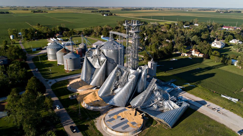
In August 2020, a severe thunderstorm event impacted the Midwest as a derecho and produced severe wind damage across Nebraska, Iowa, Illinois, Wisconsin, Illinois and Indiana.
The derecho’s $11 billion in damage places it among the top three costliest severe storm events ever, alongside two major tornado outbreaks in 2011 (tropical cyclones are ranked separately from severe storms).
The 2020 derecho caused widespread power outages, devastated trees and damaged crops. More than 20 million people over an area of 90,000 square miles were affected. In Iowa and Illinois alone over 1 million people were left without power.
UPDATE: The Storm Prediction Center changed its definition of a derecho in January 2022, increasing the required path of damage to more than 400 miles. It made the change to reflect the latest science on the topic, to better align with other weather authorities that had adopted the change and to increase the consistency of communication across all of its websites, an agency spokesperson said. This story has been updated to reflect the newest definition.
CNN’s Haley Brink, Hannah Gard and Monica Garrett contributed to this report.
For more CNN news and newsletters create an account at CNN.com
