Tropical Storm Danielle could soon become the first Atlantic hurricane of 2022
Tropical Storm Danielle is getting stronger and is expected to become the first hurricane of the season sometime Friday, forecasters said.
Danielle formed Thursday morning in the northern Atlantic and is the fourth named storm of the 2022 Atlantic hurricane season, which has been unusually quiet despite NOAA predicting an above-average season.
This has been the least active start to a hurricane season in more than 30 years, with the end of August marking a record of two months without a named storm forming in the Atlantic before Danielle. Forecasters are also monitoring two disturbances in the Atlantic, one of which has a chance of turning into a tropical depression over the next few days.
So, where is Danielle now and where is it going? And what about the two other systems?
Here’s what to know:
Tropical Storm Danielle forecast
Danielle is about 890 miles west of the Azores and is neither a threat to Florida nor to the rest of the United States, according to the National Hurricane Center’s advisory at 5 a.m. Friday.
Forecasters say the water is warmer then usual, which combined with light to moderate shear, should led to the strengthening of the system and a forecast of it becoming a hurricane by Friday.
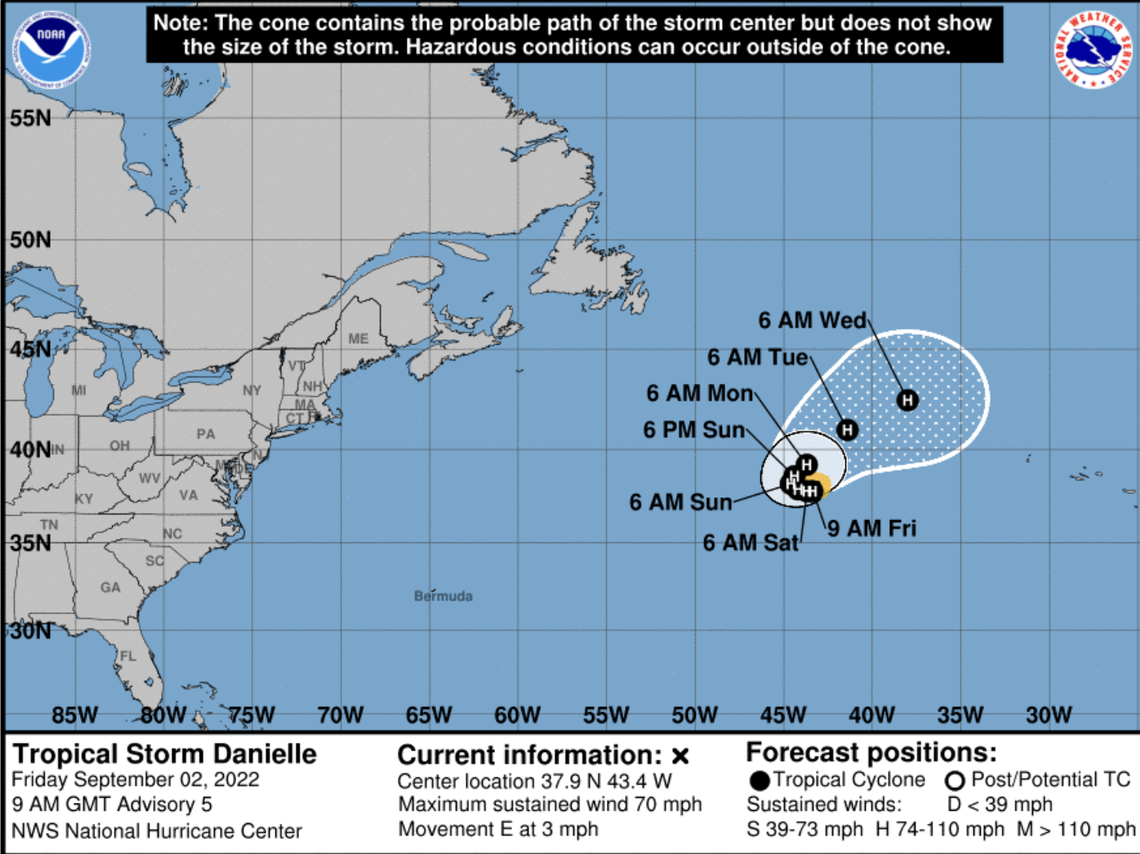
The forecast shows Danielle, which has maximum sustained winds near 70 mph with higher gusts, slowly drifting east. Forecasters say Danielle could potentially strengthen into a Category 2 hurricane in the next few days.
By early next week, the storm should be over cooler waters with higher shear, which could weaken it.
The Atlantic has had no #hurricanes yet this year. This is the 7th time since 1950 that the Atlantic has gone through August without a #hurricane. Other years are: 1967, 1984, 1988, 2001, 2002, 2013. pic.twitter.com/VqS44nP1o3
— Philip Klotzbach (@philklotzbach) August 31, 2022
READ MORE: Will it rain in Miami on Labor Day weekend? How hot will it get? What the forecast says
Two other disturbances
Forecasters are monitoring a disturbance several hundred miles east of the Leeward Islands that could turn into a tropical depression in the next several days. The system is forecast to move slowly west-northwest, toward the adjacent waters of the northern Leeward Islands.
“Although environmental conditions remain only marginally conducive, any additional development of the system over the next few days would lead to the formation of a tropical depression,” the hurricane center said in its 8 a.m. advisory Friday.
Forecasters expect it will bring heavy rain to portions of the Leeward Islands during the next couple days, regardless if it develops or not. A hurricane hunter aircraft is scheduled to investigate the disturbance Friday afternoon, if necessary.
The hurricane center Thursday afternoon lowered its formation chances from 60% to 50% through the next 48 hours and from 80% to 70% through the next five days. Its formation chances remained the same as of Friday morning.
Forecasters also have on their radar a disturbance to the northwest of the Cabo Verde Islands. The hurricane center no longer thinks the system will turn into a tropical depression, noting that it’s “moving into an area of less favorable environmental conditions, and significant development is not anticipated.”
It has a low 10% chance of formation through the next five days.
Miami Herald staff writer Devoun Cetoute and Omar Rodríguez Ortiz contributed to this report.
