Dangerous snow squalls to accompany cold blast from Midwest to Northeast
In the wake of the powerhouse storm that affected the Northeast with heavy rain and strong winds on Monday, sharply colder air will sweep in through Tuesday. However, included in the quick change to wintry conditions with areas of lake-effect snow and flurries will be brief bursts of heavy snow that can be dangerous for those traveling on the highways, AccuWeather meteorologists warn.
The cold air won't quite meet up in time with the powerful storm moving through the Northeast to create a bona fide snowstorm, but while delayed, it will not be denied, nor will some impactful snow.
"A burst of very cold air will surge across the Great Lakes, Ohio Valley and Northeast in the immediate wake of this storm and will lead to one of winter's greatest dangers for highway motorists across the region," AccuWeather Meteorologist Jake Sojda said.
 |
Sojda is referring to snow squalls, which are the wintertime equivalent to summertime gusty showers and thunderstorms.
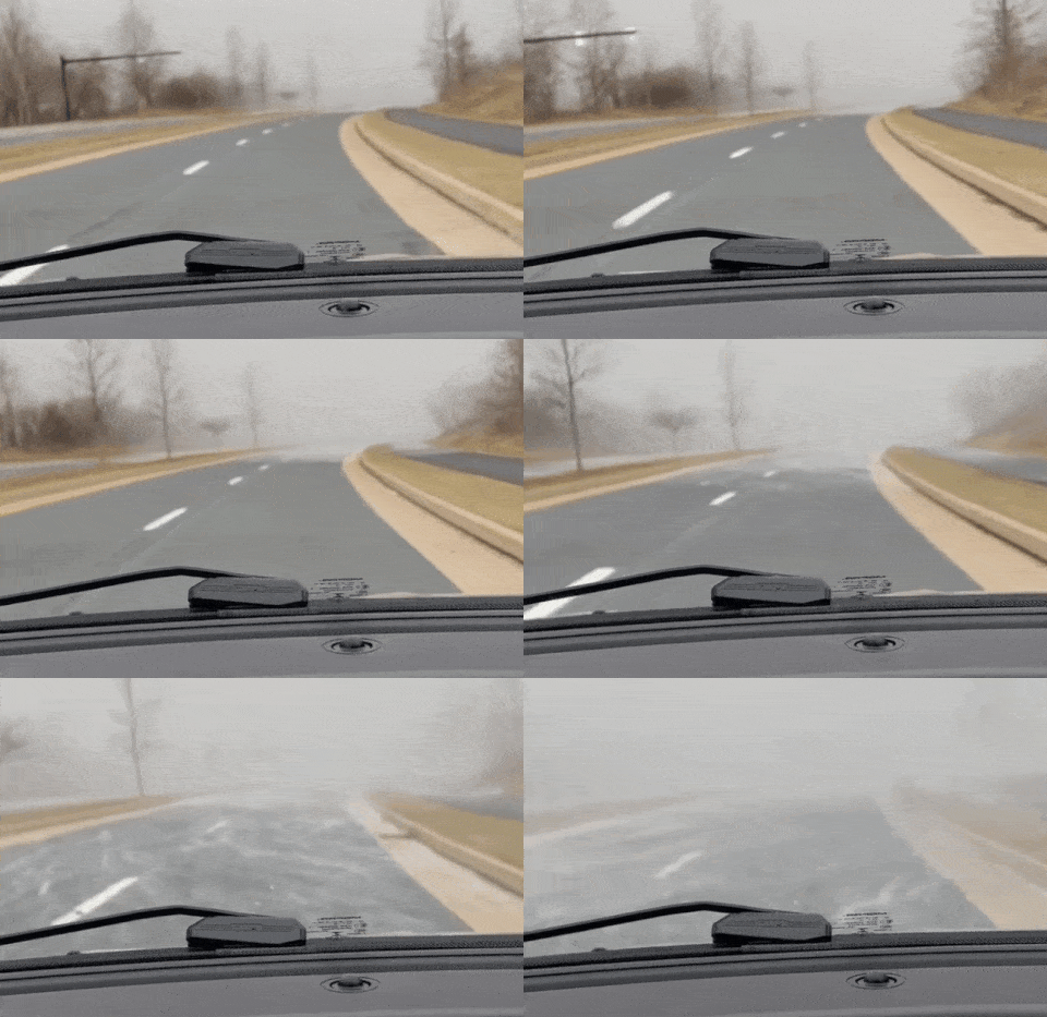
Just as the summer storms bring quick bursts of rain and ponding on the highways, snow squalls can bring a drop to near-zero visibility in a matter of a few seconds and cause roads to transition from dry to wet to snow-covered and icy in a minute or so. When snow squalls occur along interstate highways, where vehicles are traveling at 55-70 mph, it is no wonder that massive pile-ups occur.
 |
This video clip was captured while encountering a snow squall in State College, Pennsylvania, on Feb. 19, 2022. The speed of the video was accelerated to simulate what motorists may encounter while traveling at full highway speeds. (Credit Alex Sosnowski) |
As the cold air builds and moisture from the powerful storm lingers, widespread snow showers and even some heavy squalls will continue through Tuesday morning in the Northeast.
Have the app? Unlock AccuWeather Alerts™ with Premium+
"For most areas, this will not result in significant snow totals, but multiple heavy bursts of snow all the way from Michigan and northern Indiana through Ohio and much of the Appalachians into New England can bring quick accumulations of an inch or two of snow and treacherous driving conditions," Sojda said.
Dangerous travel conditions occurred across Michigan on Monday, including just west of Kalamazoo, where multiple vehicles were involved in a pileup on Interstate 94. This led to the eastbound lanes of the highway being shut down for a time.
 |
Where the snow is persistent, mainly in the typical lake-effect snow belts southeast of Lake Erie and Lake Ontario, and in the mountains of the central Appalachians, several inches of snow is likely to pile up by Tuesday morning.
"A few of the hardest-hit areas south of Buffalo, New York, and in the mountains of West Virginia could pick up snow totals in the double digits," Sojda said.
 |
It is likely that rain or snow showers will reach the I-95 zone from Washington, D.C., to Philadelphia and New York City into early Tuesday morning.
The sweep of cold air coming into the Midwest and Northeast will have some shock. Even though temperatures associated with the cold blast will be fairly typical of the middle of December, the chill will follow unusually mild conditions and an unusually warm coastal stretch for mid-December.
High temperatures on Monday morning challenged records in the Northeast as the storm drew warm air northward by more than 1,500 miles from the Gulf of Mexico and the Caribbean. The temperature in Boston reached 63 degrees Fahrenheit on Monday, breaking the previous record by two degrees. Temperatures in Caribou, Maine and Islip, New York also broke daily high records on Monday. However, colder air swept in from the Midwest during the afternoon and evening as winds flipped from southerly to westerly.
 |
In New York City, temperatures surged to 62 degrees as the center of the storm passed nearby on Monday morning, but plunged into the low 50s into the afternoon and into the 30s Monday night. Only a little rise in temperature is likely on Tuesday with temperatures much of the day in the low 40s and snow showers in the vicinity.
It's a similar story in Pittsburgh. Following high temperatures in the 50s on Sunday, temperatures fell into the 30s on Monday afternoon and into the mid-20s on Monday night with flurries and heavier snow squalls.
The upcoming cold snap will be brief, as temperatures will moderate during the middle and latter part of the week.
Want next-level safety, ad-free? Unlock advanced, hyperlocal severe weather alerts when you subscribe to Premium+ on the AccuWeather app. AccuWeather Alerts™ are prompted by our expert meteorologists who monitor and analyze dangerous weather risks 24/7 to keep you and your family safer.


