‘Dangerous day’: Wichita in area with greatest threat of tornadoes, severe storms
Updated Monday: The National Weather Service in Wichita has expanded the area that could be threatened by dangerous storms carrying up to softball-sized hail, 80 mph winds and destructive “long-track” tornadoes across a larger portion of southern Kansas.
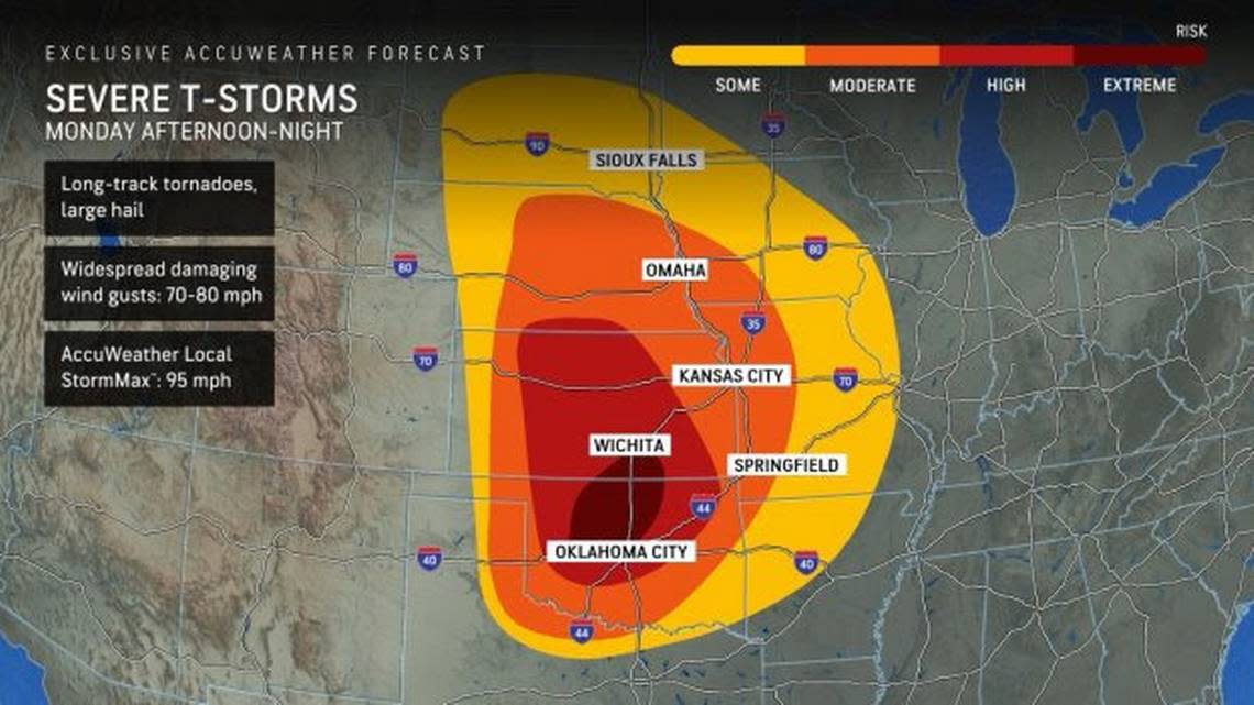
The storm threat prompted AccuWeather meteorologists to issue a rare “extreme risk” of tornadoes and thunderstorms for the central part of the U.S.
Part of southern Sedgwick County, including Wichita, sits in the area with the greatest risk.
“It’s a dangerous day,” AccuWeather Chief Meteorologist Jon Porter said. “Not every area under an ‘extreme risk’ will see storms today, but the storms that do develop will have the potential for strong tornadoes. Today is the most widespread, significant risk for strong tornadoes in the Southern Plains in the last 5 years.”
Thunderstorms are most likely to begin in Wichita and the surrounding areas between 4 p.m. and 11 p.m., according to the National Weather Service. Portions of the state west of Salina, Hutchinson and Harper could see storms as early as 2 p.m., and they’re expected in a swath east of Topeka, Emporia and Coffeyville between 8 p.m. and 2 a.m. Tuesday.
On Monday afternoon, the National Weather Service issued a tornado watch in effect until 11 p.m. for 16 counties. Those include Butler, Cowley, Harper, Harvey, Kingman, Reno, Sedgwick and Sumner counties in south-central Kansas and Chase, Marion, McPherson, Rice and Saline counties in central Kansas. Chautauqua, Elk and Greenwood counties in southeast Kansas are also in the watch area.
Cities in the watch area include Wichita and the surrounding towns, Arkansas City, Cottonwood Falls, El Dorado, Eureka, Harper, Hutchinson, Kingman, Marion, McPherson, Newton, Peabody, Rose Hill, Salina, Wellington and Winfield.
As part of its Monday 8:49 a.m. update, the weather service announced that all of Harper, Sumner and Cowley counties and parts of Kingman, Sedgwick, Butler, Barber, Elk and Chautauqua counties now have the highest ranking for severe storm risk.
Forecasters are warning of 70-80 mph winds, baseball to softball sized hail and the “greatest potential for a few strong & long track tornadoes” in those areas and also stretching down into Oklahoma.
The southern portions of Sedgwick and Butler counties, including Wichita, are among the areas that could see the worst storms.
“An outbreak of severe thunderstorms continues to favor southern Kansas this afternoon and evening,” the NWS said Monday morning.
AccuWeather is predicting the greatest threat along the Interstate 35 corridor from Wichita to Oklahoma City, including a “growing concern” for dangerous night-time tornadoes.
“This extreme risk for severe storms lasts well into the night as it evolves into a line of thunderstorms with embedded tornadoes. The line of storms will blast east across Kansas and Oklahoma toward Kansas City and Springfield, Missouri tonight,” Porter said.
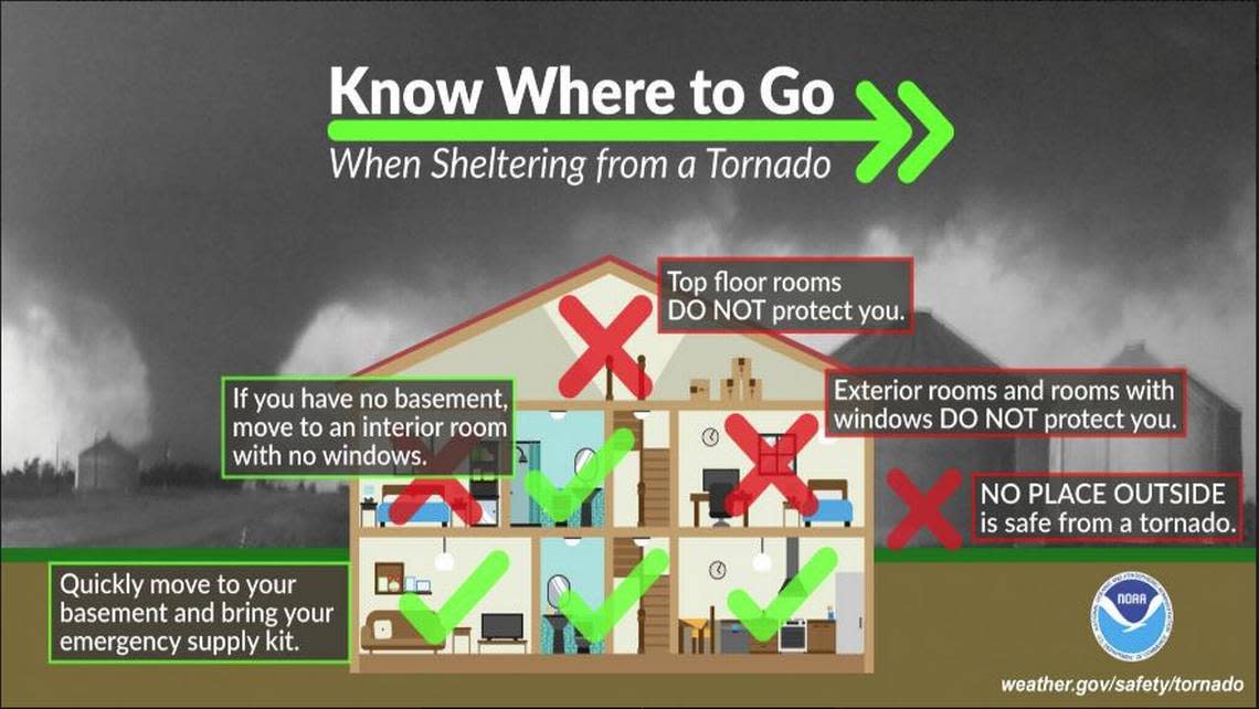
“Nocturnal tornadoes are extremely dangerous. Tornadoes can be nearly impossible to see in the dark, especially if they’re wrapped in rain. Navigating through tornado damage in the dark is also extremely dangerous for storm survivors and first responders. Everyone in this area needs to keep their cell phone charged, notifications turned on, and volume turned up, so they do not sleep through a tornado warning.”
Counties in south-central Kansas surrounding the high-risk area, including Reno and Harvey counties, could also see 70-80 mph winds, golfball to baseball sized hail and the possibility of “a few strong tornadoes,” the NWS said.
Areas of western, northern and eastern Kansas, including Hays, Salina and Topeka, could see winds up to 70 mph and up to two-inch hail. Tornadoes are also possible, the weather service says.
The last time AccuWeather issues an “extreme risk” for storms was more than a year ago, on April 4, 2023, when nearly two dozens tornadoes torn through Illinois, Missouri, Wisconsin, Iowa and Arkansas.
Scattered to numerous thunderstorms will affect the region this afternoon and evening. Some of the storms will be severe, capable of very large hail, damaging winds, and tornadoes. The greatest severe weather threat will be over southern Kansas and Oklahoma. #kswx pic.twitter.com/xFCCx32dji
— NWS Wichita (@NWSWichita) May 6, 2024
Original story: A large swath of Kansas is expected to see dangerous thunderstorms Monday and Wichita is forecast to fall into an area where the most severe weather could occur.
That area — which includes Wichita near the top northeast corner, most of Pratt County in the northwest and south into Oklahoma — has a higher chance than other parts of the state for seeing “a few strong long track tornadoes,” winds up to 80 mph and up to softball-size hail, the National Weather Service in Wichita said just after 5 p.m. Sunday.
Wichita is most likely to see thunderstorms from 4 p.m. to 11 p.m. Monday.
“The greatest potential for higher-end severe weather could shift further south into Oklahoma,” the NWS in Wichita said. “There is also potential for higher-end severe weather to expand further east across the southern Flint Hills of SE KS.”
Much of central and eastern Kansas are the area that could also see tornadoes, up to two-inch diameter hails and winds up to 70 mph.
Here is our latest timing graphic for Monday's severe weather potential. #kswx pic.twitter.com/jESD3ZaLLC
— NWS Wichita (@NWSWichita) May 5, 2024
