Here comes the heat, Savannah; near-record highs forecast for Wednesday, Thursday
Savannah is in for a pre-summer swelter and a potential repeat of Monday’s thunderstorms.
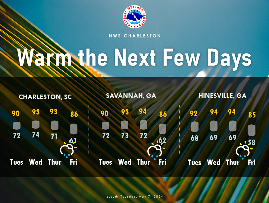
An Atlantic high-pressure system lingering over coastal Georgia and the South Carolina Lowcountry will drive temperatures well into the 90s Wednesday and Thursday, according to the National Weather Service.
Storms are possible beginning Thursday.
"Plausible scenarios range from there being no thunderstorm activity at all to a severe squall line tracking across southeast Georgia and southeast South Carolina in the afternoon and evening hours” Thursday, the weather service’s Charleston office said Tuesday.
More spores: Steamy, historic Savannah drives Georgia's inclusion among America's moldiest states
The outlook for temperatures is not so iffy.
Forecast highs for Savannah are 93 degrees Wednesday and 94 degrees Thursday. The records for May 8 and May 9 are 96 (in 1986) and 95 (in 1962), respectively.
There is a 30% chance of showers or thunderstorms after 2 p.m. Thursday, rising to 50% overnight. Wind gusts of 24 mph and up to a half-inch of rain are possible.
Temperatures should moderate Friday, but that change will come with a higher probability of rain.
Friday’s forecast calls for highs in the mid-80s and 70% rain chance.
The weekend forecast is for sunny skies Saturday and Sunday, with temperatures in the low to mid-80s.
Average high temperatures in Savannah for the second week of way are about 84. The city’s warmest weather so far this year was during an April heat wave. The temperature hit 90 for three consecutive days beginning April 18.
John Deem covers climate change and the environment in coastal Georgia. He can be reached at jdeem@gannett.com
This article originally appeared on Savannah Morning News: Savannah faces heat wave, potential storms Wednesday, Thursday
