How cold will Florida get as the temperatures plunge this week? What the forecast says
Cold as Christmas in the middle of January.
That’s the forecast for Miami Sunday morning when the low is expected to be 45 degrees — same as it was on Christmas morning, said Larry Kelly, meteorologist for the National Weather Service.
“So we’ll see how it goes as we get a little closer to the weekend to make any tweaks to those temperatures, but a cool-down, for sure,” Kelly said.
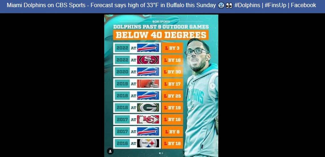
At least we’ll be warmer than Dolfans who are in the stands at Highmark Stadium in Orchard Park, New York, Sunday afternoon as the Miami Dolphins face the host Buffalo Bills in the NFL playoffs.
The high Sunday at the Dolphins-Bills football game? Just 34 degrees. Miami will rise from its 45 degree start and may get up to 70, Kelly said.
The difference between this cold front and the Christmas shivers? This one won’t sit over South Florida for days.
By Martin Luther King Day on Monday, the warming trend will be in play. Expect highs in the mid-70s and lows in the upper 60s on the holiday, Kelly said.
Miami got a taste of what’s to come Wednesday morning when temperatures in Miami dipped to 52 with some interior parts of the county in the upper 40s, said CBS Miami meteorologist Lissette Gonzalez.
NEXT Weather meteorologist @LissetteCBS4 says after a cool morning we'll have a pleasant afternoon with highs in the mid to upper 70s. More: https://t.co/x8EQwC92DC pic.twitter.com/uWsLdAklpH
— CBS4 Miami (@CBSMiami) January 11, 2023
Gonzalez has teased about this since her Monday broadcast when she told viewers, “Wait until you see how cooler it will be by next weekend.”
The strong cold front is expected to approach from the west on Friday and behind that front will be the only hint of rain we’ll see for days into the next midweek — just 20% Friday in Miami, the weather service noted.
The coldest night in the forecast is Saturday into Sunday morning, Kelly said, with lows in the upper 40s. By Sunday morning, temperatures will be in the low 40s across western portions of the East Coast metro and mid-40s in metro downtown areas.
It’s too soon to talk about frost or freeze warnings, but winds will be elevated Saturday morning — gusts around 25 mph — and that makes it more difficult for frost or a freeze to develop. The winds will die down a little by Sunday, Kelly said.
The Lake Okeechobee area could see low wind-chill numbers, and forecasters will know more as the week progresses. But northern interior areas could see mid- to upper 30s.
Highs Saturday will be in the low 60s across the East Coast, and then warmer by Sunday afternoon.
Even the toasty Florida Keys should brace for the cold snap with temperatures rapidly falling from Friday’s peak 78 and 30% rain chance on a windy day. Weekend lows in Key West and the island chain are forecast in the mid-50s.
Change is on the horizon! A cold front will move through the #FLKeys Fri. Behind this front, strong northerly winds will quickly develop along with a much cooler air mass. In fact, temperatures on Fri will peak early in the afternoon and then steadily fall. #KeyWest #FLwx #Keyswx pic.twitter.com/yPmdgriPPG
— NWS Key West (@NWSKeyWest) January 11, 2023
Threats with the front
The weather service warns of an elevated risk of rip currents late week into the long weekend at all South Florida beaches — where only tourists and snowbirds dare dip into the waters. So, if you’re one of them, pay heed. Rip currents can be deadly. Marine conditions could be hazardous late Friday into the weekend, too.
Shelters opening
Broward County declared a two-day cold weather emergency so as to open shelters this weekend to those experiencing homelessness.
The hours are from 6 p.m. Friday to 9 a.m. Saturday and 6 p.m. Saturday to 9 a.m. Sunday.
Those in need of shelter can report to the following venues in Fort Lauderdale no later than 6 p.m. on either or both days, Friday or Saturday, for transportation or access to the shelters.
The Salvation Army at 1445 W Broward Blvd. and HOPE South Florida at 1100 N Andrews Ave.
If the weather forecast changes to predict warmer or colder conditions, cold weather emergency shelter nights may be canceled or extended, according to the county.
Lows around Florida
Here are some forecast lows, and highs, around the state for the long holiday weekend. Clear, sunny skies follow the cold front’s leading rains statewide.
This weekend looks COLD in Florida, with many of us waking up to 30s and 40s on Sunday morning! BURRRR!!! #flwx pic.twitter.com/Q6czsRh3qQ
— Dylan Federico (@DylanFedericoWX) January 9, 2023
▪ Orlando rains on Mickey Mouse with a 60% chance Friday and temperatures drop to a forecast low of 38 degrees Saturday night and a high of 63 Sunday afternoon. Martin Luther King Day’s high reaches just above 70 with a low of 53 that night.
▪ Bradenton, Tampa Bay area has a 60% rain chance Friday and a forecast low of 42 degrees Saturday night and a high of 65 Sunday afternoon. Martin Luther King Day’s high reaches 73 with a low of 55 that night.
▪ Tallahassee and the Panhandle soak first on an 80% rain chance Thursday night then drop to a forecast low of 32 degrees Saturday night and a high of 62 Sunday afternoon. Martin Luther King Day’s high reaches about 67 with a low of 53 that night.
▪ Gainesville greets the chill with a 70% rain chance Thursday night then drops to a forecast low of 31 degrees Saturday night and a high of 62 Sunday afternoon. Martin Luther King Day’s high reaches about 70 with a low of 48 that night.
▪ Sanibel-Captiva has 60% rain chance Friday then drops to a forecast low of 48 degrees Saturday night and a high of 65 Sunday afternoon. Martin Luther King Day’s high reaches 72 with a low of 63 that night.
Will it snow in Florida this holiday weekend? Temperatures forecast below freezing
*FLORIDA TURNING COLDER* once again this weekend, lowest since Christmas. Models agree on 40s for Southwest Florida, with potentially even a few 30s inland too. Details now on @WINKNews. pic.twitter.com/pMLO6W94K3
— Matt Devitt (@MattDevittWINK) January 10, 2023
