How close will Miami get to a high temperature record before a cold front weekend relief?
Weatherwise, you may feel you’re jumping in and out of a sauna Thursday in South Florida ahead of a cold front that will bring Miami closer to where it should be at this time of year.
According to National Weather Service in Miami meteorologist Sammy Hadi, the front approaching Miami on Thursday won’t be nearly as chilly as what the area experienced on Christmas.
Friday’s temperatures should reach the middle to upper 70s. The low on Saturday morning in the early hours will be the coldest, with lows in the 60s along the east coast of South Florida and perhaps the upper 50s in the western suburbs, Hadi said.
“The main thing to take away from this cold front is that this will knock us down into where we should be,” Hadi said. “High temperatures should normally be in the middle- to upper-70s this time of year. But we’ve been above average — actually today.”
Jan 5: A warm day with temps in the low to mid 80s across South Florida ahead of a cold front. A few isolated showers will be possible as the front moves through later today. #flwx pic.twitter.com/FonESSvo6F
— NWS Miami (@NWSMiami) January 5, 2023
Heat records
Miami and Fort Lauderdale could meet or break a record high temperature for Jan. 5, the service initially forecast.
The record high in Miami on a Jan. 5 was 85 degrees in 1908. Miami beat the record, notching 86 degrees, the weather service announced Thursday afternoon.
The record high in Fort Lauderdale on a Jan. 5 was 87 in 1924. No new record.
But West Palm Beach, like Miami, was 85 in 1908 and set a new record at 86 on Thursday afternoon.
The forecast high ahead of the cold front for this Jan. 5 was 84 degrees.
Daily record high temperatures were set today in Miami and West Palm Beach, both reaching 86°F. These break the previous records of 85°F, which both locations measured in 1908. ️
A cooling trend to seasonable temperatures will begin tonight as a cold front moves across S FL. pic.twitter.com/m1QC86pGEm— NWS Miami (@NWSMiami) January 5, 2023
“The main reason for why we’ve been having so much above average temperatures and basically haven’t had a cold front come through since around Christmastime is that we have a southerly flow so the winds out of the south ahead of the approaching cold front is allowing warm air to basically move across the Everglades and across our area,” Hadi said.
Key West is looking at highs in the upper 70s and lows in the upper 60s through the weekend, with minimal rain chance, according to the weather service.
Chance of rain
Don’t expect much rain with this front, he said. “Nothing like they saw yesterday up in Jacksonville and up north in Georgia where they had tornadoes and severe thunderstorms. This is going to mostly be shower activity. Maybe one rumble of thunder, too, when it gets wet by the time it gets to the Broward and Miami counties overnight. It’s not going to be much,” Hadi said.
Saturday will be clear. Sunday has a 30% rain chance in South Florida, according to the weather service.
There will be an elevated risk of rip currents on Friday for all South Florida beaches with the passage of the cold front, according to the service. This risk continues into the weekend.
Weather highs and lows
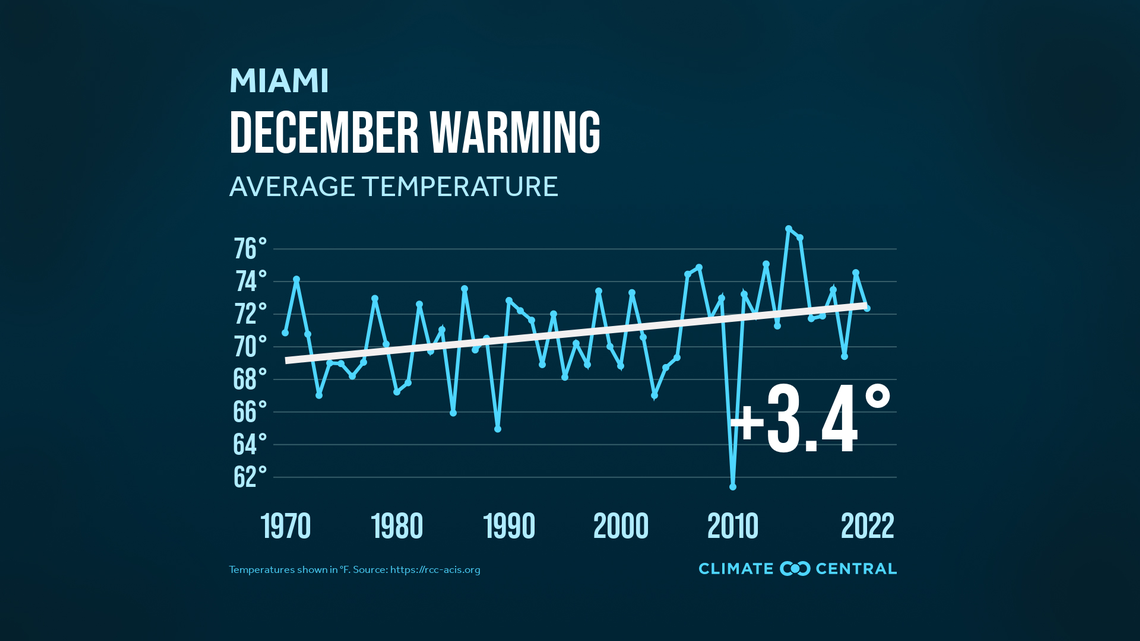
According to the NOAA’s National Centers for Environmental Information, December, despite the Christmas cold, was much warmer and drier than normal.
The average temperature of 72.3 degrees was 1.1 degrees above normal.
The 1.73 inches of rain was 71% of the normal amount.
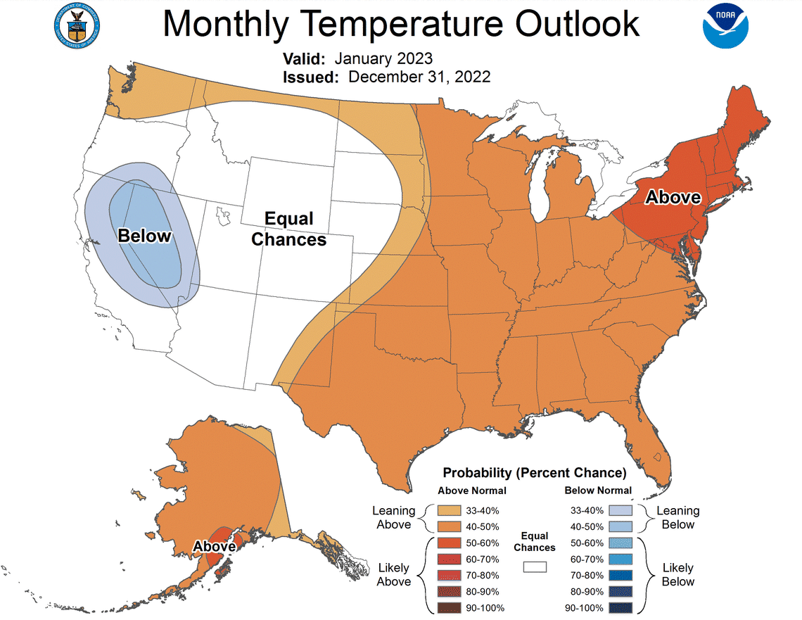
“Decembers in Miami are getting hotter, leading to a change of 3.4 degrees since 1970,” Peter Girard of Climate Central told the Miami Herald in an email. The forecast for January from NOAA’s Climate Prediction Center suggests that Florida is slightly favored to be warmer than normal,” he said.